Category:Maps of the history of Lviv Oblast
Regions of Ukraine:
Oblasts: – Cities: – Autonomous Republic:
Oblasts: – Cities: – Autonomous Republic:
Media in category "Maps of the history of Lviv Oblast"
The following 18 files are in this category, out of 18 total.
-
 1860 Bruckenthal.png 368 × 287; 172 KB
-
 1860 Ebenau Stodółki.png 347 × 286; 197 KB
-
 1860 Haliczanów Burgthal.png 378 × 376; 275 KB
-
 1860 Rosenburg.png 559 × 500; 617 KB
-
 1860 Uliczno.png 857 × 700; 1.33 MB
-
 Bobrka Ernsdorf,Rehfeld,Muelbach.png 880 × 1,400; 2.72 MB
-
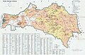 Deutsche Siedlungen in Galizien 1913.jpg 3,000 × 1,920; 3.22 MB
-
 DobrostańWeissenberg1860.png 605 × 589; 670 KB
-
 KaraczynowSchoenthal1860.png 463 × 297; 285 KB
-
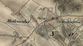 Maleniska1860.png 795 × 443; 707 KB
-
 MoosbergBerdichauKleindorf1860.png 888 × 461; 820 KB
-
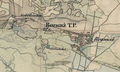
 OżydówAniełówka1860.png 931 × 674; 1.2 MB
-
 PluhówBranisławówka1860.png 1,289 × 968; 2.56 MB
-
 RozważSobolówka1860.png 642 × 386; 478 KB
-
 RzeczyczanyHartfeld1860.png 587 × 511; 592 KB
-
 Walddorf1860.png 313 × 204; 134 KB
-
 ZazdrośćPantelicha1860.png 686 × 738; 801 KB
-
 ZbadynKuttenberg1860.png 605 × 411; 536 KB


