Category:Maps of the history of Main-Tauber-Kreis
Urban districts (cities):
Use the appropriate category for maps showing all or a large part of Main-Tauber-Kreis. See subcategories for smaller areas:
| If the map shows | Category to use |
|---|---|
| Main-Tauber-Kreis on a recently created map | Category:Maps of the Main-Tauber-Kreis or its subcategories |
| Main-Tauber-Kreis on a map created more than 70 years ago | Category:Old maps of Main-Tauber-Kreis or its subcategories |
| the history of Main-Tauber-Kreis on a recently created map | Category:Maps of the history of Main-Tauber-Kreis or its subcategories |
| the history of Main-Tauber-Kreis on a map created more than 70 years ago | Category:Old maps of the history of Main-Tauber-Kreis or its subcategories |
Subcategories
This category has only the following subcategory.
Media in category "Maps of the history of Main-Tauber-Kreis"
The following 9 files are in this category, out of 9 total.
-
 Bahnstreckennetz LK Main-Tauber.png 1,000 × 762; 256 KB
-
 Bahnstreckennetz LK Main-Tauber.svg 1,000 × 762; 261 KB
-
 BW-AlteLandkreise-MGH.png 221 × 278; 37 KB
-
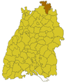 BW-AlteLandkreise-TBB.png 221 × 278; 37 KB
-
-
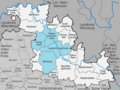
 Verwaltungsgemeinschaft Bad Mergentheim.png 1,000 × 750; 242 KB
-
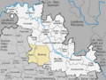 Verwaltungsgemeinschaft Boxberg (Baden).png 1,000 × 750; 239 KB
-
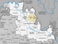 Verwaltungsgemeinschaft Grünsfeld.png 1,000 × 750; 239 KB
-
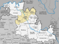 Verwaltungsgemeinschaft Tauberbischofsheim.png 1,000 × 750; 242 KB


.png)

