Category:Maps of the history of Nepal
Subcategories
This category has the following 2 subcategories, out of 2 total.
D
O
Pages in category "Maps of the history of Nepal"
This category contains only the following page.
Media in category "Maps of the history of Nepal"
The following 20 files are in this category, out of 20 total.
-
 Map of Nepal (1814).png 815 × 667; 844 KB
-
 Battle of Makwanpur1763.jpg 640 × 592; 183 KB
-
 Delhi sultanate.JPG 434 × 358; 9 KB
-
 Gorkha Empire 1805.jpg 465 × 269; 58 KB
-
 Greater Nepal (with Nepalese Tibetan war expansions).png 1,058 × 529; 91 KB
-
 Gupta Empire 320 - 600 ad.PNG 503 × 703; 24 KB
-
 Kingdom of nepal.png 7,000 × 5,000; 10.04 MB
-
 Kiranti or Kirati People (B.C. 1500 to 2016 A.D.).jpg 897 × 731; 183 KB
-
 Kirat Dynasty 800 B.C.jpg 1,334 × 750; 90 KB
-
 Kirat Dynasty 800 B.C.png 1,334 × 750; 126 KB
-
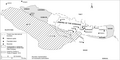
 Lost territories of Nepal after Treaty of Sugauli.jpg 2,908 × 1,532; 1.88 MB
-
 Magadha early expansion.gif 1,500 × 891; 1.85 MB
-
 Naya Muluk.png 547 × 476; 548 KB
-
 Nepal - Tractat de Sugauli.png 1,503 × 629; 85 KB
-
 Sugauli Treaty cessions.png 1,058 × 529; 74 KB
-
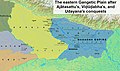
 The eastern Gangetic plain after Ajatasattu's conquest of Kosala.jpg 1,500 × 891; 2.36 MB
-
-
 The eastern Gangetic plain after Bimbisara's conquests.jpg 1,500 × 891; 2.36 MB
-
 The eastern Gangetic plain before Bimbisara's conquests.jpg 1,500 × 891; 2.36 MB
-
 सुगौली सन्धी पूर्व नेपालको भूभागहरु 2014-06-19 18-03.PNG 300 × 150; 21 KB
.png)


.png)


.jpg)


