Category:Maps of the history of the Ottoman Empire in the 1680s
Maps of the history of the Ottoman Empire by decade: ◀ · 1600s · 1610s · 1620s · 1630s · 1640s · 1650s · 1660s · 1670s · 1680s · 1690s · ▶
Media in category "Maps of the history of the Ottoman Empire in the 1680s"
The following 34 files are in this category, out of 34 total.
-
 Ottoman 1683 (orthographic projection).png 2,000 × 2,000; 637 KB
-
 Ottoman 1683.jpg 280 × 200; 48 KB
-
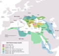
 OttomanEmpire1683.png 3,596 × 2,582; 1.21 MB
-
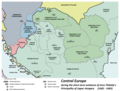 Central europe 1683.png 1,280 × 971; 406 KB
-
 Vassal states of the Ottoman Empire in 1683 hu.svg 877 × 688; 397 KB
-
 Vassal states of the Ottoman Empire in 1683.svg 877 × 688; 278 KB
-
 Vassal states of the Ottoman Empire in 1683-es.svg 2,557 × 2,000; 1.11 MB
-
 Vassal states of the Ottoman Empire in 1683-pt.svg 2,557 × 2,000; 583 KB
-
 ImperioOtomano1683.png 749 × 600; 97 KB
-
 Japanese-Ottoman1683.PNG 1,966 × 1,850; 242 KB
-
 Lahsa Eyalet, Ottoman Empire (1683)-ar.svg 900 × 750; 180 KB
-
 Lahsa Eyalet, Ottoman Empire (1683).svg 900 × 750; 181 KB
-
 Osmanien valtakunta 1683.png 1,966 × 1,850; 285 KB
-
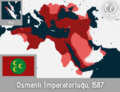 Osmanlı İmparatorluğu'nun en geniş sınırları, 1687.png 6,144 × 4,713; 2.44 MB
-
 Osmanska riket 1683.jpg 1,966 × 1,850; 867 KB
-
 Ottoman 1683.png 280 × 200; 13 KB
-
 OttomanEmpireIn1683 ar.png 1,966 × 1,850; 379 KB
-
 OttomanEmpireIn1683 hu.png 850 × 800; 204 KB
-
 OttomanEmpireIn1683-cy.svg 1,966 × 1,850; 251 KB
-
 OttomanEmpireIn1683-es.svg 1,966 × 1,850; 835 KB
-
 OttomanEmpireIn1683-fr.svg 1,966 × 1,850; 302 KB
-
 OttomanEmpireIn1683-he.png 1,966 × 1,669; 229 KB
-
 OttomanEmpireIn1683-pt.svg 1,966 × 1,850; 240 KB
-
 OttomanEmpireIn1683-ru.png 1,966 × 1,850; 356 KB
-
 OttomanEmpireIn1683-wl.png 1,966 × 1,850; 211 KB
-
 OttomanEmpireIn1683-zh-classical.png 1,966 × 1,850; 442 KB
-
 OttomanEmpireIn1683-zh-hans.svg 1,966 × 1,850; 1.88 MB
-
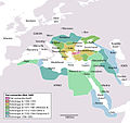
 OttomanEmpireIn1683.png 1,966 × 1,850; 298 KB
-
 OttomanEmpireIn1683tr.png 1,966 × 1,850; 327 KB
-
 OttomanEmpireMain.png 3,597 × 2,581; 1.44 MB
-
 Podolia Eyalet, Ottoman Empire (1683)-ar.svg 960 × 800; 233 KB
-
 Podolia Eyalet, Ottoman Empire (1683)-pt.svg 900 × 750; 186 KB
-
 Podolia Eyalet, Ottoman Empire (1683).svg 900 × 750; 182 KB
-
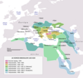
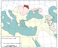
 Territorial changes of the Ottoman Empire 1683.jpg 1,104 × 834; 443 KB
.png)


-ar.svg)
.svg)


-ar.svg)
-pt.svg)
.svg)
