Category:Maps of the power grid in Japan
Media in category "Maps of the power grid in Japan"
The following 14 files are in this category, out of 14 total.
-
 275-kV underground power lines in Nagoya.svg 384 × 288; 5 KB
-
 Central Japan 500-kV grid schematic.svg 900 × 428; 33 KB
-
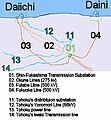 FukushimaGrid.v2.jpg 404 × 437; 41 KB
-
 Hokkaido-Honshu HVDC Link 01.svg 643 × 415; 130 KB
-
 Kii Channel HVDC Link 01.svg 600 × 400; 110 KB
-
 Power grid of Daido Denryoku in 1921.svg 750 × 600; 67 KB
-
 Power grid of Daido Denryoku in 1926.svg 2,100 × 1,500; 148 KB
-
 Power grid of Daido Denryoku in 1938 (50Hz).svg 1,900 × 1,600; 85 KB
-
 Power grid of Daido Denryoku in 1938.svg 2,200 × 2,000; 312 KB
-
 Power Grid of Japan as of 2008.png 779 × 739; 165 KB
-
 Power Grid of Japan J.PNG 780 × 740; 97 KB
-
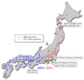
 Power Grid of Japan.svg 2,480 × 2,600; 361 KB
-
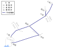
 Power grids of Yahagi Suiryoku 1.svg 1,800 × 1,800; 268 KB
-
 Power grids of Yahagi Suiryoku 2.svg 1,400 × 1,200; 146 KB


.svg)


