Category:Maps of the world with Mercator projection
Media in category "Maps of the world with Mercator projection"
The following 119 files are in this category, out of 119 total.
-
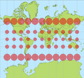
 Tissot indicatrix world map Mercator proj.svg 3,000 × 2,984; 550 KB
-
 Tissot mercator.png 777 × 720; 47 KB
-
 16th century Portuguese Spanish trade routes.png 2,835 × 1,188; 2 MB
-
 16th century Spanish trade routes.png 2,835 × 1,188; 775 KB
-
 1780 Raynal and Bonne Map of the World - Geographicus - Planisphere-bonne-1780.jpg 2,500 × 1,698; 1.32 MB
-

-
 1801 Cary Map of the World on Mercator Projection - Geographicus - WorldMerc-cary-1801.jpg 5,000 × 4,451; 7.15 MB
-

-

-

-
-

-
 201103 carte ROHM.jpg 1,417 × 854; 407 KB
-
 2022-11-02 at 00-19-06 Wikidata Query Service.png 1,279 × 992; 768 KB
-
 2ltivrk.jpg 813 × 224; 93 KB
-
 A plat of all the world - Norman B. Leventhal Map Center at the BPL.jpg 2,000 × 1,343; 2.37 MB
-
 Admiralty Chart No 2558 Track chart of the world, Published 1874.jpg 15,560 × 9,183; 40.24 MB
-
 AFI member countries.jpg 1,047 × 650; 62 KB
-
 Anti-homophobic-discrimination.svg 1,575 × 1,101; 531 KB
-
 AT&T Lobby 4.jpg 5,617 × 3,737; 9.8 MB
-
 Atlántico para el mundo.jpg 929 × 585; 133 KB
-
 BAMS Zones of communication.png 1,903 × 1,083; 1.26 MB
-
 Beers Ulster County Atlas Page006-007.jpg 6,997 × 4,681; 6.92 MB
-
 Blank Gomberg World map.png 3,972 × 2,419; 1.54 MB
-
 Blank Map of the World Remastered 2023.png 3,200 × 1,800; 88 KB
-
 Blue Marble Health Map.png 1,967 × 1,234; 727 KB
-
 Brockhaus and Efron Encyclopedic Dictionary b52 544-0.jpg 3,352 × 2,552; 1.72 MB
-
 Brockhaus' Konversations-Lexikon (1892) (14598009557).jpg 1,506 × 2,708; 691 KB
-
 Carl Christian Franz Radefeld, Welt karte in Mercators projektion (FL147409163 2725559).jpg 3,818 × 3,096; 11.26 MB
-
 Carte générale des grandes communications télégraphiques du monde.jpg 7,265 × 5,119; 34.73 MB
-
-
-
 Coefficient de Gini, année de référence variable.png 1,200 × 743; 280 KB
-
 Colored world map.png 1,115 × 1,024; 190 KB
-
-
 Earth surface NGDC 2000.jpg 8,548 × 6,118; 19.12 MB
-
 EB1911 - Map - Fig. 31.—Mercator's Chart of the World (1569).jpg 1,078 × 723; 583 KB
-
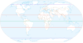 Equator, tropics and polar circles.svg 512 × 261; 617 KB
-
 Expédition de La Pérouse.jpg 12,063 × 8,193; 16.06 MB
-
 First Russian circumnavigation route - ru.svg 1,851 × 1,031; 906 KB
-
 FMIB 47348 World on Mercator's Projection.jpeg 1,691 × 1,271; 553 KB
-
 Fondos oceánicos.jpg 1,772 × 1,289; 2.29 MB
-
 Global plate motion 2008-04-17.jpg 700 × 495; 375 KB
-
 GOPAC Members.png 691 × 442; 89 KB
-
 IALA world distribution.PNG 947 × 505; 94 KB
-
-
 John Biscoe Map 1849.jpg 2,716 × 1,322; 1,001 KB
-
 LA2-Blitz-0103.jpg 2,832 × 1,832; 1.39 MB
-
 Location European Union.svg 999 × 553; 521 KB
-
 Map of Global Minimum Wages per Hour in USD.jpg 1,018 × 644; 93 KB
-
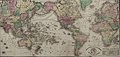
 Map of the world on the Mercator projection. LOC 2005625107.jpg 4,254 × 2,235; 1.23 MB
-
 Map of Vacation Days Around the World.png 1,051 × 683; 213 KB
-

-
 Mare pacificum.png 1,994 × 1,200; 293 KB
-
 Map-Mercator.jpg 758 × 403; 56 KB
-
 Mercator 1569.png 1,158 × 737; 811 KB
-
 Mercator Blank Map World.png 1,433 × 930; 227 KB
-
 Mercator grid.png 532 × 385; 58 KB
-
 Mercator projection SW.jpg 2,058 × 1,746; 1.01 MB
-
 Mercator Projection.svg 1,652 × 1,221; 276 KB
-
-
 Mercator with Tissot's Indicatrices of Distortion.svg 1,600 × 1,600; 528 KB
-
 Mercator-proj.jpg 679 × 724; 434 KB
-
 Mercator-proj.png 679 × 724; 14 KB
-
 Mercator-projection.jpg 2,048 × 1,588; 1.33 MB
-
 MercNormSph enhanced.png 800 × 797; 660 KB
-
 MercNormSph.png 800 × 797; 806 KB
-
 Meyer‘s Zeitungsatlas 010 – Welt-Charte in Mercators Projektion.jpg 7,316 × 6,217; 14.74 MB
-
 Mid-ocean ridge system.gif 1,152 × 701; 500 KB
-
 NetzentwuerfeMercator.png 226 × 209; 7 KB
-
 Normal Mercator map 85deg.jpg 2,400 × 2,400; 915 KB
-

-
 Nova-totius-terrarum-orbis-geographica-ac-hydrographica-tabula.jpg 3,639 × 2,504; 13.02 MB
-
 Oblique Mercator with Tissot's Indicatrices of Distortion.svg 1,600 × 1,600; 612 KB
-
 Pieni 2 0791.jpg 5,039 × 2,552; 3.46 MB
-
 RBiasutti1940mercator.png 676 × 724; 32 KB
-
 Real world map.jpg 2,960 × 2,111; 650 KB
-
 Relief World Map by maps-for-free.jpg 16,384 × 12,544; 39.4 MB
-
 Samuel Dunn, A new chart of the world (FL147409185 2725572).jpg 3,360 × 2,470; 9.36 MB
-
 Samuel John Neele, The world on mercators projection (FL147409218 2725603).jpg 3,396 × 2,329; 7.85 MB
-
 Map-Mercator-Sanson.jpg 709 × 374; 56 KB
-
 Standard map of the World. LOC 00556407.jpg 10,264 × 6,556; 8.44 MB
-
 Stielers Handatlas 1891 05.jpg 4,999 × 4,200; 5.1 MB
-
 StielerWorld.jpeg 2,798 × 2,233; 964 KB
-
 Tectonic plates(Empty).png 3,340 × 2,120; 661 KB
-

-

-

-

-

-
 Trade routes with russia(old).png 1,499 × 907; 815 KB
-
 Unlabeled Renatto Luschan Skin color map.svg 512 × 200; 9.79 MB
-
 Voorbeeld mercator projectie.png 563 × 519; 34 KB
-
 Weddells Wendepunkt 1823.jpg 1,737 × 2,566; 1.85 MB
-
 Where the pound is used.jpg 804 × 584; 152 KB
-
 Wigi map.png 1,334 × 835; 267 KB
-
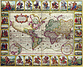
 Willem Blaeu - Nova totius terrarum orbis geographica ac hydrographica tabula.png 6,569 × 4,936; 78.53 MB
-
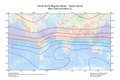
 WMM2010 F MERC.jpg 3,254 × 2,176; 3.24 MB
-
 WMM2010 F MERC.pdf 5,400 × 3,600; 866 KB
-
 World borders mpr.png 2,003 × 1,850; 457 KB
-
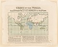
 World cyclopedia 1820.jpg 3,149 × 1,990; 990 KB
-
 World geologic provinces.jpg 1,200 × 637; 115 KB
-
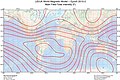
 World Magnetic Declination 2010.pdf 5,400 × 3,600; 865 KB
-
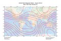
 World Magnetic Inclination 2010.pdf 5,400 × 3,600; 828 KB
-
 World map (Mercator projection) Pacific-centric.svg 720 × 661; 713 KB
-
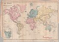 World Map 1855.jpg 6,701 × 4,763; 2.74 MB
-
 World map blank - half of human live inside this circle.svg 1,100 × 750; 316 KB
-
 World map blank shorelines semiwikimapia.svg 1,100 × 750; 358 KB
-
 World map blank shorelines.svg 1,100 × 750; 358 KB
-
 World map blank-Americas centred.svg 1,100 × 750; 325 KB
-
 World Map without Borders, Oceans or Antarctica.png 2,137 × 1,241; 67 KB
-
 World tectonic plate map large.png 1,024 × 700; 254 KB
-
 World-map.svg 600 × 400; 562 KB
-
 World2Hires filled mercator.svg 220 × 171; 11.45 MB
-
 Worldheight.jpg 1,780 × 1,192; 1.5 MB
-
 Worldmap-Mercator.jpg 500 × 350; 23 KB
-
 WrightMoxon-PlatofAlltheWorld-1657-large.jpg 2,800 × 1,880; 1 MB
-
 Y-DNA migration.png 1,496 × 876; 365 KB
-
 康庭睿画的世界地图第三版.jpg 3,177 × 1,967; 866 KB


_-_Geographicus_-_World-colton-1852.jpg)


_(14598009557).jpg)
.jpg)


.jpg)


%27_(11178587694).jpg)


.jpg)
.jpg)


_(14586826677).jpg)
_(14770949284).jpg)
_(14770952964).jpg)
_(14772967582).jpg)
_(14773309195).jpg)
.png)


_Pacific-centric.svg)


.jpg)
.png)