Category:Maps showing 1863
| ← 1860 1861 1862 1863 1864 1865 1866 1867 1868 1869→ |
English: Maps showing the year 1863 (i.e. history maps)
See also category: 1863 maps. and 1860s maps for more maps showing this year usually created not long after the given year.
See also category: 1863 maps. and 1860s maps for more maps showing this year usually created not long after the given year.
Subcategories
This category has the following 2 subcategories, out of 2 total.
M
Media in category "Maps showing 1863"
The following 15 files are in this category, out of 15 total.
-
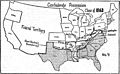 Americana Civil War in America - Map 4.jpg 1,663 × 1,024; 166 KB
-
 Emancipation Proclamation.PNG 1,513 × 983; 54 KB
-
 Morganmap.jpg 433 × 441; 37 KB
-
 Political Evolution of Central America and the Caribbean 1863 na.png 1,000 × 750; 127 KB
-
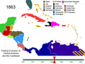 Political Evolution of Central America and the Caribbean 1863.png 1,000 × 750; 155 KB
-
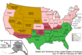 United States 1862-1863-02.png 1,000 × 677; 117 KB
-
 United States 1863-02-1863-03.png 1,000 × 677; 118 KB
-
 United States 1863-03-1863-06.png 1,000 × 677; 119 KB
-
 United States 1863-06-1864-05.png 1,000 × 677; 120 KB
-
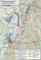 Vicksburg Campaign December 1862-April 1863.pdf 1,200 × 1,777; 4.48 MB
-
 Wpdms arizona new mexico territories 1863 idx.png 264 × 281; 14 KB
-
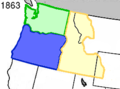 Wpdms washington idaho territories 1863.png 270 × 200; 25 KB
-

-

-


.svg)