Category:Mariä Himmelfahrt (Rückers)
| Object location | | View all coordinates using: OpenStreetMap |
|---|
church building in Rückers, Germany  | |||||
| Upload media | |||||
| Instance of | |||||
|---|---|---|---|---|---|
| Named after | |||||
| Location | Rückers, Flieden, Fulda, Kassel Government Region, Hesse, Germany | ||||
| Heritage designation | |||||
 | |||||
Media in category "Mariä Himmelfahrt (Rückers)"
The following 13 files are in this category, out of 13 total.
-
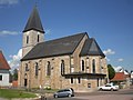
 Katholische Pfarrkirche in Rückers.JPEG 2,816 × 2,112; 3.29 MB
-
 Rückers, Himmelfahrt - Orgelblick.JPG 2,448 × 3,264; 1.79 MB
-
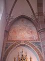 Rückers; Ablassfreske 1451.JPG 2,448 × 3,264; 1.75 MB
-
 Rückers; Gnadenaltar.JPG 2,448 × 3,264; 1.88 MB
-
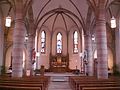 Rückers; Himmelfahrt - Altarblick.JPG 3,264 × 2,448; 2.38 MB
-
 Rückers; Hochkreuz am alten Friedhof hinter der Kirche.JPG 2,448 × 3,264; 1.85 MB
-
 Rückers; Josefsaltar.JPG 2,448 × 3,264; 1.92 MB
-
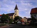
 Rückers; Kirche Mariä Himmelfahrt.JPG 3,264 × 2,448; 2.06 MB
-
 Rückers; Kriegerdenkmal an der Kirche.JPG 3,264 × 2,448; 2.8 MB
-
 Rückers; Orgel.JPG 2,448 × 3,264; 1.88 MB
-
 Rückers; Taufstein.JPG 2,448 × 3,264; 1.69 MB
-
 Wallfahrtskirche "Mariä Himmelfahrt" in Rückers.png 1,914 × 1,762; 6.38 MB
-
 Wallfahrtskirche Mariä Himmelfahrt Rückers - Tafel.JPG 2,348 × 1,796; 2.98 MB


