Category:Mason Street (Boston, Massachusetts)
| Object location | | View all coordinates using: OpenStreetMap |
|---|
Subcategories
This category has the following 2 subcategories, out of 2 total.
W
Media in category "Mason Street (Boston, Massachusetts)"
The following 14 files are in this category, out of 14 total.
-
 1814 Common Boston map Hales detail BPL 12926.png 1,065 × 745; 1.48 MB
-
 1814 Common Boston map Hales.png 765 × 691; 1,012 KB
-
 1822 new wards Boston ColumbianCentinel 3April detail2.png 314 × 522; 208 KB
-
 1824 riding Roulstone Boston ColumbianCentinel April21.png 357 × 559; 182 KB
-
 1826 EssexSt Boston map byFuller Annin Smith BPL10344 detail.png 805 × 712; 1.06 MB
-
 1829 BedfordSt Boston map byStimpson BPL12254 detail.png 803 × 711; 1.14 MB
-
 1861 WinterSt map Boston Dutton BPL11002 detail.png 804 × 712; 1,010 KB
-
 1869 MasonSt Nanitz map Boston detail BPL10490.png 1,069 × 742; 1.13 MB
-
 1869 WestSt Nanitz map Boston detail BPL10490.png 1,065 × 743; 1.59 MB
-
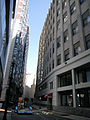
 2012 MasonSt Boston Massachusetts 4791.jpg 3,648 × 2,736; 7.53 MB
-
 2012 MasonSt Boston Massachusetts 4792.jpg 2,736 × 3,648; 8.1 MB
-
 BoylstonSt Boston1829 Stimpson.png 611 × 624; 776 KB
-
 Massachusetts Medical College ca1824 MasonSt Boston.png 550 × 326; 303 KB
-
 MedicalCollege building MasonSt Boston.png 445 × 294; 323 KB


