Category:Maurice River Township, New Jersey
township of New Jersey   | |||||
| Upload media | |||||
| Instance of | |||||
|---|---|---|---|---|---|
| Named after | |||||
| Location | Cumberland County, New Jersey | ||||
| Inception |
| ||||
| Population |
| ||||
| Area |
| ||||
| Elevation above sea level |
| ||||
| official website | |||||
 | |||||
Subcategories
This category has the following 9 subcategories, out of 9 total.
Media in category "Maurice River Township, New Jersey"
The following 17 files are in this category, out of 17 total.
-
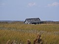 Abandoned Shack near East Point Lighthouse Crop (1663309359).jpg 3,072 × 2,304; 1.44 MB
-
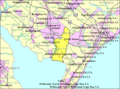 Census Bureau map of Maurice River Township, New Jersey.png 575 × 425; 61 KB
-
 Combination atlas map of Cumberland County, New Jersey LOC 2007626883-25.jpg 2,238 × 2,664; 1.11 MB
-
 Combination atlas map of Cumberland County, New Jersey LOC 2007626883-34.jpg 2,148 × 2,689; 826 KB
-
 Combination atlas map of Cumberland County, New Jersey LOC 2007626883-34.tif 2,148 × 2,689; 16.53 MB
-
 Fall color show maurice river.jpg 3,234 × 2,226; 4.09 MB
-
 FIshing Shack (1700449772).jpg 3,072 × 2,304; 1.41 MB
-
 Fishing SHack crop (1699594231).jpg 1,389 × 1,738; 625 KB
-
 Grass and Fishing Shack (1700505394).jpg 3,072 × 2,304; 1.1 MB
-
 Intersection Route 47 and Route 55 Terminus -Bamboo Art Garden.jpg 3,264 × 1,901; 2.49 MB
-
 Manumuskin River New Jersey.jpg 2,856 × 2,142; 4.39 MB
-
 Map of Cumberland County highlighting Maurice River Township.png 549 × 499; 10 KB
-
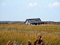
 Marsh Grass and Abandoned Shack (1664163110).jpg 3,072 × 2,304; 1.56 MB
-
 Maurice River (1664213506).jpg 3,072 × 2,304; 1.45 MB
-
 Maurice River Township ES.jpg 3,343 × 2,653; 3.13 MB
-
 Rainbow over Cumberland Pond.jpg 400 × 300; 13 KB
-
 Shack by East Point Lighthouse (1700578170).jpg 3,072 × 2,304; 1.26 MB
.jpg)


.jpg)
.jpg)
.jpg)


.jpg)
.jpg)


.jpg)