Category:May 2007 in Lincolnshire
Deutsch: Bilder, die im Mai 2007 in Lincolnshire aufgenommen worden sind. Bitte beachten Sie, dass dies weder das Datum des Uploads noch das Datum des Scannens eines Fotos ist.
English: Images/pictures taken in Lincolnshire during May 2007. Note this is not the date of the upload, nor the date a photo was scanned.
Español: Fotografías o imágenes tomadas en Lincolnshire durante mayo 2007. No es la fecha de subida ni escaneo, sino la fecha en que las fotografías o imágenes se crearon.
Esperanto: Bildoj faritaj en Lincolnshire en majo 2007. Tio ne estas la dato, kiam la bildoj estis alŝutitaj aŭ skanitaj.
Français : Photographies ou images prises en Lincolnshire durant mai 2007. Ce n'est pas la date du téléchargement ou du scan.
Galego: Fotografías ou imaxes tomadas en Lincolnshire durante maio 2007. Non é a data de subida nin escaneamento, senón a data na que se crearon as fotografías ou imaxes.
Italiano: Fotografie o immagini scattate a Lincolnshire nel maggio 2007. Nota bene: la data non si riferisce né a quella di upload né a quella in cui la foto è stata digitalizzata.
Norsk bokmål: Bilder tatt i Lincolnshire i løpet av mai 2007. Merk at dette ikke er datoen for opplasting, eller når et bilde har blitt skannet.
Norsk nynorsk: Bilete teke i Lincolnshire i løpet av mai 2007. Merk at dette ikkje er datoen for opplasting, eller når eit bilete har vorte skanna.
Русский: Изображения, сделанные в Lincolnshire в течение май 2007 (не дата загрузки изображения).
Українська: Зображення, зроблені в Lincolnshire протягом травень 2007. Зауважте, що це не дата завантаження чи дата сканування фотографії.
| May 2006 | ← | May 2007 | → | May 2008 | |||||||
| Jan | Feb | Mar | Apr | May | Jun | Jul | Aug | Sep | Oct | Nov | Dec |
| 124 | 104 | 205 | 386 | 171 | 183 | 108 | 119 | 122 | 168 | 32 | 99 |
|---|---|---|---|---|---|---|---|---|---|---|---|
Subcategories
This category has the following 6 subcategories, out of 6 total.
0
2
Media in category "May 2007 in Lincolnshire"
The following 165 files are in this category, out of 165 total.
-
 Barn on Horkstow Wolds - geograph.org.uk - 419899.jpg 640 × 394; 101 KB
-
 New Holland Pier - geograph.org.uk - 420763.jpg 640 × 369; 120 KB
-
 Entrance to Polling Station - geograph.org.uk - 422865.jpg 557 × 640; 136 KB
-
 Bus Shelter, Spilsby - geograph.org.uk - 422175.jpg 640 × 480; 75 KB
-
 Fenland Junction - geograph.org.uk - 434374.jpg 640 × 480; 78 KB
-
 New Library - geograph.org.uk - 597578.jpg 640 × 480; 87 KB
-
 Posh Wash .. - geograph.org.uk - 426380.jpg 640 × 480; 101 KB
-
 "Wath House" - geograph.org.uk - 426400.jpg 640 × 480; 106 KB
-

-
 Spar Shop on Burgh Road Skegness - geograph.org.uk - 426445.jpg 640 × 480; 112 KB
-
 7 St Valentine's Way, Skegness - geograph.org.uk - 426456.jpg 640 × 480; 112 KB
-
 The Bridge across Barton Haven - geograph.org.uk - 724029.jpg 640 × 425; 103 KB
-
 Stripy Crops - geograph.org.uk - 427997.jpg 640 × 480; 63 KB
-
 Branston Hall - geograph.org.uk - 428026.jpg 640 × 480; 61 KB
-
 Bridleway to Binbrook - geograph.org.uk - 435360.jpg 426 × 640; 354 KB
-
 Bridleway to Parsonage Farm - geograph.org.uk - 436822.jpg 426 × 640; 415 KB
-
 Lurking signpost - geograph.org.uk - 436830.jpg 640 × 420; 372 KB
-
 Wolds road - geograph.org.uk - 435369.jpg 640 × 523; 319 KB
-
 Skidbrooke cum Saltfleet - geograph.org.uk - 432043.jpg 640 × 427; 60 KB
-
 Killingholme high light - geograph.org.uk - 475612.jpg 640 × 512; 87 KB
-
 Ulceby Chapel - geograph.org.uk - 435409.jpg 640 × 426; 160 KB
-
 Ulceby Seventh Day Adventist Church - geograph.org.uk - 431149.jpg 640 × 434; 132 KB
-
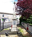 Ulceby War Memorial.jpg 555 × 640; 216 KB
-
 Ulceby High Street - geograph.org.uk - 435399.jpg 640 × 426; 114 KB
-
 Entrance - geograph.org.uk - 431086.jpg 640 × 426; 182 KB
-
 The Pond, Wootton - geograph.org.uk - 431059.jpg 640 × 426; 108 KB
-
 Young Moor-Hen in Waters' Edge Park - geograph.org.uk - 435228.jpg 640 × 583; 241 KB
-
 Market Place, Barton-Upon-Humber - geograph.org.uk - 436158.jpg 640 × 396; 107 KB
-
 Skegness Pier - geograph.org.uk - 549062.jpg 480 × 640; 90 KB
-
 Old School, Tetney - geograph.org.uk - 456508.jpg 640 × 480; 96 KB
-
 The Horn, High Street, Messingham, Lincolnshire.jpg 808 × 686; 527 KB
-
 Looking towards Turton's Covert - geograph.org.uk - 419889.jpg 640 × 426; 94 KB
-

-
 Windmill tower from Princes St - geograph.org.uk - 420061.jpg 640 × 480; 133 KB
-
-

-
 Inside St Mary's Church, Pinchbeck - geograph.org.uk - 422321.jpg 480 × 640; 104 KB
-
 Wesleyan Chapel, Old Bolingbroke - geograph.org.uk - 421767.jpg 640 × 480; 91 KB
-
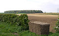 Looking towards Turton's Covert - geograph.org.uk - 423687.jpg 640 × 387; 121 KB
-
 Chalk feature - geograph.org.uk - 430105.jpg 640 × 480; 122 KB
-
 "Golf Ball" - geograph.org.uk - 430559.jpg 640 × 480; 79 KB
-
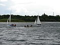 Sailing at North Hykeham Sailing Club - geograph.org.uk - 437528.jpg 640 × 480; 156 KB
-
 Church Tower, Wootton - geograph.org.uk - 431112.jpg 480 × 640; 158 KB
-
 Wootton Church - geograph.org.uk - 431075.jpg 640 × 480; 158 KB
-
 Wootton Churchyard - geograph.org.uk - 431096.jpg 640 × 426; 169 KB
-
 Wootton Churchyard - geograph.org.uk - 431125.jpg 640 × 426; 190 KB
-
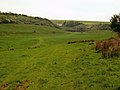
 Between Potterhanworth and Bardney - geograph.org.uk - 434023.jpg 480 × 640; 159 KB
-
 Potterhanworth Fen - geograph.org.uk - 434019.jpg 640 × 480; 106 KB
-
 The Viking Way footpath near Woodhall Spa - geograph.org.uk - 434330.jpg 640 × 481; 171 KB
-
 Bridleways near Southrey - geograph.org.uk - 434041.jpg 640 × 480; 80 KB
-
 Broad Beans and Southrey Wood - geograph.org.uk - 434046.jpg 640 × 480; 167 KB
-
 Farm track near Southrey. - geograph.org.uk - 434038.jpg 640 × 462; 148 KB
-
 Farmland near Southrey - geograph.org.uk - 434035.jpg 640 × 475; 132 KB
-
 Potterhanworth Fen - geograph.org.uk - 434005.jpg 640 × 475; 141 KB
-

-
 Wet sheep near Stixwould - geograph.org.uk - 434358.jpg 640 × 480; 183 KB
-
 The Viking Way footpath in Woodhall Spa - geograph.org.uk - 434316.jpg 640 × 480; 144 KB
-
 The Viking Way footpath near Woodhall Spa - geograph.org.uk - 434340.jpg 640 × 480; 189 KB
-
 The Village Limits - geograph.org.uk - 434342.jpg 640 × 473; 133 KB
-

-
 Fishtoft - geograph.org.uk - 437691.jpg 640 × 427; 73 KB
-
 Fishtoft War Memorial - geograph.org.uk - 437693.jpg 427 × 640; 82 KB
-
 New Park Wood - geograph.org.uk - 448548.jpg 2,816 × 1,880; 3.78 MB
-
 Road through New Park Wood - geograph.org.uk - 448535.jpg 2,816 × 1,880; 4.37 MB
-
 Bridleway to Thoresway - geograph.org.uk - 452375.jpg 640 × 427; 72 KB
-
 Croxby view - geograph.org.uk - 451310.jpg 640 × 427; 57 KB
-
 Thoresway - geograph.org.uk - 451331.jpg 640 × 427; 68 KB
-
 A18, Scunthorpe - geograph.org.uk - 440386.jpg 640 × 461; 169 KB
-
 From Fen Bridge - geograph.org.uk - 443721.jpg 640 × 427; 78 KB
-

-
 Eastgate, Deeping St James - geograph.org.uk - 443035.jpg 640 × 427; 96 KB
-
 Local business on Station Road - geograph.org.uk - 443081.jpg 640 × 427; 136 KB
-
 Prior's Meadow, Deeping St James - geograph.org.uk - 443046.jpg 640 × 427; 128 KB
-
 Signs at the level crossing - geograph.org.uk - 443093.jpg 640 × 578; 120 KB
-
 Eyes Right - geograph.org.uk - 441111.jpg 640 × 480; 113 KB
-
 Winding lane to Yarburgh - geograph.org.uk - 457739.jpg 640 × 480; 106 KB
-
 St Mary & All Saints South Kyme Lincolnshire.JPG 2,048 × 1,536; 592 KB
-
 A Profusion of Geese - geograph.org.uk - 444268.jpg 640 × 493; 185 KB
-
 2007 May 26 - Nocton Hall Remains.jpeg 2,048 × 1,536; 278 KB
-
 Doorway, near Wainfleet St Mary - geograph.org.uk - 446489.jpg 480 × 640; 85 KB
-

-
 Pizza Jim - geograph.org.uk - 456755.jpg 490 × 640; 161 KB
-
 Spencer Molloy, Electricals Shop - geograph.org.uk - 446248.jpg 640 × 477; 174 KB
-
 Austacre Farm - geograph.org.uk - 448520.jpg 2,816 × 1,880; 3.81 MB
-
 Bonby - geograph.org.uk - 453775.jpg 640 × 428; 91 KB
-
 St Mary's Catholic Church, Brigg - geograph.org.uk - 453782.jpg 640 × 428; 80 KB
-
 The Old School House - geograph.org.uk - 448528.jpg 2,816 × 1,880; 3.24 MB
-
 2007 May 26 - RAF Nocton Hall Hospital.jpeg 2,048 × 1,536; 481 KB
-
 Bardney Road New Park Wood - geograph.org.uk - 448543.jpg 2,816 × 1,880; 3.98 MB
-
 New Park Wood - geograph.org.uk - 448538.jpg 2,782 × 1,857; 5.16 MB
-
 Lone Tree - geograph.org.uk - 450739.jpg 640 × 480; 44 KB
-
 Footpath towards Grimsby - geograph.org.uk - 450810.jpg 640 × 427; 65 KB
-
 Scartho farmland - geograph.org.uk - 450807.jpg 640 × 427; 66 KB
-
 Black Springs - geograph.org.uk - 451326.jpg 640 × 427; 52 KB
-
 Thoresway Hall - geograph.org.uk - 451342.jpg 640 × 427; 70 KB
-
 Another Glimpse Of Home - geograph.org.uk - 421223.jpg 640 × 480; 124 KB
-
 Asleep on the job - geograph.org.uk - 436827.jpg 640 × 426; 433 KB
-
 Barlings Lane - geograph.org.uk - 421214.jpg 640 × 427; 80 KB
-
 Barn off Cow Gate - geograph.org.uk - 420719.jpg 640 × 427; 109 KB
-
 Black Miles Track, Billingborough Fen - geograph.org.uk - 421440.jpg 640 × 427; 106 KB
-
 Brough Roads - geograph.org.uk - 441874.jpg 640 × 450; 49 KB
-
 Converted Signal Box at Gunby - geograph.org.uk - 426350.jpg 640 × 480; 72 KB
-
 Cottages on the road to Binbrook Hall - geograph.org.uk - 436824.jpg 640 × 371; 302 KB
-
 Country road near Lound - geograph.org.uk - 420129.jpg 640 × 427; 138 KB
-
 Cow Gate - geograph.org.uk - 420737.jpg 640 × 427; 93 KB
-
 Eastville railway station.jpg 640 × 480; 78 KB
-
 Farforth Road - geograph.org.uk - 449285.jpg 640 × 480; 133 KB
-
 Farforth Road Junction, Maidenwell - geograph.org.uk - 449300.jpg 640 × 480; 102 KB
-
 Farmland near Lound - geograph.org.uk - 420120.jpg 640 × 427; 88 KB
-
 Firsby curve 2 - geograph.org.uk - 446090.jpg 640 × 480; 122 KB
-
 Firsby curve 3 - geograph.org.uk - 446099.jpg 640 × 480; 84 KB
-
 Firsby curve 4 - geograph.org.uk - 446111.jpg 640 × 480; 68 KB
-
 Firsby curve 5 - geograph.org.uk - 446124.jpg 640 × 480; 81 KB
-
 Firsby curve 6 - geograph.org.uk - 446143.jpg 640 × 480; 86 KB
-
 Footbridge and footpath by Falls Farm - geograph.org.uk - 443767.jpg 640 × 480; 100 KB
-
 Footbridge at Little Wisbeach - geograph.org.uk - 420608.jpg 640 × 427; 122 KB
-
 Footpath and footbridge by Falls Farm - geograph.org.uk - 443768.jpg 640 × 480; 92 KB
-
 Footpath at Blacksmith's Lane, East Keal - geograph.org.uk - 443719.jpg 640 × 480; 138 KB
-
 Footpath by Cow Gate House - geograph.org.uk - 421424.jpg 640 × 427; 91 KB
-

-
 Glimpse of Home - geograph.org.uk - 421104.jpg 640 × 480; 103 KB
-
 Great Tows - geograph.org.uk - 435351.jpg 640 × 426; 293 KB
-
 Gunnerby sub-station - geograph.org.uk - 450827.jpg 640 × 427; 63 KB
-
 Hidden Trig point - geograph.org.uk - 436833.jpg 640 × 426; 269 KB
-
 Home And Away - geograph.org.uk - 449226.jpg 640 × 480; 93 KB
-
 Home On The Hill - geograph.org.uk - 449141.jpg 640 × 480; 96 KB
-
 Home Through The Hedge - geograph.org.uk - 445908.jpg 640 × 480; 132 KB
-
 Lonely Bluebell - geograph.org.uk - 435345.jpg 426 × 640; 328 KB
-
 Low down - geograph.org.uk - 435281.jpg 640 × 426; 291 KB
-
 Luddington to Garthorpe road - geograph.org.uk - 443445.jpg 640 × 480; 159 KB
-
 Maidenwell - geograph.org.uk - 449278.jpg 640 × 480; 159 KB
-
 New Station Restaurants - geograph.org.uk - 421180.jpg 640 × 427; 52 KB
-
 Old railway stile - geograph.org.uk - 460416.jpg 640 × 480; 168 KB
-
 Oslear's Lane - geograph.org.uk - 449260.jpg 640 × 480; 120 KB
-
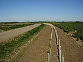
 Ouse Mere Lode - geograph.org.uk - 420678.jpg 640 × 427; 132 KB
-
 Pinchbeck Station Site - geograph - 423945.jpg 640 × 480; 61 KB
-
 Plaque at Ulceby War Memorial.jpg 640 × 474; 146 KB
-
 River Welland from Fen Bridge. - geograph.org.uk - 443733.jpg 640 × 427; 81 KB
-
 Road in the Lincolnshire Wolds - geograph.org.uk - 435300.jpg 640 × 584; 382 KB
-
 Small wood near Manthorpe - geograph.org.uk - 420107.jpg 640 × 427; 149 KB
-
 St Jude's Mission Church, New Leake - geograph.org.uk - 445480.jpg 480 × 640; 101 KB
-
 Stile by the Steeping River - geograph.org.uk - 438609.jpg 640 × 480; 99 KB
-
 Stixwould Station on the Water Rail Way - geograph.org.uk - 434225.jpg 640 × 472; 112 KB
-
 Stixwould-railway-station-by-Alan-Murray-Rust.jpg 640 × 474; 113 KB
-
 Switchbacks - geograph.org.uk - 435292.jpg 640 × 434; 310 KB
-
 Track To Grange Farm - geograph.org.uk - 420191.jpg 640 × 480; 76 KB
-
 Tumby Woodside Station.jpg 640 × 480; 95 KB
-
 View from Clarey's Bridge, Thorpe Bank - geograph.org.uk - 445881.jpg 640 × 480; 103 KB
-
 Wolds View - geograph.org.uk - 445949.jpg 640 × 480; 126 KB
-
 Bellwater Drain - geograph.org.uk - 445509.jpg 640 × 480; 63 KB
-
 Bellwater Drain 2 - geograph.org.uk - 445498.jpg 640 × 480; 97 KB
-
 Bellwater Drain 3 - geograph.org.uk - 445518.jpg 640 × 480; 51 KB
-
 Bellwater Drain, Thorpe Fen - geograph.org.uk - 446363.jpg 640 × 480; 68 KB
-
 Bunker, Clamp Gate Bridge - geograph.org.uk - 426725.jpg 640 × 480; 71 KB
-
 Farm Road by the Bellwater Drain - geograph.org.uk - 446387.jpg 640 × 480; 51 KB
-
 Field - geograph.org.uk - 431067.jpg 640 × 272; 93 KB
-
 Fishtoft Road - geograph.org.uk - 437689.jpg 640 × 427; 57 KB
-
 Fossdyke from West Bank - geograph.org.uk - 425217.jpg 640 × 427; 65 KB
-
 Ing Lands - geograph.org.uk - 431968.jpg 640 × 427; 71 KB
-
 Lincoln Reds - geograph.org.uk - 432106.jpg 640 × 427; 85 KB
-
 Nosey Cow^ - geograph.org.uk - 437397.jpg 640 × 480; 112 KB
-
 Pastoral Agriculture, Southfield Farm - geograph.org.uk - 426722.jpg 640 × 480; 72 KB
-
 Potterhanworth cattle - geograph.org.uk - 425051.jpg 640 × 427; 77 KB
-
 Pylons - geograph.org.uk - 437695.jpg 640 × 427; 47 KB
-
 Red Bull - geograph.org.uk - 432117.jpg 640 × 427; 80 KB


