Category:May 2008 in County Antrim
English: Images taken in County Antrim, Northern Ireland in this month of 2008 (not the date of the upload).
| Jan | Feb | Mar | Apr | May | Jun | Jul | Aug | Sep | Oct | Nov | Dec | ||
| ← | 127 | 62 | 31 | 62 | 48 | 137 | 38 | 15 | 42 | 11 | 8 | 12 | → |
|---|
Media in category "May 2008 in County Antrim"
The following 47 files are in this category, out of 47 total.
-
 "Paddy's Pier", Portrush - geograph.org.uk - 813950.jpg 640 × 479; 76 KB
-
 "The Pilgrim's Steps", Portrush - geograph.org.uk - 813933.jpg 640 × 479; 77 KB
-
 "The wee dock", Portrush - geograph.org.uk - 813946.jpg 640 × 294; 43 KB
-
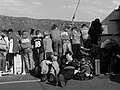
 The Rathlin ferry (4) - geograph.org.uk - 795666.jpg 640 × 418; 61 KB
-
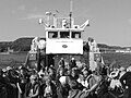
 Rathlin Island Ferry (1) - geograph.org.uk - 817231.jpg 640 × 543; 218 KB
-
 Rathlin Island Ferry (2) - geograph.org.uk - 817237.jpg 640 × 524; 227 KB
-
 Rathlin Island Ferry (3) - geograph.org.uk - 817244.jpg 480 × 640; 228 KB
-
 Rathlin Island Ferry (4) - geograph.org.uk - 817256.jpg 640 × 480; 198 KB
-
 Rathlin Island Ferry (5) - geograph.org.uk - 818710.jpg 640 × 480; 206 KB
-
-

-
 A sign of the times - geograph.org.uk - 864554.jpg 640 × 360; 69 KB
-
 Ballynoe Lane near Antrim - geograph.org.uk - 824463.jpg 640 × 394; 107 KB
-
 Ballynure, County Antrim - geograph.org.uk - 787368.jpg 640 × 480; 72 KB
-
 Cars at Ballintoy harbour - geograph.org.uk - 820148.jpg 640 × 480; 240 KB
-
 Church manse - geograph.org.uk - 814889.jpg 640 × 480; 149 KB
-
 Church manse(converted) - geograph.org.uk - 814886.jpg 640 × 480; 144 KB
-
 Community Hall - geograph.org.uk - 814899.jpg 640 × 480; 109 KB
-
 Converted Manse - geograph.org.uk - 792604.jpg 640 × 360; 68 KB
-
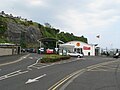
 Council Offices - geograph.org.uk - 795640.jpg 640 × 360; 58 KB
-
 Country road - geograph.org.uk - 792612.jpg 640 × 360; 96 KB
-
 Derelict farm building - geograph.org.uk - 793801.jpg 640 × 360; 108 KB
-
 End of road - geograph.org.uk - 807791.jpg 640 × 480; 223 KB
-
 Entrance to country estate - geograph.org.uk - 792627.jpg 640 × 360; 93 KB
-
 Farm buildings - geograph.org.uk - 792631.jpg 640 × 360; 64 KB
-
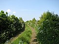 Farm lane - geograph.org.uk - 814951.jpg 640 × 480; 136 KB
-
 Forest road - geograph.org.uk - 807772.jpg 640 × 480; 98 KB
-
 Former coal barge, Antrim - geograph.org.uk - 802692.jpg 635 × 423; 98 KB
-
 Gid Point and Portbraddan - geograph.org.uk - 819987.jpg 640 × 480; 236 KB
-
 Information plaque - geograph.org.uk - 814906.jpg 640 × 480; 198 KB
-
 Lisburn Railway Station - geograph.org.uk - 806158.jpg 640 × 424; 92 KB
-
 Moss-side Presbyterian Church - geograph.org.uk - 814944.jpg 640 × 480; 76 KB
-
 Moss-side Primary School - geograph.org.uk - 814936.jpg 640 × 480; 119 KB
-
 Moss-side Primary School - geograph.org.uk - 814940.jpg 640 × 480; 135 KB
-
 Moycraig Wood - geograph.org.uk - 807801.jpg 640 × 480; 165 KB
-

-

-
 Railway near Whitehead (2) - geograph.org.uk - 786791.jpg 581 × 389; 79 KB
-
 Railway near Whitehead - geograph.org.uk - 786762.jpg 640 × 419; 101 KB
-
 Railway sign near Whitehead (1) - geograph.org.uk - 786665.jpg 640 × 432; 92 KB
-
 Railway sign near Whitehead (2) - geograph.org.uk - 786685.jpg 640 × 449; 130 KB
-

-
 Tree lined laneway - geograph.org.uk - 793797.jpg 640 × 360; 116 KB
-
 Two fishing boats at Portrush - geograph.org.uk - 813183.jpg 640 × 427; 62 KB
-

-
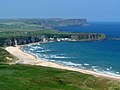
 White Park Bay - geograph.org.uk - 820002.jpg 640 × 480; 250 KB
-
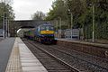 Whiteabbey railway station in 2008.jpg 640 × 426; 98 KB


_-_geograph.org.uk_-_795666.jpg)
_-_geograph.org.uk_-_817231.jpg)
_-_geograph.org.uk_-_817237.jpg)
_-_geograph.org.uk_-_817244.jpg)
_-_geograph.org.uk_-_817256.jpg)
_-_geograph.org.uk_-_818710.jpg)


_-_geograph.org.uk_-_814886.jpg)


_-_geograph.org.uk_-_818541.jpg)
_-_geograph.org.uk_-_818545.jpg)
_-_geograph.org.uk_-_786791.jpg)

_-_geograph.org.uk_-_786665.jpg)
_-_geograph.org.uk_-_786685.jpg)
_-_geograph.org.uk_-_795847.jpg)


_2001_Scania_L94UB_Wright_Solar,_31_May_2008.jpg)

