Category:May 2015 in the East Riding of Yorkshire
Ceremonial counties of England: Bedfordshire · Berkshire · Cambridgeshire · Cheshire · Cornwall · Cumbria · Derbyshire · Devon · Dorset · Durham · East Riding of Yorkshire · East Sussex · Essex · Gloucestershire · Greater London · Greater Manchester · Hampshire · Herefordshire · Hertfordshire · Kent · Lancashire · Leicestershire · Lincolnshire · Merseyside · Norfolk · North Yorkshire · Northamptonshire · Northumberland · Nottinghamshire · Oxfordshire · Shropshire · Somerset · South Yorkshire · Staffordshire · Suffolk · Surrey · Tyne and Wear · Warwickshire · West Midlands · West Sussex · West Yorkshire · Wiltshire · Worcestershire
City-counties: Bristol ·
Former historic counties:
Other former counties:
City-counties: Bristol ·
Former historic counties:
Other former counties:
Deutsch: Bilder, die im Mai 2015 in the East Riding of Yorkshire aufgenommen worden sind. Bitte beachten Sie, dass dies weder das Datum des Uploads noch das Datum des Scannens eines Fotos ist.
English: Images/pictures taken in the East Riding of Yorkshire during May 2015. Note this is not the date of the upload, nor the date a photo was scanned.
Español: Fotografías o imágenes tomadas en the East Riding of Yorkshire durante mayo 2015. No es la fecha de subida ni escaneo, sino la fecha en que las fotografías o imágenes se crearon.
Esperanto: Bildoj faritaj en the East Riding of Yorkshire en majo 2015. Tio ne estas la dato, kiam la bildoj estis alŝutitaj aŭ skanitaj.
Français : Photographies ou images prises en the East Riding of Yorkshire durant mai 2015. Ce n'est pas la date du téléchargement ou du scan.
Galego: Fotografías ou imaxes tomadas en the East Riding of Yorkshire durante maio 2015. Non é a data de subida nin escaneamento, senón a data na que se crearon as fotografías ou imaxes.
Italiano: Fotografie o immagini scattate a the East Riding of Yorkshire nel maggio 2015. Nota bene: la data non si riferisce né a quella di upload né a quella in cui la foto è stata digitalizzata.
Norsk bokmål: Bilder tatt i the East Riding of Yorkshire i løpet av mai 2015. Merk at dette ikke er datoen for opplasting, eller når et bilde har blitt skannet.
Norsk nynorsk: Bilete teke i the East Riding of Yorkshire i løpet av mai 2015. Merk at dette ikkje er datoen for opplasting, eller når eit bilete har vorte skanna.
Русский: Изображения, сделанные в the East Riding of Yorkshire в течение май 2015 (не дата загрузки изображения).
Українська: Зображення, зроблені в the East Riding of Yorkshire протягом травень 2015. Зауважте, що це не дата завантаження чи дата сканування фотографії.
| May 2014 | ← | May 2015 | → | May 2016 | |||||||
| Jan | Feb | Mar | Apr | May | Jun | Jul | Aug | Sep | Oct | Nov | Dec |
| 27 | 233 | 373 | 66 | 218 | 51 | 98 | 47 | 25 | 61 | 18 | 30 |
|---|---|---|---|---|---|---|---|---|---|---|---|
Subcategories
This category has the following 3 subcategories, out of 3 total.
Media in category "May 2015 in the East Riding of Yorkshire"
The following 200 files are in this category, out of 215 total.
(previous page) (next page)-
 A growing crop on Routh Carrs (geograph 4474538).jpg 4,608 × 3,456; 4.91 MB
-
 A Jaguar on Keldgate, Beverley (geograph 4476345).jpg 2,448 × 1,624; 1.63 MB
-
 A Jaguar on Keldgate, Beverley (geograph 4476349).jpg 2,448 × 1,624; 1.87 MB
-

-
 A166-B1248 junction, Wetwang, E Yorks (geograph 4457525).jpg 640 × 460; 180 KB
-
 Access denied (geograph 4458543).jpg 1,024 × 768; 124 KB
-
 Acer Palmatum 'Red Pygmy'.jpg 4,928 × 3,264; 9.95 MB
-
 Air Commodore Ronald Berry CBE DSO DFC ^ Bar - geograph.org.uk - 4467037.jpg 2,448 × 1,624; 1.16 MB
-
 Approaching Asselby (geograph 4505921).jpg 800 × 533; 149 KB
-
 Ashdene Close off Gorton Road (geograph 4478023).jpg 2,448 × 1,624; 1.3 MB
-
 Auxiliary Fire Service Vehicle on Gorton Road (geograph 4478193).jpg 2,448 × 1,624; 1.42 MB
-
 Beach near Danes Dyke, E Yorks - geograph.org.uk - 4494741.jpg 640 × 458; 213 KB
-
 Beauty Therapy Unlimited on Main Street, Willerby (geograph 4479269).jpg 2,448 × 1,624; 1.34 MB
-
 Bend on Willerby Low Road near Haggs Lane (geograph 4481216).jpg 2,448 × 1,624; 1.89 MB
-
 Beverley & East Riding Golf Club (geograph 4476355).jpg 2,448 × 1,624; 1.09 MB
-
 Beverley & East Riding Golf Club (geograph 4476359).jpg 2,448 × 1,624; 1.27 MB
-
 Beverley Westwood IMG 1338.JPG - panoramio.jpg 1,600 × 886; 767 KB
-
 Beverley Westwood IMG 1342.JPG - panoramio.jpg 1,600 × 971; 682 KB
-
 Beverley Westwood IMG 1344.JPG - panoramio.jpg 1,600 × 971; 886 KB
-
 Beverley Westwood IMG 1348.JPG - panoramio.jpg 1,600 × 966; 1,013 KB
-
 Bluebell near the A1079 south of Beverley (geograph 4464866).jpg 495 × 640; 162 KB
-
 Brickyard Lane (geograph 4480977).jpg 1,024 × 768; 314 KB
-
 Broad Dale, near Fimber, E Yorks - geograph.org.uk - 4455843.jpg 640 × 476; 210 KB
-
 Broadgate towards Walkington (geograph 4476376).jpg 2,448 × 1,624; 1.54 MB
-
 Burton Bushes bluebells IMG 1362.JPG - panoramio.jpg 1,600 × 891; 832 KB
-
 Burton Bushes IMG 1365 - panoramio.jpg 1,600 × 1,067; 1,012 KB
-
 Bus stop on Bempton Lane - geograph.org.uk - 4482715.jpg 640 × 421; 60 KB
-
 Businesses on Main Street, Willerby (geograph 4479227).jpg 2,448 × 1,624; 1.13 MB
-
 Café at Danes Dyke, E Yorks - geograph.org.uk - 4494679.jpg 640 × 485; 190 KB
-
 Carr Lane at Ash Grove, Willerby (geograph 4478952).jpg 2,448 × 1,624; 800 KB
-
 Carr Lane at Willow Court, Willerby (geograph 4478950).jpg 2,448 × 1,624; 1.05 MB
-
 Carr Lane towards Willerby Square (geograph 4478948).jpg 2,448 × 1,624; 1.27 MB
-
 Carr Lane towards Willerby Square (geograph 4478954).jpg 2,448 × 1,624; 1.23 MB
-
 Carr Lane towards Willerby Square (geograph 4478995).jpg 2,448 × 1,624; 1.24 MB
-
 Carr Lane towards Willerby Square (geograph 4479003).jpg 2,448 × 1,624; 1.47 MB
-
 Church clock, Fridaythorpe (geograph 4457666).jpg 513 × 640; 191 KB
-
 Church of St Mary, Fimber, E Yorks - geograph.org.uk - 4457702.jpg 480 × 640; 178 KB
-
 Cottage on Main Street, Willerby (geograph 4479306).jpg 2,448 × 1,624; 1.63 MB
-
 Cottingham Sports Pavilion IMG 0857.jpg - panoramio.jpg 1,067 × 1,600; 504 KB
-
 Cowdale Plantation near Wetwang, E Yorks (geograph 4457156).jpg 640 × 427; 188 KB
-
 Cultivating near Fimber, E Yorks - geograph.org.uk - 4455867.jpg 640 × 427; 183 KB
-
 Dent Road, Bricknell Avenue Estate, East Riding of Yorkshire (geograph 6845082).jpg 2,396 × 1,670; 507 KB
-

-
 Dropping down into Elloughton Dale (geograph 4505264).jpg 640 × 427; 50 KB
-
 Dry stream bed at Danes Dyke, E Yorks - geograph.org.uk - 4494653.jpg 427 × 640; 204 KB
-

-
 Entering Wawne on Sutton Road (geograph 4474213).jpg 4,588 × 3,428; 4.89 MB
-
 Entrance to the track to Brantingham (geograph 4505226).jpg 640 × 427; 80 KB
-
 Farm access road and Skifting's Clump (geograph 4458535).jpg 1,024 × 768; 352 KB
-
 Farmland off Willerby Low Road (geograph 4481673).jpg 2,448 × 1,624; 2.42 MB
-
 Field by Fimber roundabout, E Yorks - geograph.org.uk - 4455859.jpg 640 × 427; 196 KB
-
 Flats on Kingston Road, Willerby (geograph 4478200).jpg 2,448 × 1,624; 1.04 MB
-
 Footbridge in Dyke Wood, East Yorks - geograph.org.uk - 4494671.jpg 640 × 503; 203 KB
-
 Footpath near Wetwang, E Yorks (geograph 4457478).jpg 479 × 640; 168 KB
-
 Former Methodist Church, Willerby Square (geograph 4479220).jpg 2,448 × 1,624; 1.2 MB
-
 Former quarry in Skiftings Clump (geograph 4458517).jpg 1,024 × 768; 380 KB
-
 Friday in Fridaythorpe, (E Yorks) (geograph 4457670).jpg 640 × 444; 205 KB
-
 Fridaythorpe Field, East Yorks - geograph.org.uk - 4456336.jpg 447 × 640; 194 KB
-
 Gameslack Farm, Near Wetwang, E Yorks (geograph 4457471).jpg 640 × 459; 216 KB
-
 Garages to the rear of The Parkway (geograph 4478479).jpg 2,448 × 1,624; 1.16 MB
-
 Gorton Road at Kenwardly Road (geograph 4478042).jpg 2,448 × 1,624; 1.56 MB
-
 Gorton Road at Kenwardly Road (geograph 4478175).jpg 2,448 × 1,624; 1.63 MB
-
 Gorton Road towards Kingston Road, Willerby (geograph 4478021).jpg 2,448 × 1,624; 1.58 MB
-
 Gorton Road towards Kingston Road, Willerby (geograph 4478195).jpg 2,448 × 1,624; 1.34 MB
-
 H B C Wheelie Bin Cleaning Van (geograph 4478944).jpg 2,448 × 1,624; 1.41 MB
-
 Haggs Lane off Willerby Low Road (geograph 4481222).jpg 2,448 × 1,624; 1.32 MB
-
 Haltemprice & Howden Conservative Association (geograph 4479238).jpg 2,448 × 1,624; 1.3 MB
-
 Haltemprice Bowling Club, Anlaby (geograph 4478017).jpg 2,448 × 1,624; 1.07 MB
-
 Haltemprice Leisure Centre, Anlaby (geograph 4477960).jpg 2,448 × 1,624; 1.95 MB
-
 Harper Dale, East Yorks (geograph 4457077).jpg 640 × 427; 187 KB
-
 Hawthorne Avenue at Carr Lane, Willerby (geograph 4478945).jpg 2,448 × 1,624; 1.76 MB
-
 Hawthorne Avenue off Carr Lane, Willerby (geograph 4478855).jpg 2,448 × 1,624; 1.15 MB
-
 Hawthorne Avenue off Carr Lane, Willerby (geograph 4478862).jpg 2,448 × 1,624; 1.12 MB
-
 High Hunsley Circuit crossing Elloughton Dale (geograph 4505296).jpg 640 × 427; 101 KB
-
 Hill Top Farm and Cumbrian Way junction (geograph 4474201).jpg 3,550 × 2,623; 2.61 MB
-
 Holderness Drain from Meaux Bridge (geograph 4474252).jpg 3,400 × 4,566; 6.76 MB
-
 Holm Dale, East Yorks - central section - geograph.org.uk - 4457075.jpg 460 × 640; 167 KB
-
 Holm Dale, East Yorks - northern end (geograph 4457074).jpg 640 × 432; 197 KB
-
 Holm Dale, East Yorks, - upper end (geograph 4457073).jpg 543 × 640; 211 KB
-
 Holm Dale, East Yorks, southern end (geograph 4457080).jpg 640 × 427; 173 KB
-
 Holm Dale, near Fridaythorpe, E Yorks (geograph 4456358).jpg 640 × 437; 218 KB
-
 Houses on Gorton Road (geograph 4478029).jpg 2,448 × 1,624; 1.61 MB
-
 Houses on Main Street, Willerby (geograph 4479242).jpg 2,448 × 1,624; 1.56 MB
-
 Houses on Main Street, Willerby (geograph 4479274).jpg 2,448 × 1,624; 925 KB
-
 Houses on Main Street, Willerby (geograph 4479328).jpg 2,448 × 1,624; 1.43 MB
-
 Houses on Main Street, Willerby (geograph 4479902).jpg 2,448 × 1,624; 1.83 MB
-
 Houses on Oak Hill, Willerby (geograph 4479916).jpg 2,448 × 1,624; 1.49 MB
-
 Houses on The Parkway off Kingston Road (geograph 4478462).jpg 2,448 × 1,624; 1.38 MB
-
 Houses on York Gardens, Willerby (geograph 4479908).jpg 2,448 × 1,624; 1.61 MB
-
 Industrial estate (geograph 4480989).jpg 1,024 × 768; 96 KB
-
 John Gray Court off Main Street, Willerby (geograph 4479264).jpg 2,448 × 1,624; 1.36 MB
-
 Joiners Lane, Wetwang, E Yorks (geograph 4457501).jpg 640 × 474; 225 KB
-
 Keldgate, Beverley (geograph 4476346).jpg 2,448 × 1,624; 1.47 MB
-
 Kingston Road, Willerby (geograph 4478197).jpg 2,448 × 1,624; 1.27 MB
-
 Knedlington Old Hall (geograph 4505926).jpg 800 × 533; 146 KB
-
 Layby and entrance to Middlethorpe Farm (geograph 4497934).jpg 1,024 × 768; 129 KB
-
 Leaves in Dyke Wood, E Yorks - geograph.org.uk - 4494665.jpg 530 × 640; 208 KB
-
 Locomotive at Yorkshire Wolds Railway.jpg 3,264 × 2,448; 2.88 MB
-
 Low Farm on Willerby Low Road (geograph 4481621).jpg 2,448 × 1,624; 2.45 MB
-
 Luthers Rise off Main Street, Willerby (geograph 4479967).jpg 2,448 × 1,624; 2.01 MB
-
 Main Street, Wetwang (geograph 4457484).jpg 640 × 427; 191 KB
-
 Main Street, Willerby (geograph 4479225).jpg 2,448 × 1,624; 1.1 MB
-
 Main Street, Willerby (geograph 4479971).jpg 2,448 × 1,624; 1.81 MB
-
 Main Street, Willerby at Willerby Low Road (geograph 4481065).jpg 2,448 × 1,624; 1.62 MB
-
 Manor Farm and pond, Fimber, E Yorks - geograph.org.uk - 4457704.jpg 640 × 621; 165 KB
-
 Meaux Lane over Routh Carrs (geograph 4474546).jpg 3,069 × 2,300; 2.31 MB
-
 Meaux Road from Meaux Bridge (geograph 4474257).jpg 4,608 × 3,456; 5.94 MB
-
 Meaux Road toward Meaux Bridge (geograph 4474233).jpg 4,608 × 3,456; 4.53 MB
-
 Meaux Road Wawne Hill Farm to the left (geograph 4474227).jpg 4,548 × 3,376; 4.94 MB
-
 Megson Way off Broadgate near Beverley (geograph 4476394).jpg 2,448 × 1,624; 1.16 MB
-
 Melton railway bridge carrying Brickyard Lane (geograph 4480982).jpg 1,024 × 551; 108 KB
-
 Millington IMG 1176.JPG - panoramio.jpg 1,600 × 976; 709 KB
-
 Millington IMG 1186.JPG - panoramio.jpg 1,402 × 1,600; 694 KB
-
 Millington IMG 1247.CR2 - panoramio.jpg 1,106 × 1,600; 835 KB
-
 Millington IMG 1252.CR2 - panoramio.jpg 1,600 × 1,067; 732 KB
-
 Millington Wood IMG 1254.CR2 - panoramio.jpg 1,067 × 1,600; 861 KB
-
 Millington, nice day for a ride IMG 1258.JPG - panoramio.jpg 1,600 × 982; 571 KB
-
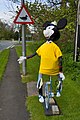 Minnie-cycle, Wetwang, E Yorks (geograph 4457492).jpg 427 × 640; 206 KB
-

-
 Near Fimber Nab, E Yorks - geograph.org.uk - 4455850.jpg 640 × 427; 192 KB
-
 North East Lodge on Willerby Low Road (geograph 4481390).jpg 2,448 × 1,624; 2.1 MB
-
 Overton Avenue near Collynson Close (geograph 4478491).jpg 2,448 × 1,624; 712 KB
-
 Overton Avenue towards Carr Lane, Willerby (geograph 4478498).jpg 2,448 × 1,624; 1.42 MB
-
 Parking sign, Wetwang, E Yorks (geograph 4457517).jpg 640 × 447; 211 KB
-
 Passageway to the rear of The Parkway (geograph 4478467).jpg 2,448 × 1,624; 1.69 MB
-
 Picnic tables at Fimber picnic site (geograph 4487771).jpg 1,024 × 768; 282 KB
-
 Plaque to Christine Jensen MBE (geograph 4502314).jpg 2,000 × 1,452; 317 KB
-
 Plaque to Mary Denness (geograph 4502322).jpg 2,000 × 1,500; 278 KB
-
 Plaque to Yvonne Blenkinsop (geograph 4502319).jpg 2,000 × 1,443; 271 KB
-
 Pond near Fimber, E Yorks - geograph.org.uk - 4455826.jpg 468 × 640; 207 KB
-
 Potato field, near Fimber Nab, E Yorks - geograph.org.uk - 4455855.jpg 640 × 427; 181 KB
-
 Potato planting near Fimber, E Yorks - geograph.org.uk - 4457663.jpg 640 × 449; 194 KB
-

-
 Primrose Villa on Main Street, Willerby (geograph 4479889).jpg 2,448 × 1,624; 2.57 MB
-
 Pulsatilla vulgaris - Burnby Hall.jpg 4,817 × 3,099; 7.59 MB
-
 Road through Elloughton Dale into Elloughton (geograph 4505318).jpg 640 × 427; 89 KB
-
 Roadworks on Main Street, Willerby (geograph 4479289).jpg 2,448 × 1,624; 1.76 MB
-
 Roger Garth off Overton Avenue (geograph 4478485).jpg 2,448 × 1,624; 1.28 MB
-
 Sheep near Harper Dale, E Yorks (geograph 4457170).jpg 607 × 640; 231 KB
-
 Shops on Main Street, Willerby (geograph 4479222).jpg 2,448 × 1,624; 1.05 MB
-
 Small wooded area on Main Street, Willerby (geograph 4481061).jpg 2,448 × 1,624; 1.82 MB
-
 Source of Elloughton Beck (geograph 4505302).jpg 640 × 427; 119 KB
-
 South East Lodge on Willerby Low Road (geograph 4481395).jpg 2,448 × 1,624; 2.39 MB
-
 Southfield Road in Wetwang, East Yorks (geograph 4457511).jpg 640 × 449; 192 KB
-
 Southfield Road, Wetwang, E Yorks (geograph 4457507).jpg 640 × 447; 208 KB
-
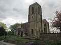 St Peter's Parish Church Wawne (geograph 4474219).jpg 4,608 × 3,456; 3.52 MB
-
 Stumpery - Burnby Hall.jpg 4,799 × 3,068; 12.47 MB
-
 Taxus Baccata 'Fastigiata Aurea'.jpg 3,264 × 4,928; 13.48 MB
-
 The Beeches on Main Street, Willerby (geograph 4479319).jpg 2,448 × 1,624; 1.55 MB
-
 The junction of Overton Avenue and Hawthorne Avenue (geograph 4478854).jpg 2,448 × 1,624; 1.43 MB
-
 The Sandpiper public house on Monks Way East (geograph 4480965).jpg 1,024 × 768; 87 KB
-
 The Star Inn on Main Street, Willerby (geograph 4479279).jpg 2,448 × 1,624; 1.12 MB
-
 The Star Inn on Main Street, Willerby (geograph 4479282).jpg 985 × 1,423; 449 KB
-
 Timbers blocking the end of Brickyard Lane (geograph 4480972).jpg 1,024 × 768; 288 KB
-
 Tour de Yorkshire 2015 - Day 1 (17154442119).jpg 800 × 1,200; 333 KB
-
 Tour de Yorkshire 2015, stage 2 Selby to York - geograph.org.uk - 4457300.jpg 4,000 × 2,248; 2.26 MB
-
 Tour de Yorkshire bike on Megson Way (geograph 4476390).jpg 2,448 × 1,624; 2 MB
-
 Tour de Yorkshire bunting on Broadgate, Walkington (geograph 4476532).jpg 2,448 × 1,624; 1.35 MB
-
 Tour de Yorkshire bunting on Cartwright Lane (geograph 4464972).jpg 2,448 × 1,624; 1.76 MB
-
 Tour de Yorkshire bunting on Cartwright Lane (geograph 4464983).jpg 2,448 × 1,624; 1.36 MB
-
 Towards Fimber Grange, E Yorks - geograph.org.uk - 4455830.jpg 463 × 640; 177 KB
-
 Tulipe 'Apricot Foxx'.jpg 4,095 × 3,065; 4.65 MB
-
 Tulipe 'Ballerina'.jpg 4,217 × 3,072; 5.84 MB
-
 Tulipe 'Banja Luka'.jpg 3,941 × 3,131; 4.1 MB
-
 Tulipe 'Davenport'.jpg 4,928 × 3,264; 6.5 MB
-
 Tulipe 'Doll's Minuet'.jpg 4,383 × 2,738; 4.33 MB
-
 Tulipe 'Flaming Parrot'.jpg 4,328 × 3,153; 4.78 MB
-
 Tulipe 'Fly Away'.jpg 3,912 × 2,909; 4.22 MB
-
 Tulipe 'Golden Artist'.jpg 4,679 × 2,995; 4 MB
-
 Tulipe 'HuisTen Bosch'.jpg 3,096 × 2,517; 3.26 MB
-
 Tulipe 'Mariette'.jpg 4,573 × 2,729; 4.89 MB
-
 Tulipe 'Rem's Favorite'.jpg 4,865 × 3,171; 5.79 MB
-
 Tulipe blanche - Burnby Hall.jpg 3,739 × 3,115; 4.2 MB
-
 Tulipe jaune - Burnby Hall.jpg 4,331 × 3,062; 4.2 MB
-
 Tulipes 'Princess Irene'.jpg 4,928 × 3,264; 6.88 MB
-
 Tulipes roses avec striures vert clair.jpg 4,342 × 3,079; 5.47 MB
-
 Tulipes rouges et jaunes - Burnby Hall.jpg 4,376 × 3,110; 5.5 MB
-

-
 View towards Swanland (geograph 4458563).jpg 1,024 × 768; 158 KB
-
 Village pond, Fridaythorpe, E Yorks - geograph.org.uk - 4457658.jpg 640 × 480; 174 KB
-
 Vote Yorkshire First placard (geograph 4476367).jpg 2,448 × 1,624; 1.22 MB
-
 Water Tower, Swanland (geograph 4495897).jpg 1,280 × 960; 1.05 MB
-
 Welcome to Brough village (geograph 4481002).jpg 1,024 × 749; 119 KB
-
 Welton Wold (geograph 4458526).jpg 1,024 × 768; 237 KB
-
 Welton Wold (geograph 4458555).jpg 1,024 × 768; 141 KB
-
 Whelans of Asselby (geograph 4505918).jpg 800 × 533; 83 KB
-
 White Hill, near Huggate, E Yorks - geograph.org.uk - 4457165.jpg 640 × 427; 216 KB
-
 White House Close on Main Street, Willerby (geograph 4479335).jpg 2,448 × 1,624; 1.22 MB
-
 White House Close on Main Street, Willerby (geograph 4479882).jpg 2,448 × 1,624; 1.12 MB
-
 Wiggo Pasture, Beverley Westwood (geograph 4476371).jpg 2,448 × 1,624; 1.33 MB
-
 Willerby Hall Mews on Main Street, Willerby (geograph 4479324).jpg 2,448 × 1,624; 1.44 MB
-
 Willerby Hall off Main Street, Willerby (geograph 4479315).jpg 2,448 × 1,624; 1.74 MB
-
 Willerby Homes & Gardens Shop (geograph 4479241).jpg 2,448 × 1,624; 1.86 MB
-
 Willerby Low Road at Low Farm (geograph 4481396).jpg 2,448 × 1,624; 1.8 MB
-
 Willerby Low Road towards Cottingham (geograph 4481179).jpg 2,448 × 1,624; 1.87 MB
-
 Willerby Low Road towards Cottingham (geograph 4481185).jpg 2,448 × 1,624; 1.81 MB
-
 Willerby Low Road towards Cottingham (geograph 4481194).jpg 2,448 × 1,624; 1.85 MB
-
 Willerby Low Road towards Cottingham (geograph 4481210).jpg 2,448 × 1,624; 1.01 MB
-
 Willerby Low Road towards Cottingham (geograph 4481236).jpg 2,448 × 1,624; 1.79 MB
-
 Willerby Low Road towards Cottingham (geograph 4481242).jpg 2,448 × 1,624; 1.7 MB
.jpg)
.jpg)
.jpg)
.jpg)
.jpg)
.jpg)


.jpg)
.jpg)
.jpg)

.jpg)
.jpg)
.jpg)
.jpg)


.jpg)
.jpg)

.jpg)


.jpg)

.jpg)
.jpg)
.jpg)
.jpg)
.jpg)
.jpg)
.jpg)

.jpg)

.jpg)

.jpg)

.jpg)


.jpg)
.jpg)
.jpg)
.jpg)

.jpg)

.jpg)
.jpg)
.jpg)
_(geograph_4457670).jpg)

.jpg)
.jpg)
.jpg)
.jpg)
.jpg)
.jpg)
.jpg)
.jpg)
.jpg)
.jpg)
.jpg)
.jpg)
.jpg)
.jpg)
.jpg)
.jpg)
.jpg)
.jpg)

.jpg)
.jpg)
.jpg)
.jpg)
.jpg)
.jpg)
.jpg)
.jpg)
.jpg)
.jpg)
.jpg)
.jpg)
.jpg)
.jpg)
.jpg)
.jpg)
.jpg)
.jpg)
.jpg)


.jpg)
.jpg)
.jpg)
.jpg)
.jpg)
.jpg)

.jpg)
.jpg)
.jpg)
.jpg)
.jpg)
.jpg)


.jpg)
.jpg)

.jpg)
.jpg)
.jpg)
.jpg)
.jpg)
.jpg)
.jpg)
.jpg)
.jpg)


.jpg)

.jpg)
.jpg)
.jpg)
.jpg)
.jpg)
.jpg)
.jpg)
.jpg)
.jpg)
.jpg)
.jpg)


.jpg)
.jpg)
.jpg)
.jpg)
.jpg)
.jpg)
.jpg)

.jpg)
.jpg)
.jpg)
.jpg)


.jpg)
.jpg)

.jpg)
.jpg)
.jpg)
.jpg)
.jpg)
.jpg)

.jpg)
.jpg)
.jpg)
.jpg)
.jpg)
.jpg)
.jpg)
.jpg)
.jpg)
.jpg)
.jpg)
.jpg)
.jpg)