Category:Mears Ashby
village and civil parish in Northamptonshire, United Kingdom  | |||||
| Upload media | |||||
| Instance of | |||||
|---|---|---|---|---|---|
| Location | North Northamptonshire, Northamptonshire, East Midlands, England | ||||
 | |||||
Subcategories
This category has the following 2 subcategories, out of 2 total.
M
S
- Sywell Reservoir (14 F)
Media in category "Mears Ashby"
The following 28 files are in this category, out of 28 total.
-
 Bakehouse Lane - geograph.org.uk - 3930977.jpg 640 × 480; 64 KB
-
 Beside Sywell Wood - geograph.org.uk - 5601973.jpg 480 × 640; 77 KB
-
 Bridleway near Sywell - geograph.org.uk - 5601971.jpg 480 × 640; 76 KB
-
 Entrance to Mears Ashby - geograph.org.uk - 4170306.jpg 640 × 466; 70 KB
-
 Footpath exit - geograph.org.uk - 5601984.jpg 480 × 640; 126 KB
-
 Former Sheep Wash, below Sywell Reservoir - geograph.org.uk - 4390355.jpg 1,333 × 1,000; 1.46 MB
-
 Highfield Road, Mears Ashby - geograph.org.uk - 2583548.jpg 3,072 × 2,304; 3.24 MB
-
 Lady's Lane, Mears Ashby - geograph.org.uk - 2583524.jpg 2,000 × 1,500; 835 KB
-
 Mears Ashby - geograph.org.uk - 5547048.jpg 640 × 480; 428 KB
-
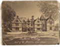 Mears Ashby Hall.png 1,115 × 860; 1.5 MB
-
 Mears Ashby phone box - geograph.org.uk - 5601985.jpg 480 × 640; 64 KB
-
 Mears Ashby, Glebe Road - geograph.org.uk - 5547062.jpg 640 × 480; 456 KB
-
 Near Wood Lodge Farm - geograph.org.uk - 5601969.jpg 480 × 640; 118 KB
-

-
 Sywell Country Park - geograph.org.uk - 1904997.jpg 640 × 480; 110 KB
-
 Sywell Country Park - geograph.org.uk - 1906319.jpg 640 × 480; 101 KB
-
 Sywell Country Park - geograph.org.uk - 1908139.jpg 640 × 480; 57 KB
-
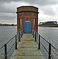 Sywell Reservoir bridge to valve tower - geograph.org.uk - 4390300.jpg 1,000 × 1,015; 962 KB
-
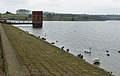 Sywell Reservoir dam and valve tower - geograph.org.uk - 4390266.jpg 1,588 × 1,000; 1.3 MB
-
 Sywell Reservoir Pump House - geograph.org.uk - 4390359.jpg 1,395 × 1,000; 1.19 MB
-
 The former vicarage, Mears Ashby - geograph.org.uk - 2583542.jpg 2,000 × 1,486; 890 KB
-
 The War Memorial, Mears Ashby - geograph.org.uk - 2583530.jpg 1,509 × 2,000; 1.26 MB
-
 Towards Mears Ashby - geograph.org.uk - 5601980.jpg 480 × 640; 70 KB
-
 Towards Mears Ashby - geograph.org.uk - 5601982.jpg 480 × 640; 83 KB
-
 Unnamed Road near Mears Ashby - geograph.org.uk - 5547034.jpg 640 × 480; 416 KB
-
 Wellingborough Road, Mears Ashby - geograph.org.uk - 2583622.jpg 2,000 × 1,495; 647 KB
-
 Farmland - geograph.org.uk - 148038.jpg 640 × 480; 93 KB
-
 Hardwick Lodge - geograph.org.uk - 149636.jpg 640 × 480; 113 KB


