Category:Melbourne, Derbyshire
market town and civil parish in South Derbyshire District, Derbyshire, England  | |||||
| Upload media | |||||
| Instance of | |||||
|---|---|---|---|---|---|
| Location | South Derbyshire, Derbyshire, East Midlands, England | ||||
| Population |
| ||||
| Said to be the same as | Melbourne (Wikimedia duplicated page, civil parish) | ||||
 | |||||
Subcategories
This category has the following 11 subcategories, out of 11 total.
C
J
- John Hair & Son brewery (5 F)
K
M
- Melbourne Castle (7 F)
- Melbourne railway station (3 F)
P
S
- Spirit Vaults (2 F)
W
- Whistlewood Common (55 F)
Media in category "Melbourne, Derbyshire"
The following 200 files are in this category, out of 360 total.
(previous page) (next page)-

-
 'Maintain social distance' in Melbourne - geograph.org.uk - 6685728.jpg 1,600 × 1,200; 580 KB
-
 12 Church Street, Melbourne.jpg 1,024 × 768; 203 KB
-
 16-18 Potter Street, Melbourne.jpg 1,024 × 768; 180 KB
-
 17 and 18 Market Place, Melbourne.jpg 1,024 × 768; 175 KB
-
 26-28 Potter Street, Melbourne.jpg 1,024 × 768; 167 KB
-
 35-37 Castle Street - geograph.org.uk - 2417445.jpg 1,280 × 959; 491 KB
-
 4 and 6 High Street, Melbourne.jpg 1,024 × 768; 199 KB
-
 43and45 Castle Road Melbourne.jpg 1,056 × 1,732; 346 KB
-
 50-54 Potter Street - geograph.org.uk - 2417465.jpg 1,280 × 959; 555 KB
-
 55-61 Castle Street, Melbourne.jpg 1,024 × 768; 151 KB
-
 56 Potter Street, Melbourne (geograph 7063735).jpg 1,024 × 768; 140 KB
-
 58-60 Potter Street, Melbourne.jpg 1,024 × 768; 155 KB
-
 65 Church Street, Melbourne.jpg 1,024 × 768; 176 KB
-
 7 miles to Derby - geograph.org.uk - 4625220.jpg 800 × 549; 157 KB
-
 A country track - geograph.org.uk - 5488740.jpg 2,000 × 1,333; 2.44 MB
-
 A few trees along a drain, north of Wilson - geograph.org.uk - 6685950.jpg 1,600 × 900; 350 KB
-
 A handy tree stump - geograph.org.uk - 5388023.jpg 600 × 800; 169 KB
-
 A road to Kings Newton - geograph.org.uk - 5488742.jpg 2,000 × 1,333; 2.23 MB
-
 A stubble field - geograph.org.uk - 5488758.jpg 2,000 × 1,333; 2.06 MB
-
 A truly rural picture - geograph.org.uk - 5488808.jpg 2,000 × 1,333; 3.09 MB
-
 Access path to Route 6 (Cloud Trail) - geograph.org.uk - 3374326.jpg 640 × 427; 66 KB
-
 An old boiler - geograph.org.uk - 5700883.jpg 1,280 × 960; 645 KB
-
 Ashby Road by the Melbourne Arms - geograph.org.uk - 1829642.jpg 640 × 480; 92 KB
-
 B587 near Melbourne - geograph.org.uk - 251028.jpg 640 × 480; 77 KB
-
 Back of Woodhouse Farm - geograph.org.uk - 5392106.jpg 5,376 × 3,024; 2.52 MB
-
 Barn in rape - geograph.org.uk - 3929626.jpg 640 × 427; 335 KB
-
 Barrow with manure for sale - geograph.org.uk - 3390736.jpg 640 × 427; 105 KB
-
 Beside Staunton Harold Reservoir - geograph.org.uk - 5390136.jpg 5,376 × 3,024; 2.7 MB
-
 Blackwell Lane - geograph.org.uk - 4666629.jpg 640 × 481; 518 KB
-
 Blackwell Lane, Melbourne - geograph.org.uk - 5387483.jpg 5,376 × 3,024; 2.58 MB
-
 Bluebells in Gorse Covert - geograph.org.uk - 5388031.jpg 600 × 800; 240 KB
-
 Boat House at Tithe Cottage.jpg 1,844 × 1,230; 521 KB
-
 Bog Lane - geograph.org.uk - 3565207.jpg 1,200 × 900; 240 KB
-
-
 Bridge crossing the Cloud Trail - geograph.org.uk - 6525622.jpg 777 × 800; 262 KB
-
 Bridge over the Cloud Trail - geograph.org.uk - 3374319.jpg 640 × 427; 75 KB
-
 Bridge over the Cloud Trail - geograph.org.uk - 5533179.jpg 800 × 599; 176 KB
-
 Bridge over the Cloud Trail north of Wilson - geograph.org.uk - 4064644.jpg 1,600 × 1,200; 833 KB
-
 Bridge over the Cloud Trail, south-east of King's Newton - geograph.org.uk - 6685729.jpg 1,600 × 1,200; 711 KB
-

-
 Bridleway and County Boundary - geograph.org.uk - 4366426.jpg 4,000 × 3,000; 2.71 MB
-
 Bridleway through Stafford's Wood - geograph.org.uk - 1430824.jpg 640 × 480; 88 KB
-
 Bridleway to St Brides - geograph.org.uk - 672402.jpg 640 × 429; 93 KB
-
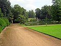 Broad walkway and pond at Melbourne Hall gardens - geograph.org.uk - 3199801.jpg 3,648 × 2,736; 3.21 MB
-
 Broadstone - geograph.org.uk - 5390729.jpg 800 × 600; 163 KB
-
 Broadstone End - geograph.org.uk - 3530023.jpg 1,200 × 900; 274 KB
-
 Broadstone Lane - geograph.org.uk - 1431548.jpg 480 × 640; 74 KB
-
 Building work beside Station Road, Melbourne - geograph.org.uk - 4064856.jpg 1,600 × 1,200; 474 KB
-
 Burdett House - geograph.org.uk - 1355848.jpg 640 × 480; 75 KB
-
 Bust stop at entrance to old station yard, Melbourne, Derbyshire.jpg 1,952 × 2,592; 778 KB
-
 Calke Road - geograph.org.uk - 3530097.jpg 1,200 × 900; 218 KB
-
 Capsized dinghy on Staunton Harold Reservoir - geograph.org.uk - 3530086.jpg 1,200 × 900; 194 KB
-

-
 Carr Brook - geograph.org.uk - 1809794.jpg 1,200 × 900; 421 KB
-
 Carr Brook at Melbourne Station - geograph.org.uk - 2878316.jpg 1,200 × 900; 397 KB
-
 Carr Brook meets Ramsley Brook at New Bridge - geograph.org.uk - 2878308.jpg 1,200 × 900; 341 KB
-
 Castle Square postbox ref. DE73 1367 - geograph.org.uk - 2417460.jpg 1,280 × 959; 571 KB
-
 Cemetery Chapel, Melbourne.jpg 1,600 × 1,200; 628 KB
-
 Chantry House, Melbourne.jpg 1,024 × 768; 184 KB
-
 Charnwood, Jawbone Lane - geograph.org.uk - 4064863.jpg 1,600 × 1,200; 570 KB
-
 Chestnut Park - geograph.org.uk - 3622125.jpg 1,200 × 900; 182 KB
-

-
 Church Street Melbourne - geograph.org.uk - 528354.jpg 640 × 437; 81 KB
-

-
 Close House, Melbourne, Derbyshire.jpg 5,107 × 3,279; 2.7 MB
-
 Cloud Trail from Trent Lane bridge - geograph.org.uk - 3358863.jpg 640 × 480; 178 KB
-
 Co-op building, Melbourne Market Place - geograph.org.uk - 2417346.jpg 1,280 × 959; 512 KB
-
 Concrete stile - geograph.org.uk - 467614.jpg 640 × 480; 112 KB
-
 Corner Cottage - geograph.org.uk - 3565204.jpg 1,200 × 900; 208 KB
-
 Cottage on Blackwell Lane - geograph.org.uk - 5390184.jpg 800 × 600; 103 KB
-
 Cottage on Station Road - geograph.org.uk - 3557360.jpg 640 × 480; 63 KB
-
 Cottages along Melbourne Lane - geograph.org.uk - 4623192.jpg 800 × 600; 143 KB
-
 Cottages on Potter Street - geograph.org.uk - 2417391.jpg 1,280 × 959; 632 KB
-
 County Boundary sign on B587 - geograph.org.uk - 2086126.jpg 640 × 480; 72 KB
-
 Crossing the Trent on the former Midland Railway bridge - geograph.org.uk - 2769948.jpg 4,000 × 3,000; 4.39 MB
-
 Cycle trail heading south - geograph.org.uk - 3557365.jpg 640 × 480; 105 KB
-
 Cycle trail towards Derby - geograph.org.uk - 3557522.jpg 640 × 480; 86 KB
-
 Cyclist on the Cloud Trail - geograph.org.uk - 4366346.jpg 4,000 × 3,000; 2.36 MB
-
 Cyclists on the Cloud Trail - geograph.org.uk - 3868203.jpg 3,844 × 2,780; 2.58 MB
-
 Derby Hills Farm - geograph.org.uk - 3530066.jpg 1,200 × 900; 96 KB
-

-
 Derbyshire UK parish map highlighting Melbourne.svg 888 × 1,308; 2.35 MB
-
 Dinghies at Staunton Harold Reservoir - geograph.org.uk - 6336058.jpg 5,184 × 2,920; 4.46 MB
-
 Dogleg in the Derby to Melbourne road - geograph.org.uk - 674382.jpg 525 × 640; 109 KB
-
 Dower House, Melbourne.jpg 2,000 × 1,333; 2.01 MB
-
 Driveway from the visitor centre - geograph.org.uk - 1432033.jpg 640 × 480; 68 KB
-
 Dwellings on Potter Street - geograph.org.uk - 2417397.jpg 1,280 × 959; 565 KB
-
 Electricity pole along Blackwell Lane - geograph.org.uk - 6494360.jpg 674 × 800; 100 KB
-
 Emerging crop at Chantry Farm - geograph.org.uk - 6685837.jpg 1,600 × 1,200; 704 KB
-
 English Longhorn cattle at Park Farm - geograph.org.uk - 6493944.jpg 800 × 528; 154 KB
-
 Entering Melbourne - geograph.org.uk - 810888.jpg 640 × 512; 78 KB
-
 Entrance to a business park off Station Road - geograph.org.uk - 6685723.jpg 1,600 × 1,200; 572 KB
-
 Entrance to Forest View off Cockshutt Lane - geograph.org.uk - 5386279.jpg 5,376 × 3,024; 2.18 MB
-
 Entrance to old station yard, Melbourne, Derbyshire.jpg 2,592 × 1,952; 1.31 MB
-
 Entrance to Station Farm - geograph.org.uk - 5533182.jpg 800 × 600; 136 KB
-
 Entrance to Station Yard, Melbourne Derbyshire.jpg 2,592 × 1,952; 1.36 MB
-
 Exchange House, Melbourne.jpg 1,024 × 788; 161 KB
-
 Factory building, Melbourne - geograph.org.uk - 5881583.jpg 480 × 640; 78 KB
-
 Faded road markings - geograph.org.uk - 3374347.jpg 640 × 427; 65 KB
-
 Farm access road crossing Scots Brook - geograph.org.uk - 3530062.jpg 1,200 × 900; 198 KB
-
 Farm bridge over Ramsley Brook - geograph.org.uk - 2878331.jpg 1,200 × 900; 286 KB
-
 Farmland along Ramsley Brook - geograph.org.uk - 6685739.jpg 1,600 × 1,200; 572 KB
-
 Farmland at Broadstone Lane End - geograph.org.uk - 1431885.jpg 640 × 480; 80 KB
-
 Farmland near Park Farm - geograph.org.uk - 6493937.jpg 800 × 736; 242 KB
-
 Farmland near the River Trent - geograph.org.uk - 3557372.jpg 640 × 480; 75 KB
-
 Farmland on the east bank of Carr Brook - geograph.org.uk - 6685909.jpg 1,600 × 900; 566 KB
-
 Farmland west of a railway underbridge - geograph.org.uk - 6685932.jpg 1,600 × 900; 695 KB
-
 Fergiland - geograph.org.uk - 251032.jpg 640 × 480; 74 KB
-
 Fields and Bridleway near Breedon - geograph.org.uk - 4366418.jpg 4,000 × 3,000; 2.3 MB
-
 Fields to the east of Melbourne - geograph.org.uk - 3390751.jpg 640 × 427; 106 KB
-
 Fire and shadows at Whistlewood common.jpg 2,448 × 3,264; 2.95 MB
-
 Footbridge across Ramsley Brook - geograph.org.uk - 6685924.jpg 1,600 × 900; 408 KB
-
 Footbridge over Cloud Trail - geograph.org.uk - 3357929.jpg 640 × 480; 159 KB
-
 Footpath and Fields near Coppice Nook - geograph.org.uk - 4366443.jpg 4,000 × 3,000; 2.68 MB
-
 Footpath and telegraph poles across a field - geograph.org.uk - 3565181.jpg 1,200 × 900; 126 KB
-
 Footpath near Broadstone Lane - geograph.org.uk - 1431867.jpg 640 × 480; 65 KB
-
 Footpath through a field of brassicas - geograph.org.uk - 5533185.jpg 800 × 600; 179 KB
-
 Footpath through a field of sheep - geograph.org.uk - 6563850.jpg 1,280 × 960; 622 KB
-
 Footpath through a field of wheat - geograph.org.uk - 5390191.jpg 600 × 800; 132 KB
-
 Footpath to Melbourne - geograph.org.uk - 6493903.jpg 677 × 800; 199 KB
-
 Footpath to Wilson - geograph.org.uk - 6493911.jpg 800 × 600; 148 KB
-
 Footpath to Wilson - geograph.org.uk - 6493931.jpg 726 × 800; 220 KB
-
 Foremark Reservoir and the Trent valley - geograph.org.uk - 2056406.jpg 2,048 × 1,536; 1.31 MB
-
 Former HSBC branch, now the Chip & Pin micro-pub - geograph.org.uk - 5386138.jpg 3,024 × 4,083; 1.75 MB
-

-
 Forty Foot Lane at Wilson - geograph.org.uk - 4366371.jpg 4,000 × 3,000; 2.18 MB
-

-
 Gate and Path off Pool Road - geograph.org.uk - 4666576.jpg 640 × 481; 578 KB
-
 Gate on a Footpath - geograph.org.uk - 3600272.jpg 1,200 × 900; 307 KB
-
 Gate on the Cloud Trail - geograph.org.uk - 3929606.jpg 640 × 427; 489 KB
-
 Gates and Stile near The Coppice - geograph.org.uk - 4366494.jpg 4,000 × 3,000; 3.4 MB
-
 Gateway to Pear Tree Cottage - geograph.org.uk - 5390179.jpg 800 × 600; 206 KB
-
 George VI Postbox, Melbourne - geograph.org.uk - 494101.jpg 683 × 1,024; 164 KB
-
 Grassland and Footpath in Melbourne - geograph.org.uk - 3876380.jpg 3,868 × 2,816; 1.69 MB
-
 Hemsley Barn Cottage - geograph.org.uk - 3768767.jpg 1,142 × 857; 474 KB
-
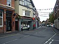
 High Street - geograph.org.uk - 1432094.jpg 640 × 468; 58 KB
-
 High Street Melbourne - geograph.org.uk - 528358.jpg 640 × 437; 79 KB
-
 Historic Heart of Melbourne - geograph.org.uk - 3876388.jpg 3,830 × 2,760; 1.36 MB
-
 House opposite entrance to old station yard, Melbourne, Derbyshire.jpg 2,592 × 1,952; 923 KB
-

-
 King's Newton in South Derbyshire - geograph.org.uk - 6494376.jpg 800 × 645; 179 KB
-
 Lake at Melbourne - panoramio.jpg 3,072 × 2,304; 1.2 MB
-
 Lane near Breach Close - geograph.org.uk - 3877403.jpg 4,000 × 3,000; 2.24 MB
-
 Lawns at Melbourne Hall - geograph.org.uk - 3211173.jpg 3,523 × 2,587; 2.85 MB
-
 Lawns at Melbourne Hall gardens - geograph.org.uk - 3224080.jpg 3,648 × 2,736; 2.61 MB
-
 Leafy avenue - geograph.org.uk - 5392100.jpg 5,376 × 3,024; 3.19 MB
-
 Loading Hay Bales - geograph.org.uk - 3622139.jpg 1,200 × 900; 153 KB
-
 Longhorn Cattle at Park Farm, Melbourne Parks, Derbys - geograph.org.uk - 6336034.jpg 5,184 × 2,920; 1.26 MB
-
 Loop of abandoned road - geograph.org.uk - 3565166.jpg 1,200 × 900; 389 KB
-
 Loughborough University buildings.jpg 3,280 × 2,464; 2.35 MB
-
 Main Street heading east - geograph.org.uk - 3557342.jpg 640 × 480; 78 KB
-
 Market garden near Shaw House - geograph.org.uk - 1430888.jpg 640 × 480; 102 KB
-
 Market Lamp - geograph.org.uk - 2417410.jpg 962 × 1,280; 558 KB
-
 Market Lamp inscription - geograph.org.uk - 2417414.jpg 959 × 1,280; 715 KB
-
 Market Lamp, Melbourne (geograph 7063739).jpg 768 × 1,024; 194 KB
-
 Market Place - geograph.org.uk - 1432151.jpg 640 × 480; 59 KB
-
 Market Place, Melbourne - geograph.org.uk - 1967634.jpg 1,280 × 829; 178 KB
-
 Market Place, Melbourne - geograph.org.uk - 5387105.jpg 5,376 × 3,024; 1.83 MB
-
 Melbourne (Derbyshire) England banner.jpg 2,048 × 293; 526 KB
-
 Melbourne - Hodgkinson's on High Street - geograph.org.uk - 1962857.jpg 1,600 × 1,200; 487 KB
-
 Melbourne - Library - geograph.org.uk - 1962856.jpg 1,600 × 1,175; 423 KB
-
 Melbourne Arms - geograph.org.uk - 1829631.jpg 640 × 480; 54 KB
-
 Melbourne Arms - geograph.org.uk - 5351314.jpg 1,600 × 1,067; 615 KB
-
 Melbourne Arms through the rapeseed - geograph.org.uk - 4764352.jpg 1,600 × 1,067; 420 KB
-
 Melbourne Assembly Rooms and Library - geograph.org.uk - 5387120.jpg 5,376 × 3,024; 2.26 MB
-
 Melbourne Cemetery - geograph.org.uk - 5488745.jpg 2,000 × 1,333; 2.97 MB
-
 Melbourne Church and Hall - geograph.org.uk - 5276153.jpg 2,000 × 1,333; 1.56 MB
-
 Melbourne derbys.jpg 2,592 × 1,944; 1.25 MB
-
 Melbourne fire station - geograph.org.uk - 282021.jpg 640 × 427; 259 KB
-
 Melbourne Guide and Scout Headquarters - geograph.org.uk - 2555394.jpg 1,200 × 900; 170 KB
-
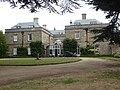 Melbourne Hall - geograph.org.uk - 5881480.jpg 640 × 480; 92 KB
-
 Melbourne Hall - geograph.org.uk - 6455902.jpg 1,280 × 837; 469 KB
-
 Melbourne Hall - geograph.org.uk - 6494307.jpg 800 × 567; 161 KB
-

-
 Melbourne Lane into Ticknall - geograph.org.uk - 3768799.jpg 979 × 734; 380 KB
-
 Melbourne Line railway viaduct – 1 - geograph.org.uk - 5700932.jpg 1,280 × 960; 461 KB
-
 Melbourne Line railway viaduct – 2 - geograph.org.uk - 5700933.jpg 1,280 × 960; 316 KB
-
 Melbourne Line railway viaduct – 3 - geograph.org.uk - 5700936.jpg 1,280 × 960; 342 KB
-
 Melbourne Line railway viaduct – 4 - geograph.org.uk - 5700938.jpg 1,280 × 960; 502 KB
-
 Melbourne Line railway viaduct – 6 - geograph.org.uk - 5700940.jpg 960 × 1,280; 347 KB
-
 Melbourne Line railway viaduct – 7 - geograph.org.uk - 5700944.jpg 1,280 × 800; 308 KB
-
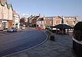
 Melbourne Market Place - geograph.org.uk - 2417342.jpg 1,280 × 959; 441 KB
-
 Melbourne Market place.jpg 640 × 442; 73 KB
-
 Melbourne Mill, Derbyshire.jpg 426 × 640; 79 KB
-
 Melbourne Pool - geograph.org.uk - 4666586.jpg 640 × 481; 457 KB
-
 Melbourne Pool - geograph.org.uk - 4666595.jpg 640 × 481; 484 KB
-
 Melbourne Pool - geograph.org.uk - 5328501.jpg 1,600 × 1,067; 623 KB
-
 Melbourne Post Office - geograph.org.uk - 2086124.jpg 640 × 480; 79 KB
-
 Melbourne Post Office - geograph.org.uk - 2417353.jpg 959 × 1,280; 508 KB
-
 Melbourne So postbox ref DE73 239 - geograph.org.uk - 2678769.jpg 1,280 × 959; 539 KB
-
 Melbourne station road bridge - geograph.org.uk - 3358897.jpg 640 × 480; 148 KB
-
 Melbourne Town Cricket Club - geograph.org.uk - 5388008.jpg 800 × 600; 139 KB
-

-
 Melbourne, Blackwell Lane - geograph.org.uk - 4666630.jpg 640 × 480; 472 KB
-
 Melbourne, Cottage on Blackwell Lane - geograph.org.uk - 4666627.jpg 640 × 481; 576 KB
-
 Melbourne, Derbyshire - St Michael's Church - geograph.org.uk - 6336062.jpg 5,184 × 2,920; 5.55 MB
-
 Melbourne, Derbyshire - The Pool - geograph.org.uk - 6336029.jpg 5,184 × 2,920; 5.79 MB
-

-
 Melbourne, Derbyshire ... Post Office. (5975633230).jpg 3,583 × 3,140; 6.75 MB


.jpg)


_-_geograph.org.uk_-_3374326.jpg)


.jpg)


.jpg)


.jpg)
_England_banner.jpg)