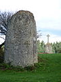
Category:Menhir de Crec'h Ogel
| Object location | | View all coordinates using: OpenStreetMap |
|---|
|
This building is classé au titre des monuments historiques de la France. It is indexed in the base Mérimée, a database of architectural heritage maintained by the French Ministry of Culture, under the reference PA00089624
|
 | |||||
| Upload media | |||||
| Instance of | |||||
|---|---|---|---|---|---|
| Location | Saint-Gilles-Pligeaux, canton of Saint-Nicolas-du-Pélem | ||||
| Heritage designation |
| ||||
 | |||||
Media in category "Menhir de Crec'h Ogel"
The following 2 files are in this category, out of 2 total.
-
 Menhir de Crec'h Ogel à Saint-Gilles-Pligeaux 01.JPG 3,000 × 4,000; 6.68 MB
-
 Menhir de Crec'h Ogel à Saint-Gilles-Pligeaux 02.JPG 4,000 × 3,000; 6.71 MB
