Category:Methodist Episcopal Church of Port Hadlock
|
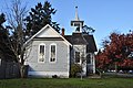
This is a category about a place or building that is listed on the National Register of Historic Places in the United States of America. Its reference number is 83003329. |
| Object location | | View all coordinates using: OpenStreetMap |
|---|
English: The former Methodist Episcopal Church of Port Hadlock, now a private residence, corner of Matheson & Randolph Streets, Port Hadlock-Irondale, Washington, listed on the National Register of Historic Places.
church building in Washington, United States of America  | |||||
| Upload media | |||||
| Instance of | |||||
|---|---|---|---|---|---|
| Location | Washington, Pacific Northwest, Washington, Pacific States Region | ||||
| Heritage designation | |||||
 | |||||
Media in category "Methodist Episcopal Church of Port Hadlock"
The following 5 files are in this category, out of 5 total.
-
 Methodist Episcopal Church of Port Hadlock 01.jpg 4,288 × 2,848; 6.52 MB
-
 Methodist Episcopal Church of Port Hadlock 02.jpg 4,288 × 2,848; 6.43 MB
-
 Methodist Episcopal Church of Port Hadlock 03.jpg 4,288 × 2,848; 6.37 MB
-
 Methodist Episcopal Church of Port Hadlock 04.jpg 4,288 × 2,848; 6.19 MB
-
 Methodist Episcopal Church of Port Hadlock detail 01.jpg 4,288 × 2,848; 5.76 MB


