Category:Mine Head Lighthouse
| Object location | | View all coordinates using: OpenStreetMap |
|---|
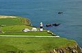
English: Mine Head Lighthouse
lighthouse in Ireland  | |||||
| Upload media | |||||
| Instance of | |||||
|---|---|---|---|---|---|
| Location | County Waterford, Munster, Ireland | ||||
| Inception |
| ||||
| Significant event |
| ||||
| Height |
| ||||
 | |||||
Media in category "Mine Head Lighthouse"
This category contains only the following file.
-
 Mine Head Lighthouse.jpg 662 × 433; 87 KB