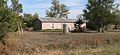
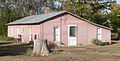
Category:Minor sod house (Rawlins County, Kansas)
| Object location | | View all coordinates using: OpenStreetMap |
|---|
Historic house in Kansas  | |||||
| Upload media | |||||
| Instance of | |||||
|---|---|---|---|---|---|
| Made from material | |||||
| Location | McDonald, Rawlins County, Kansas | ||||
| Street address |
| ||||
| Has use |
| ||||
| Heritage designation |
| ||||
| Inception |
| ||||
 | |||||
Media in category "Minor sod house (Rawlins County, Kansas)"
The following 7 files are in this category, out of 7 total.
-
 Minor sod house from NW 1.JPG 1,757 × 902; 416 KB
-
 Minor sod house from NW long 1.JPG 2,554 × 1,171; 917 KB
-
 Minor sod house from S 1.JPG 2,141 × 1,092; 591 KB
-
 Minor sod house from SE 1.JPG 2,337 × 1,251; 793 KB
-
 Minor sod house from SW 1.JPG 2,195 × 1,124; 726 KB
-
 Minor sod house from SW 2.JPG 2,403 × 1,383; 1,016 KB
-
 Minor sod house from W 1.JPG 2,460 × 1,248; 865 KB


