Category:Mont Gros (Roquebrune)
| Object location | | View all coordinates using: OpenStreetMap |
|---|
mountain | |||||
| Upload media | |||||
| Instance of |
| ||||
|---|---|---|---|---|---|
| Location | Roquebrune-Cap-Martin, canton of Menton-Ouest | ||||
| Mountain range | |||||
| Elevation above sea level |
| ||||
 | |||||
Media in category "Mont Gros (Roquebrune)"
The following 5 files are in this category, out of 5 total.
-
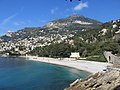 Beach of Roquebrune.jpg 2,816 × 2,112; 2.41 MB
-
Drone - Panorama Monaco.webm 13 s, 1,920 × 1,080; 15.44 MB
-
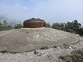 Maginot line cloche on the Mont Gros.jpg 2,816 × 2,112; 2.35 MB
-

-
 Paraglider take off on le Mont-Gros.jpg 2,816 × 2,112; 1.18 MB


