Category:Monti di Bracco
|
Monti di Bracco has an entry on OpenStreetMap (show). |
human settlement in the Italian municipality of Cremia    | |||||
| Upload media | |||||
| Instance of |
| ||||
|---|---|---|---|---|---|
| Location | Cremia, Province of Como, Lombardy, Italy | ||||
| Elevation above sea level |
| ||||
 | |||||
Media in category "Monti di Bracco"
The following 13 files are in this category, out of 13 total.
-
 Buildings at Monti di Bracco, seen from the upper part of the settlement.jpg 6,615 × 3,718; 10.25 MB
-
 Detail of a name plate on a building at Monti di Bracco.jpg 5,544 × 1,780; 1.69 MB
-
 Detail of a VML3 route marker on a building at Monti di Bracco.jpg 7,296 × 5,472; 12.11 MB
-
 Detail of VML3 route marker at Monti di Bracco.jpg 3,648 × 2,176; 1.65 MB
-
 Name plate on a building at Monti di Bracco.jpg 6,368 × 5,064; 6.54 MB
-
 Panoramics of Monti di Bracco, seen from the upper part of the settlement.jpg 6,964 × 3,204; 6.2 MB
-
 Path connecting track to Rifugio La Canua with Monti di Bracco.jpg 5,280 × 5,060; 8.83 MB
-
 Path of VML3 in Monti di Bracco.jpg 7,296 × 5,472; 10.88 MB
-
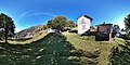 Photosphere at Bracco 01.jpg 5,322 × 2,661; 6.01 MB
-
 Photosphere at Bracco 02.jpg 5,322 × 2,661; 5.85 MB
-
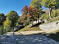 Track approaching Monti di Bracco.jpg 7,296 × 5,472; 10.79 MB
-
 VML3 route marker at Monti di Bracco.jpg 5,888 × 5,148; 5.5 MB
-
 VML3 route marker on a building at Monti di Bracco.jpg 7,296 × 5,472; 7.37 MB


