Category:Moodiesburn
English: Moodiesburn is a residential suburb located in North Lanarkshire, Scotland. It is situated on the A80 road, between Glasgow and Cumbernauld.
village in North Lanarkshire, Scotland, UK  | |||||
| Upload media | |||||
| Instance of | |||||
|---|---|---|---|---|---|
| Location |
| ||||
| Population |
| ||||
 | |||||
Media in category "Moodiesburn"
The following 16 files are in this category, out of 16 total.
-
 Atholl Lane, Moodiesburn - geograph.org.uk - 221747.jpg 640 × 480; 86 KB
-
 Barbeth Moss and the new Motorway - geograph.org.uk - 1622171.jpg 640 × 480; 100 KB
-
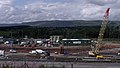 Contractor's Compound - geograph.org.uk - 1497968.jpg 640 × 362; 61 KB
-
 East Muckcroft Farm, near Kirkintilloch - geograph.org.uk - 52493.jpg 640 × 480; 124 KB
-
 Glen Iris, Moodiesburn - geograph.org.uk - 221755.jpg 640 × 480; 73 KB
-
 Leckethill Farm - geograph.org.uk - 153017.jpg 640 × 480; 153 KB
-
 M80 Upgrade at Mollinsburn - geograph.org.uk - 1497949.jpg 640 × 480; 76 KB
-
 Molinsburn motorway junction from the air (geograph 5308137).jpg 480 × 640; 147 KB
-
 Moodiesburn in summer.jpg 4,030 × 2,266; 1,021 KB
-
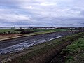
 New bridge over Luggie Water - geograph.org.uk - 1622186.jpg 640 × 480; 95 KB
-
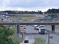
 New Line of Road - geograph.org.uk - 1497982.jpg 640 × 480; 68 KB
-
 New M80 Motorway under construction - geograph.org.uk - 1622181.jpg 640 × 480; 69 KB
-
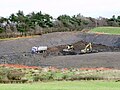 New open cast mine - geograph.org.uk - 1622132.jpg 640 × 480; 89 KB
-
 Remains of East Barrs Farm - geograph.org.uk - 1622137.jpg 640 × 480; 82 KB
-
 Stoneyetts Bowling Club near Moodiesburn - geograph.org.uk - 128132.jpg 640 × 445; 101 KB
-
 The Silver Larch, Moodiesburn - geograph.org.uk - 128119.jpg 640 × 469; 59 KB


.jpg)


