Category:Mount Yoloko
Afrikaans: Die piek van Jolokoberg is 670 meter bo seespieël. Die berg is geleë op die kusvlakte van Ancuabedistrik in Cabo Delgadoprovinsie van noordelike Mosambiek, tussen die 106-roete en Megarumarivier.
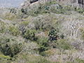
English: The peak of Mt. Yoloko is 670 metres above sea level. The mountain is situated on the coastal plain of Ancuabe District in Cabo Delgado province, northern Mozambique, between route 106 and the Megaruma River. Spellings seem also to include Yoloka / Yokolo / Yokola.
| Camera location | | View all coordinates using: OpenStreetMap |
|---|
mountain in Mozambique .jpg) | |||||
| Upload media | |||||
| Instance of | |||||
|---|---|---|---|---|---|
| Location | Ancuabe District, Cabo Delgado Province, Mozambique | ||||
| Elevation above sea level |
| ||||
 | |||||
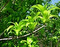
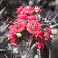
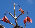
Media in category "Mount Yoloko"
The following 36 files are in this category, out of 36 total.
-
 Aloe mawii - Mount Yoloko (10003417126).jpg 2,007 × 1,683; 1.05 MB
-
 Aloe mawii - Mt. Yoloko landscape (10003417096).jpg 2,467 × 1,830; 1.03 MB
-
 Aloe mawii - summit of Mt Yokolo (10021663794).jpg 2,332 × 1,312; 1.13 MB
-
 Anchomanes abbreviata - inflorescence (5380771490).jpg 1,496 × 2,001; 571 KB
-
 Black Tacca - flower detail (5329430141).jpg 875 × 915; 236 KB
-
 Black Tacca - fruits (5623900872).jpg 800 × 700; 591 KB
-
 Black Tacca - leaves (5623851756).jpg 800 × 600; 776 KB
-
 Black Tacca inbetween hybrid plants (5623778032).jpg 800 × 600; 696 KB
-
 Capparidaceae - scape (10003416636).jpg 2,155 × 2,081; 1.04 MB
-
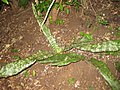
 Climbing fern - Mt. Yokolo (10021664394).jpg 4,008 × 2,284; 944 KB
-
 Deciduous forest with Hyphaene petersiana.jpg 1,024 × 768; 438 KB
-
 Dracaena reflexa (5380175889).jpg 800 × 620; 567 KB
-
 Dracaena reflexa - seeds (5356301943).jpg 757 × 800; 631 KB
-
 Euphorbia - Monte Yokola (5380176953).jpg 858 × 856; 200 KB
-
 Euphorbia sp. dwarf 1 - Mt Yokolo (10022727536).jpg 2,016 × 1,668; 1.07 MB
-
 Euphorbia sp. dwarf 2 - Mt Yokolo (10021665644).jpg 2,883 × 1,685; 1.17 MB
-
 Euphorbia sp. dwarf 3 - Mt Yokolo (10022728246).jpg 2,052 × 1,768; 1.24 MB
-
 Euphorbia sp.1 - Mt. Yoloko (10003629114).jpg 2,058 × 2,625; 1,006 KB
-
 Euphorbia sp.2 - Mt. Yoloko (10003629624).jpg 2,916 × 3,888; 1.12 MB
-
 Euphorbia sp.3 - Mt. Yoloko (10003630084).jpg 2,073 × 1,555; 1.14 MB
-
 Euphorbia sp.4 - Mt. Yoloko (10003630094).jpg 2,042 × 2,627; 1.02 MB
-
 Euphorbia sp.5 - Mt. Yoloko (10003630124).jpg 2,721 × 3,628; 1.12 MB
-
 Euphorbia sp.6 - Mt. Yokolo (10003715854).jpg 1,944 × 2,218; 1.2 MB
-
 Euphorbia sp.7 - Mt. Yokolo (10003630494).jpg 1,944 × 2,592; 1.3 MB
-
 Flowering bulbs - Mt Yokolo (10021663864).jpg 1,663 × 1,992; 1,001 KB
-
 Gladiolus decoratus 5 (11830731675).jpg 2,055 × 2,470; 2.19 MB
-
 Hildegardia migeodii - Mt. Yoloko (10022727476).jpg 2,672 × 2,166; 1.06 MB
-
 Hildegardia migeodii 2 - Mt. Yokolo (10022727206).jpg 2,492 × 2,522; 1.04 MB
-
 Hildegardia migeodii 3 - Mt Yokolo (10022727516).jpg 1,006 × 1,042; 888 KB
-
 Landscape with Aloe mawii (6132137555).jpg 1,024 × 768; 427 KB
-
 Monte Yokola (5380779860).jpg 800 × 600; 631 KB
-
 Orchid - Mount Yoloko (10003416676).jpg 1,204 × 1,184; 499 KB
-
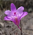 Orchid - Mt. Yoloko (10003417046).jpg 1,413 × 1,469; 699 KB
-
 Sansevieria kirkii (?) - Mount Yokolo (5623903044).jpg 800 × 600; 697 KB
-
 Sansevieria kirkii - dry season survival (6612298933).jpg 1,123 × 1,300; 767 KB
-
 View from the summit of Mt Yokolo (10021663854).jpg 2,592 × 1,944; 1.15 MB
.jpg)
.jpg)
.jpg)
.jpg)
.jpg)
.jpg)
.jpg)
.jpg)
.jpg)
.jpg)

.jpg)
.jpg)
.jpg)
.jpg)
.jpg)
.jpg)
.jpg)
.jpg)
.jpg)
.jpg)
.jpg)
.jpg)
.jpg)
.jpg)
.jpg)
.jpg)
.jpg)
.jpg)
.jpg)
.jpg)
.jpg)
_-_Mount_Yokolo_(5623903044).jpg)
.jpg)
.jpg)