Category:Mountains with snow in Uttarakhand
Media in category "Mountains with snow in Uttarakhand"
The following 200 files are in this category, out of 346 total.
(previous page) (next page)-
 "Didihat Town and Panchachuli peaks in the background.jpg".jpg 2,048 × 1,536; 585 KB
-
 (A) view of Himalayan foothills, Uttarakhand India November 2013.jpg 3,266 × 2,258; 2.9 MB
-
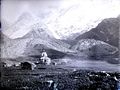
 1882 Photograph of Kedarnath.jpg 635 × 477; 190 KB
-
 A helicopter taking pilgrims to kedarnath.jpg 4,608 × 2,592; 3.56 MB
-
 A view of Neelkanth mountain.jpg 2,448 × 3,264; 2.37 MB
-
 Another valley, this one is better.jpg 4,096 × 2,304; 3.42 MB
-
 Auli mountains.jpg 5,184 × 3,456; 2.02 MB
-
 Badrinath hills.jpg 4,160 × 3,120; 4.34 MB
-
 Badrinath landscape.JPG 3,456 × 2,304; 2.58 MB
-
 Badrinath mountains.jpg 5,184 × 3,456; 6.57 MB
-
 Badrinath Sight.jpg 3,264 × 1,836; 2.78 MB
-
 Badrinath, Uttarakhand 246422, India - panoramio (2).jpg 1,600 × 1,067; 322 KB
-
 Badrinath1.jpg 4,320 × 2,432; 2.99 MB
-
 Bageshwar Town.jpg 6,000 × 4,000; 5.14 MB
-
 Bageshwar, Uttarakhand, India - panoramio.jpg 1,600 × 761; 334 KB
-
 Barkot With Bandarpunch.jpg 1,600 × 1,200; 412 KB
-
 Basecamp Kedarnath Uttarakhand.jpg 1,920 × 1,080; 262 KB
-
 Beautiful Himalyan ranges , badrinath india.jpg 4,032 × 3,024; 1.87 MB
-
 Beautiful Kedarnath2.jpg 992 × 744; 100 KB
-
 Beautiful secne of Montains near Badrinath.jpg 744 × 992; 29 KB
-
 Bethartoli peak from Thaing villgae.jpg 4,608 × 2,592; 3.74 MB
-
 Bhadrinath Temple and Nar Narayan.JPG 2,816 × 2,112; 1.04 MB
-
 Bhagat Kharak, Garhwal, India, 1934.jpg 520 × 327; 32 KB
-
 Bhagirathi River at Gangotri WTK20150915-IMG 2703.jpg 4,608 × 3,456; 2.04 MB
-
 Bhagirathi River at Gangotri.JPG 2,304 × 1,728; 1.93 MB
-
 Bharmatal trek camp site.jpg 2,112 × 2,112; 564 KB
-
 Binsar, a view of Kumaon Himalayas.jpg 1,024 × 702; 317 KB
-
 Blkn.JPG 1,600 × 1,143; 276 KB
-
 Borassu pass.jpg 4,288 × 2,848; 5.89 MB
-
 Brahmatal camp site.jpg 5,184 × 3,456; 4.06 MB
-
 Brahmatal.jpg 6,000 × 3,664; 4.86 MB
-
 Camels Back Mountain View (5281792060).jpg 4,000 × 3,000; 2.19 MB
-
 Chandrashila peak Uttarakhand.jpg 1,920 × 1,080; 255 KB
-
 Charming Himalyan ranges , badrinath india.jpg 4,032 × 3,024; 1.3 MB
-
 Chaukhambha (3641812744).jpg 3,872 × 2,592; 4.84 MB
-
 Chaukori.jpg 4,407 × 800; 796 KB
-
 Chm.JPG 1,600 × 1,143; 307 KB
-
 Click Direct from The Badrinath Temple.jpg 4,608 × 3,456; 2.42 MB
-
 Click Directly from The Badrinath Temple.jpg 4,608 × 3,456; 2.52 MB
-
 Closeup view of Kalanag,Dhumdhar kandi pass 1991 - panoramio.jpg 1,002 × 1,483; 1.57 MB
-
 Der Szurdse Kund aus Süden mit der Moräne des Milam-Gletschers.jpg 2,443 × 1,756; 1.57 MB
-
 Devi Kund, Uttarakhand.jpg 6,000 × 4,000; 12.69 MB
-
 Dhara vilage.jpg 4,608 × 3,456; 5.1 MB
-
 Distant Snows (5283894775).jpg 3,213 × 2,224; 1,018 KB
-
 Distant Snows (5284491590).jpg 3,648 × 2,529; 1.53 MB
-
 Dkd 2.jpg 4,032 × 3,024; 1.92 MB
-
 Dkd peak.jpg 4,032 × 3,024; 4.04 MB
-
 DraupadiKaDanda-HimalayanPeak-Garhwal,India.jpg 1,148 × 788; 134 KB
-
 F-2, Uttarakhand, India - panoramio.jpg 4,000 × 3,000; 476 KB
-
 FILE615.jpg 4,320 × 2,432; 2.72 MB
-
 Fire and Ice - panoramio.jpg 3,648 × 2,736; 2.38 MB
-
 Fully covered snow hill view just behind kedarnath 06.jpg 780 × 1,040; 78 KB
-
 Fully covered snow hill view just behind kedarnath 07.jpg 2,160 × 2,160; 1.5 MB
-
 Gangotri (ganga river).jpg 6,000 × 4,000; 5.01 MB
-
 Gangotri - Debabrata Ghosh, Birati.jpg 1,152 × 814; 340 KB
-
 Gangotri 15.JPG 2,048 × 1,536; 1.22 MB
-
 Gangotri 16.JPG 2,048 × 1,536; 937 KB
-
 Gangotri 17.JPG 2,048 × 1,536; 889 KB
-
 Gangotri 18.JPG 2,048 × 1,536; 852 KB
-
 Gangotri 19.JPG 2,048 × 1,536; 1.3 MB
-
 Gangotri 20.JPG 2,048 × 1,536; 988 KB
-
 Gangotri at night - Debabrata Ghosh, Birati.jpg 1,357 × 972; 201 KB
-
 Gangotri beauty.jpg 780 × 1,040; 127 KB
-
 Gangotri group of mountains.jpg 4,608 × 1,797; 3.35 MB
-
 Gangotri in evening - Debabrata Ghosh, Birati.jpg 1,350 × 807; 331 KB
-
 GANGOTRI MORNING- photography by Debabrata Ghosh, Birati.jpg 800 × 600; 124 KB
-
 Gangotri, Ganga riverbed.jpg 918 × 1,632; 421 KB
-
 Gangotri.JPG 2,048 × 1,536; 1.42 MB
-
 GangotriGroup.jpg 2,451 × 710; 230 KB
-
 Garhwal Himalaya views from Rudrpryag to Ukhimath during a road journey in winter 02.jpg 3,644 × 2,051; 1.19 MB
-
 Garhwal Himalaya views from Rudrpryag to Ukhimath during a road journey in winter 03.jpg 2,823 × 1,833; 1.69 MB
-
 Garhwal Himalaya views from Rudrpryag to Ukhimath during a road journey in winter 04.jpg 3,633 × 2,161; 2.05 MB
-
 Garhwal Himalaya views from Rudrpryag to Ukhimath during a road journey in winter 05.jpg 3,648 × 2,736; 2.6 MB
-
 Garhwal Himalaya views from Rudrpryag to Ukhimath during a road journey in winter 06.jpg 3,020 × 2,036; 1.29 MB
-
 Garhwal Himalaya views from Rudrpryag to Ukhimath during a road journey in winter 07.jpg 2,684 × 1,698; 1.39 MB
-
 Garhwal Himalaya views from Rudrpryag to Ukhimath during a road journey in winter 08.jpg 3,412 × 2,189; 1.53 MB
-
 Garhwal Himalaya views from Rudrpryag to Ukhimath during a road journey in winter 09.jpg 3,476 × 2,033; 1.28 MB
-
 Garhwal Himalaya views from Rudrpryag to Ukhimath during a road journey in winter 10.jpg 3,002 × 1,989; 1.18 MB
-
 Garhwal Himalaya views from Rudrpryag to Ukhimath during a road journey in winter 11.jpg 2,995 × 1,495; 694 KB
-
 Garhwal Himalaya views from Rudrpryag to Ukhimath during a road journey in winter 12.jpg 3,001 × 1,992; 1.36 MB
-
 Garhwal Himalaya views from Rudrpryag to Ukhimath during a road journey in winter 13.jpg 2,717 × 1,747; 1,000 KB
-
 Garhwal Himalaya views from Rudrpryag to Ukhimath during a road journey in winter 14.jpg 2,965 × 1,668; 949 KB
-
 Garhwal Himalaya views from Rudrpryag to Ukhimath during a road journey in winter 15.jpg 3,230 × 1,885; 1.02 MB
-
 Garhwal Himalaya views from Rudrpryag to Ukhimath during a road journey in winter 16.jpg 3,390 × 1,890; 1.11 MB
-
 Garhwal Himalayan Ranges (5283898625).jpg 2,884 × 2,006; 842 KB
-
 Garhwal Himalayas cloud and snow.jpg 4,000 × 3,000; 2.57 MB
-
 Garhwal Himalayas covered in snow.jpg 4,000 × 3,000; 2.15 MB
-
 Garhwal Himalayas only snow.jpg 4,000 × 3,000; 2.08 MB
-
 Garhwal Himalayas sharp mountain peek.jpg 4,000 × 3,000; 1.91 MB
-
 Garhwal Himalayas sharp peek.jpg 4,000 × 3,000; 2.07 MB
-
 Garhwal Himalayas snow covered.jpg 4,000 × 3,000; 2.11 MB
-
 Garhwal Himalayas snow layer.jpg 4,000 × 3,000; 2.7 MB
-
 Garhwal Himalayas snow.jpg 4,000 × 3,000; 2.47 MB
-
 Garhwal Himalayas view.jpg 4,000 × 3,000; 2.14 MB
-
 Garhwal Himalayas.jpg 4,000 × 3,000; 2.39 MB
-
 Garhwal Range 01.jpg 3,968 × 2,976; 2.61 MB
-
 Garhwal Range 04.jpg 3,968 × 2,976; 2.55 MB
-
 Garhwal Range 08.jpg 3,968 × 2,976; 2.67 MB
-
 Garhwal Range.jpg 3,968 × 2,976; 2.56 MB
-
 Garrhwal Himal (5281184955).jpg 4,000 × 3,000; 2.15 MB
-
 Garrhwal Himal (5281186145).jpg 3,612 × 2,500; 1.59 MB
-
 Gau mukh (47).JPG 2,048 × 1,536; 1.02 MB
-
 Gg 18.JPG 2,048 × 1,536; 803 KB
-
 Gg 19.JPG 2,048 × 1,536; 877 KB
-
 Gg 23.JPG 2,048 × 1,536; 955 KB
-
 Gg 24.JPG 2,048 × 1,536; 993 KB
-
 Gg 25.JPG 2,048 × 1,536; 750 KB
-
 Gg 26.JPG 2,048 × 1,536; 758 KB
-
 Gg 38.JPG 2,048 × 1,536; 663 KB
-
 Gg 39.JPG 2,048 × 1,536; 720 KB
-
 Gg 40.JPG 2,048 × 1,536; 727 KB
-
 Gg 41.JPG 2,048 × 1,536; 788 KB
-
 Gg 42.JPG 2,048 × 1,536; 731 KB
-
 Gg 43.JPG 2,048 × 1,536; 748 KB
-
 Glacial melt water carving the ice, river source Himalayas India.jpg 6,000 × 4,000; 2.94 MB
-
 Glacier reminents.jpg 3,072 × 1,728; 1.23 MB
-
 Glimses of Himalayas.jpg 2,560 × 1,920; 2.22 MB
-
 Haathi parvat.jpg 2,285 × 1,714; 2.39 MB
-
 Har Ki Dun 1.jpg 3,456 × 5,184; 6.2 MB
-
 Har Ki Dun 2.jpg 3,456 × 5,184; 6.41 MB
-
 Har Ki Dun 3.jpg 5,184 × 3,456; 5.55 MB
-
 Har Ki Dun 4.jpg 5,184 × 3,456; 4.59 MB
-
 Har Ki Dun 5.jpg 5,184 × 3,456; 4.56 MB
-
 Har Ki Dun 6.jpg 5,184 × 3,456; 4.44 MB
-
 Harshit 2 image.jpg 4,032 × 3,024; 1.15 MB
-
 Harshit's 4 image.jpg 4,032 × 3,024; 2.92 MB
-
 Hiking in Uttarakhand India November 2013.jpg 4,000 × 2,672; 3.64 MB
-
 Himalaya mountain range with peaks covered in snow during summers.jpg 4,608 × 2,592; 1.8 MB
-
 Himalaya mountain range with peaks covered in snow.jpg 4,608 × 2,592; 1.94 MB
-
 Himalaya Panorama Alok Prasad.jpg 9,704 × 904; 1.22 MB
-
 Himalaya view from Barkot city.jpg 1,600 × 1,200; 1.36 MB
-
 Himalayan peak Kedarnath ,Chaukhamaba and others from Deoria Tal.jpg 1,800 × 578; 132 KB
-
 Himalayan View (5275300549).jpg 3,565 × 2,464; 1.34 MB
-
 Himalayan View (5275302861).jpg 3,694 × 2,565; 1.4 MB
-
 Himalayan View (5275303457).jpg 3,448 × 2,394; 1.29 MB
-
 Himalayan View (5275878272).jpg 4,000 × 3,000; 1.88 MB
-
 Himalayan View (5275880902).jpg 4,000 × 3,000; 1.46 MB
-
 Himalayan view from Chandrashila.JPG 4,000 × 3,000; 5.53 MB
-
 Himalayan view from Kosani.jpg 4,160 × 3,120; 1.9 MB
-
 Himalayan View from Landour (5275877276).jpg 3,540 × 2,450; 1.42 MB
-
 Himalayan View.jpg 1,622 × 1,080; 233 KB
-
 Himalayas at dusk from Mussoorie, Uttarakhand.jpg 2,688 × 1,028; 577 KB
-
 Himalayas from Kedarkantha Summit.jpg 4,160 × 2,340; 3.5 MB
-
 Himalayas in Auli.jpg 2,592 × 1,944; 1.31 MB
-
 Himalayas in the morning light.jpg 1,500 × 465; 167 KB
-
 Himalayas near Auli.jpg 3,456 × 2,304; 1.65 MB
-
 Himalayas near Ukhimath, Rudraprayag.jpg 3,264 × 2,448; 1.75 MB
-
 HimalayaSnow@Badrinath.jpg 4,496 × 3,000; 7.25 MB
-
 Himalyan ranges , badrinath india.jpg 4,032 × 3,024; 1.99 MB
-
 Jogin I.jpg 2,844 × 1,932; 4.44 MB
-
 Joshimath peak(behind the scenes of Anjaan ek dastak).jpg 1,920 × 1,440; 2.19 MB
-
 Joshimath Snow.jpg 1,080 × 735; 161 KB
-
 Joshimath.jpg 3,264 × 2,448; 1.72 MB
-
 Joshimath2356.jpg 3,264 × 2,448; 1.16 MB
-
 Juda Ka Tabal.jpg 5,523 × 3,682; 5.63 MB
-
 Kala Parvat.jpg 3,264 × 1,836; 2.55 MB
-

-

-
 Kamet peak, Uttarakhand.jpg 4,000 × 3,000; 4.26 MB
-
 Kedar from Tungnath vvnataraj.jpg 3,008 × 2,000; 2.27 MB
-
 Kedar nath hills in snow and clouds.jpg 1,280 × 590; 68 KB
-
 Kedar peak.jpg 4,000 × 3,000; 3.38 MB
-
 Kedar Valley.jpg 4,208 × 2,368; 2.54 MB
-
 Kedarnath (2 of 1).jpg 4,000 × 4,000; 11.16 MB
-
 Kedarnath 002.jpg 3,264 × 1,836; 1.49 MB
-
 Kedarnath 003.jpg 3,264 × 1,836; 2.16 MB
-
 Kedarnath 004.jpg 1,836 × 3,264; 1.77 MB
-
 Kedarnath 005.jpg 3,264 × 1,836; 1.85 MB
-
 Kedarnath 010.jpg 1,836 × 3,264; 1.99 MB
-
 Kedarnath and Kedar Dome, Uttarakhand India November 2013.jpg 3,859 × 2,672; 3.48 MB
-
 Kedarnath basecamp.jpg 4,032 × 3,024; 2.6 MB
-
 Kedarnath Camp.jpg 960 × 1,280; 122 KB
-
 Kedarnath from Chopta (43705153930).jpg 2,048 × 1,441; 765 KB
-
 Kedarnath from Chopta (43705179960).jpg 2,048 × 644; 289 KB
-
 Kedarnath from Duggalbitta (43704655270).jpg 2,048 × 1,284; 989 KB
-
 Kedarnath Himalaya.jpg 2,176 × 4,608; 1.79 MB
-
 Kedarnath in 1860.jpg 600 × 450; 60 KB
-
 Kedarnath morning Sunrise.jpg 4,496 × 3,000; 7.39 MB
-
 Kedarnath peaks and temple.jpg 540 × 405; 62 KB
-
 Kedarnath shrine.jpg 3,264 × 2,448; 2.54 MB
-
 Kedarnath Temple and himalayas.jpg 4,608 × 3,456; 4.7 MB
-
 Kedarnath Temple in 2014.jpg 3,264 × 2,448; 3.38 MB
-
 Kedarnath temple in uttarakhand.jpg 4,000 × 1,800; 1.95 MB
-
 Kedarnath Temple with Snow Covered Mountains in Background.jpg 1,008 × 673; 328 KB
-
 Kedarnath Temple3.jpg 748 × 1,125; 126 KB
-
 Kedarnath view .jpg 4,096 × 2,304; 1.49 MB
-
 Kedarnath walkover.jpg 4,608 × 2,592; 2.77 MB
-
 Kedarnath, Bharte khunta and Thalay Sagar at dusk from Kartik Swamy.jpg 4,959 × 2,304; 1.43 MB
-
 Kedarnath.jpg 3,888 × 2,592; 3.84 MB
-
 Kedarnathhills.jpg 2,250 × 4,000; 2.32 MB
-
 Kedarnathji-mandir.JPG 2,304 × 1,728; 1.92 MB
-
 KedarRange.jpg 3,872 × 2,592; 7.55 MB
-
 Kuanri Pass, Uttarakhand, 4300m.jpg 6,000 × 4,000; 13.21 MB
-
 KUCHELA DHURA.JPG 1,529 × 1,211; 836 KB
-
 Lake of Kedarnath.jpg 2,992 × 2,000; 582 KB
-
 Lansdownesnow2.JPG 3,456 × 4,608; 5.56 MB
-
 Lincholi area Uttarakhand.jpg 1,920 × 1,080; 227 KB
-
 Lohaghat, Uttarakhand, India Himalayan Range November 2013.jpg 12,621 × 3,894; 20.23 MB
-
 Maiktoli Mrigthuni Devtoli.jpg 5,184 × 3,456; 4.07 MB
-
 Maiktoli.jpg 4,736 × 3,088; 9.99 MB

_view_of_Himalayan_foothills,_Uttarakhand_India_November_2013.jpg)


.jpg)


.jpg)


.jpg)


.jpg)
.jpg)


.jpg)


.jpg)


.jpg)
.jpg)
.JPG)


.jpg)
.jpg)
.jpg)
.jpg)
.jpg)


.jpg)


,_Uttarkashi_district,_Garhwal_division,_Uttarakhand,_India_a5-IMG_0514.jpg)
,_Uttarkashi_district,_Garhwal_division,_Uttarakhand,_India_a5-IMG_0515.jpg)


.jpg)


.jpg)
.jpg)


.jpg)
.jpg)