Category:Mr Andreaestraat 2A, Kollum
| Object location | | View all coordinates using: OpenStreetMap |
|---|
 | |||||
| Upload media | |||||
| Instance of | |||||
|---|---|---|---|---|---|
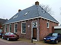
| Location | Kollum, Noardeast-Fryslân, Friesland, Netherlands | ||||
| Located on street |
| ||||
| Heritage designation |
| ||||
 | |||||
|
This is a category about rijksmonument number 23723
|
| Address |
|
Subcategories
This category has only the following subcategory.
S
Media in category "Mr Andreaestraat 2A, Kollum"
The following 8 files are in this category, out of 8 total.
-
 Gevel - Kollum - 20126610 - RCE.jpg 1,200 × 805; 174 KB
-
 Gevelsteen Voormalige lagereschool, Mr. Andreaestraat 2-3a, Kollum.JPG 3,896 × 2,924; 2.26 MB
-
 Kollum - voormalige lagere school - gevelsteen.jpg 3,520 × 2,640; 3.04 MB
-
 Kollum - voormalige lagere school.jpg 3,225 × 2,419; 3 MB
-
 Overzicht - Kollum - 20126607 - RCE.jpg 1,200 × 1,200; 262 KB
-
 Voor- en linker zijgevel - Kollum - 20126609 - RCE.jpg 1,198 × 1,200; 308 KB
-
 Voorgevel - Kollum - 20126608 - RCE.jpg 1,179 × 1,200; 273 KB
-
 Voormalige lagereschool, Mr. Andreaestraat 2-2a, Kollum.JPG 4,608 × 3,456; 3.31 MB


