Category:Mt. Zion Covered Bridge
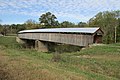
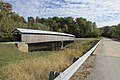
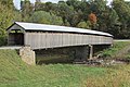
Mt. Zion Covered Bridge or Beech Fork Creek Covered Bridge, 458 Mt Zion Rd, Springfield, KY
| Object location | | View all coordinates using: OpenStreetMap |
|---|
bridge in Washington County, United States of America   | |||||
| Upload media | |||||
| Instance of | |||||
|---|---|---|---|---|---|
| Location | Washington County, Kentucky | ||||
| Crosses |
| ||||
| Heritage designation |
| ||||
| Inception |
| ||||
| Dissolved, abolished or demolished date |
| ||||
 | |||||
Media in category "Mt. Zion Covered Bridge"
The following 24 files are in this category, out of 24 total.
-
 Burr Arch 19-10-19 823.jpg 4,608 × 3,072; 3.47 MB
-
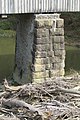
 Ctr Pier 19-10-19 826.jpg 4,608 × 3,072; 2.98 MB
-
 Ctr Pier 19-10-19 833.jpg 3,072 × 4,608; 4.78 MB
-
 Ctr pier 19-10-19 835.jpg 3,072 × 4,608; 4.38 MB
-
 Ctr pier 19-10-19 837.jpg 3,072 × 4,608; 4.94 MB
-
 East Portal 19-10-19 830.jpg 4,608 × 3,072; 3.86 MB
-
 Ford 19-10-19 841.jpg 3,072 × 4,608; 6.61 MB
-
 Joint 19-10-19 824.jpg 3,072 × 4,608; 3.29 MB
-
 Joint 19-10-19 828.jpg 4,608 × 3,072; 3.13 MB
-
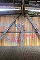 KingsPost 19-10-19 827.jpg 3,072 × 4,608; 3.17 MB
-
 MOUNT ZION COVERED BRIDGE, WASHINGTON COUNTY,KY.jpg 720 × 540; 92 KB
-
 Mt Zion Bridge 831.jpg 4,608 × 3,072; 4.03 MB
-
 Mt Zion Bridge 832.jpg 4,608 × 3,072; 4.24 MB
-
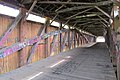
 Mt Zion CB 19-10-19 820.jpg 4,608 × 3,072; 4.47 MB
-
 Mt Zion CB 19-10-19 836.jpg 4,608 × 3,072; 4.52 MB
-
 Mt Zion CB 19-10-19 838.jpg 4,608 × 3,072; 4.3 MB
-
 Mt Zion CB 19-10-19 839.jpg 4,608 × 3,072; 4.77 MB
-
 Mt Zion CB 19-10-19 840.jpg 3,072 × 4,608; 5.25 MB
-
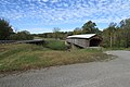
 New Bridge 19-10-19 821.jpg 4,608 × 3,072; 4.53 MB
-
 Portal frame 19-10-19 829.jpg 3,072 × 4,608; 4.75 MB
-
 Queenposts 19-10-19 825.jpg 4,608 × 3,072; 3.27 MB
-
 REC21 (3198b).jpg 2,386 × 1,757; 1.01 MB
-
 West abutment 19-10-19 834.jpg 3,072 × 4,608; 4.82 MB
-
 West Portal 19-10-19 822.jpg 4,608 × 3,072; 4.48 MB


.jpg)

