Category:Muddy Fork Cowlitz River Bridge
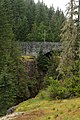
English: Muddy Fork Cowlitz River Bridge (Box Canyon Bridge), spanning Muddy Fork Cowlitz River on Stevens Canyon Highway in Mount Rainier National Park. Historic American Engineering Record (HAER): WA-60.
| Object location | | View all coordinates using: OpenStreetMap |
|---|
Subcategories
This category has only the following subcategory.
Media in category "Muddy Fork Cowlitz River Bridge"
The following 4 files are in this category, out of 4 total.
-
 Mount-Rainier-Park-Canyon-Bridge-6994.jpg 2,816 × 2,112; 1.47 MB
-
 MRNP — Muddy Fork Cowlitz River Bridge.jpg 1,500 × 1,000; 1.99 MB
-
 Muddy Fork Cowlitz River Bridge (58282165-00ec-4f75-9765-fed3fb88454b).jpg 2,140 × 1,457; 910 KB
-
 PUENTE SOBRE LA GARGANTA - panoramio.jpg 2,848 × 4,288; 4.58 MB


.jpg)
