Category:Mule Mountains (Arizona)
English: The en:Mule Mountains of Cochise County, Arizona, (southeast Arizona, en:Madrean Sky Islands section). en:Bisbee, Arizona is located at the south mountain's foothills, & lower elevations.
mountain range in Arizona, United States  | |||||
| Upload media | |||||
| Instance of | |||||
|---|---|---|---|---|---|
| Location | Arizona | ||||
| Width |
| ||||
| Area |
| ||||
| Elevation above sea level |
| ||||
 | |||||
Subcategories
This category has the following 2 subcategories, out of 2 total.
B
C
- Chihuahua Hill (5 F)
Media in category "Mule Mountains (Arizona)"
The following 17 files are in this category, out of 17 total.
-
 AZ 80 South Tombstone.jpg 2,856 × 1,904; 1.65 MB
-
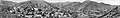 Bisbee 1916.jpg 19,169 × 2,901; 33.88 MB
-
 Bisbee AZ Banner.jpg 2,100 × 300; 605 KB
-
 Bisbee, Arizona, c. 1879.tif 709 × 565; 517 KB
-
 Camping East side of Mule Range (4483088798).jpg 3,648 × 2,736; 2.45 MB
-
 Morning over the Mules (47161931272).jpg 5,184 × 3,456; 762 KB
-
 Morning over the Mules (47213918731).jpg 5,184 × 3,456; 798 KB
-
 Morning view from our camp - East side of Mule Range (4483088436).jpg 3,648 × 2,736; 3.13 MB
-
 Mule Mountains (31593033307).jpg 4,608 × 2,811; 3.01 MB
-
 Mule Mountains and the San Pedro Valley (46481285632).jpg 4,608 × 1,974; 540 KB
-
 Mule Mountains, AZ.jpg 1,600 × 1,063; 1.14 MB
-
 Mule Mountains.jpg 1,000 × 664; 799 KB
-
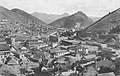 PostcardBisbeeAZArialLookingEastCirca1909.jpg 675 × 426; 244 KB
-
 USGS Map of Santa Rita and Patagonia Mts 1910.jpg 928 × 588; 280 KB
-

-
 Youngblood Hill Shrine.jpg 1,024 × 680; 671 KB
-
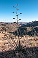 Yucca in the Mule Mountains.jpg 664 × 1,000; 798 KB

.jpg)
.jpg)
.jpg)
.jpg)
.jpg)
.jpg)


_early_morning,_cochise_co,_az_-07_(50610212226).jpg)

