Category:Multilingual SVG maps
Media in category "Multilingual SVG maps"
The following 24 files are in this category, out of 24 total.
-
 100 Years War France 1435.svg 948 × 945; 141 KB
-
 2020 Nagorno-Karabakh war.svg 512 × 405; 179 KB
-
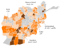 Afghanistan insurgency 2017.svg 1,026 × 778; 799 KB
-
 Anaximander world map-en.svg 1,063 × 1,063; 21 KB
-
 Antarctica.svg 512 × 511; 655 KB
-
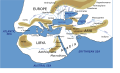
 Course Channeltunnel en.svg 472 × 387; 43 KB
-
 Deportation of Jews by Assyrians.svg 600 × 423; 126 KB
-
 First map of the world according to Anaximander (6th century BC).svg 512 × 431; 70 KB
-
 Herodotus world map-en.svg 788 × 476; 319 KB
-
 Kantone der Schweiz.svg 1,000 × 700; 2.86 MB
-
 Korea DMZ.svg 800 × 600; 60 KB
-
 Les Micmacs (multilingual).svg 3,387 × 2,113; 455 KB
-
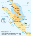 Malacca Sultanate en.svg 512 × 581; 373 KB
-
 Map Europe 1923-fr.svg 1,037 × 704; 228 KB
-
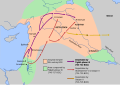
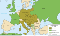 Map Europe alliances 1914-en.svg 1,002 × 593; 97 KB
-
 Map of the national days by country.svg 863 × 443; 1.53 MB
-
 Map of USA with state names ar.svg 959 × 593; 344 KB
-
 Map Thirteen Colonies 1775.svg 914 × 628; 325 KB
-
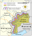 Minsk Protocol.svg 480 × 527; 168 KB
-
 Peninsule acadienne (multilingue).svg 1,180 × 825; 1.21 MB
-
 Political map of Canada.svg 1,130 × 920; 272 KB
-
 Turkey-faults-platenames.svg 555 × 379; 174 KB
-
 Writing directions of the world ru.svg 1,684 × 1,055; 436 KB
-
 Writing directions of the world.svg 1,684 × 1,055; 307 KB


.svg)


.svg)


.svg)


