Category:Mungret Abbey, Limerick
| Object location | | View all coordinates using: OpenStreetMap |
|---|

|
This object is indexed in the Archaeological Survey of Ireland under SMR No. LI013-009005-
Geographic information system of the National Monuments Service: Historic Environment Viewer – Database record. |
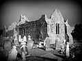
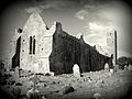
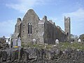
English: Probably, it is an ancient parish church. In the 13th century, there was no abbey recorded, there.
Media in category "Mungret Abbey, Limerick"
The following 7 files are in this category, out of 7 total.
-
 Abbey Church, Mungret, Limerick.png 1,402 × 852; 1.12 MB
-
 Mungret Abbey - geograph.org.uk - 498710.jpg 640 × 480; 77 KB
-
 Mungret abbey 2.jpg 2,816 × 2,112; 1.47 MB
-
 Mungret Abbey part of the Mungret Churches.jpg 4,752 × 3,168; 2.55 MB
-
 Mungret Abbey.jpg 2,816 × 2,112; 1.28 MB
-
 MungretAbbey.jpg 4,224 × 3,168; 4.42 MB
-
 Old Mungret Church.jpg 4,034 × 2,590; 9.06 MB


