Category:Municipal Park (Luxembourg City)
| Object location | | View all coordinates using: OpenStreetMap |
|---|
park in Luxembourg  D'Kinnekswiss am Stater Park | |||||
| Upload media | |||||
| Instance of | |||||
|---|---|---|---|---|---|
| Named after |
| ||||
| Location | Luxembourg, Canton of Luxembourg, Luxembourg | ||||
| Architect | |||||
| Operator | |||||
| Inception |
| ||||
| Area |
| ||||
 | |||||
Subcategories
This category has the following 7 subcategories, out of 7 total.
Media in category "Municipal Park (Luxembourg City)"
The following 29 files are in this category, out of 29 total.
-
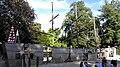
 2022-05-28 Luxembourg Night Marathon (129).jpg 4,032 × 2,268; 3.37 MB
-
 Buste vum Mahatma Gandhi am Stadpark zu Lëtzebuerg.jpg 2,268 × 4,032; 4.14 MB
-
 Luksemburgo (2015) 141.jpg 4,160 × 2,336; 4.11 MB
-
 Luksemburgo (2015) 142.jpg 4,160 × 2,336; 4.47 MB
-
 Luksemburgo (2015) 143.jpg 4,160 × 2,336; 4.51 MB
-
 Luksemburgo (2015) 144.jpg 4,160 × 2,336; 4.2 MB
-
 Luxembourg, Fontaine d'eau publique (1).jpg 3,264 × 2,448; 4.34 MB
-
 Luxembourg, Fontaine d'eau publique (2).jpg 3,264 × 2,448; 3.76 MB
-
 Luxembourg, Fontaine Xavier Brasseur (projet).png 337 × 460; 155 KB
-
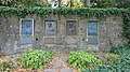
 Luxembourg, Plaques commémoratives des cyclistes luxembourgeois (101).jpg 3,198 × 2,390; 3.81 MB
-
 Memortabulo pri Charly Gaul en la Municipa parko de Luksemburgo.jpg 2,336 × 4,160; 3.7 MB
-
 Memortabulo pri Elsy Jacobs en la Municipa parko de Luksemburgo.jpg 2,336 × 4,160; 4.08 MB
-
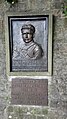 Memortabulo pri François Faber en la Municipa parko de Luksemburgo.jpg 2,336 × 4,160; 4.12 MB
-
 Memortabulo pri Nicolas Frantz en la Municipa parko de Luksemburgo.jpg 2,336 × 4,160; 4.31 MB
-
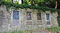 Memortabuloj en la Municipa parko de Luksemburgo.jpg 4,160 × 2,336; 4.26 MB
-
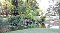
 Municipa parko en Luksemburgo 01.jpg 4,160 × 2,336; 4.59 MB
-
 Municipa parko en Luksemburgo 02.jpg 4,160 × 2,336; 4.46 MB
-
 Municipa parko en Luksemburgo 03.jpg 2,336 × 4,160; 4.12 MB
-
 Municipa parko en Luksemburgo 04.jpg 4,160 × 2,336; 4.77 MB
-
 Municipa parko en Luksemburgo 05.jpg 4,160 × 2,336; 4.87 MB
-
 Municipa parko en Luksemburgo 06.jpg 4,160 × 2,336; 4.08 MB
-
 Municipa parko en Luksemburgo 07.jpg 4,160 × 2,336; 3.69 MB
-
 Municipa parko en Luksemburgo 08.jpg 2,336 × 4,160; 5.75 MB
-
 Municipa parko en Luksemburgo 09.jpg 2,336 × 4,160; 2.42 MB
-
 Municipa parko en Luksemburgo 12.jpg 4,160 × 2,336; 6.17 MB
-
 Municipa parko en Luksemburgo 13.jpg 2,336 × 4,160; 5.35 MB
-
 Municipa parko en Luksemburgo 14.jpg 4,160 × 2,336; 5.26 MB
-
 Municipa parko en Luksemburgo 15.jpg 4,160 × 2,336; 5.41 MB
-
 Plaque commémorative de François Faber.jpg 4,032 × 2,268; 3.66 MB
.jpg)

_141.jpg)
_142.jpg)
_143.jpg)
_144.jpg)
.jpg)
.jpg)
.png)
.jpg)


