Category:National Register of Historic Places in Matanuska-Susitna Borough, Alaska
Boroughs of Alaska: Aleutians East · Bristol Bay · Denali · Fairbanks North Star · Kenai Peninsula · Ketchikan Gateway · Kodiak Island · Lake and Peninsula · Matanuska-Susitna · North Slope · Northwest Arctic · Petersburg · Consolidated city-boroughs: Anchorage · Haines · Juneau · Sitka · Wrangell · Yakutat
Census areas of the Unorganized Borough: Aleutians West · Bethel · Chugach · Copper River · Dillingham · Hoonah-Angoon · Nome · Prince of Wales-Hyder · Southeast Fairbanks · Yukon-Koyukuk
Census areas of the Unorganized Borough: Aleutians West · Bethel · Chugach · Copper River · Dillingham · Hoonah-Angoon · Nome · Prince of Wales-Hyder · Southeast Fairbanks · Yukon-Koyukuk
Wikimedia list article | |||||
| Upload media | |||||
| Instance of | |||||
|---|---|---|---|---|---|
| Location |
| ||||
| |||||
Subcategories
This category has the following 9 subcategories, out of 9 total.
F
- Fairview Inn (7 F)
I
P
- Palmer Depot (3 F)
R
- Rebarchek Farm (6 F)
S
- Susitna River Bridge (7 F)
T
W
- Wasilla Depot (10 F)
- Wasilla Elementary School (5 F)
Media in category "National Register of Historic Places in Matanuska-Susitna Borough, Alaska"
The following 13 files are in this category, out of 13 total.
-
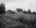 Bailey Colony Farm.jpg 951 × 746; 121 KB
-
 Hyland Hotel.jpg 1,920 × 2,560; 797 KB
-
 Independence Mine State Historical Park.JPG 4,288 × 2,848; 5.66 MB
-
 Knik Hall, Knik Site, "Vi Redington Hall" sign on side of building.jpg 3,072 × 2,304; 2.12 MB
-
 Knik Hall, Knik Site, Alaska.jpg 3,072 × 2,304; 2.12 MB
-
 Knik town site cabin.jpg 5,152 × 3,864; 4.17 MB
-
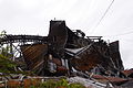 Remains of the Processing Mill with Rail Trestle.JPG 4,288 × 2,848; 4.78 MB
-
 Talkeetna Airstrip.jpg 2,560 × 1,920; 907 KB
-
 Teeland left.jpg 2,560 × 1,920; 880 KB
-
 Teeland plaques.jpg 1,920 × 2,560; 978 KB
-
 Teeland right.jpg 2,560 × 1,920; 952 KB
-
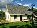 The Campbell House.JPG 3,263 × 2,448; 2.42 MB
-
 View of foot of Main Street, Wasilla, Alaska, early 1920s.jpg 1,603 × 1,032; 1.64 MB


