Category:Naturschutzgebiet Tote Täler
| Diese Kategorie repräsentiert ein Schutzgebiet nach Naturschutzrecht in Deutschland. |
|---|
| Diese Kategorie wurde nach einem klaren Schema angelegt, sie sollte nicht verschoben, gelöscht oder umkategorisiert werden. Sie ist unter anderem in dieser Uploadkarte hinterlegt. Beschreibung und Hintergründe auf der Seite des Wikiprojekts |
| Foto zu Wiki Loves Earth hochladen! - Seite von Wiki Loves Earth Deutschland |
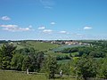
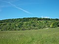
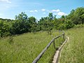
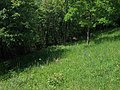
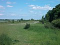
Deutsch: Naturschutzgebiet „Tote Täler“, NSG 128 in Balgstädt, Naumburg und Freyburg, Burgenlandkreis, Sachsen-Anhalt.
English: The Tote Täler ("Dead Valleys") are a nature reserve between the rivers Unstrut and Saale in Saxony-Anhalt, Germany.
nature reserve in Sachsen-Anhalt, Germany  | |||||
| Upload media | |||||
| Instance of | |||||
|---|---|---|---|---|---|
| Location | |||||
| Applies to jurisdiction | |||||
| IUCN protected areas category | |||||
| Inception |
| ||||
| Area |
| ||||
 | |||||
Media in category "Naturschutzgebiet Tote Täler"
The following 26 files are in this category, out of 26 total.
-
 0rchideen 12.jpg 3,633 × 2,650; 1.8 MB
-
 0rchideen 17.jpg 2,736 × 3,648; 6 MB
-
 0rchideen 18.jpg 3,648 × 2,736; 2.26 MB
-
 Größnitz-v-Orchideenweg.JPG 3,648 × 2,736; 2.48 MB
-
 Informationstafel.jpg 3,264 × 2,448; 2.81 MB
-
 KleinjenaHügel-TT.JPG 2,554 × 1,916; 1.49 MB
-
 KleinjenaWaldrand.JPG 3,648 × 2,736; 2.98 MB
-
 Knabenkraut (orchis purpurnes) in den Toten Tälern.jpg 3,024 × 4,032; 7.21 MB
-
 Konik-Fohlen.jpg 3,264 × 2,448; 1.44 MB
-
 Konik-Herde bei Sonnenuntergang.jpg 6,758 × 2,406; 4.78 MB
-
Orchideenexkursion.webm 1 min 6 s, 270 × 480; 541 KB
-
 Orchideenweg-TT1.JPG 3,648 × 2,736; 2.51 MB
-
 Orchideenweg-TT2.JPG 3,648 × 2,736; 2.48 MB
-
 Orchideenweg-TT3.JPG 3,648 × 2,736; 3.22 MB
-
 Orchideenweg-TT4.JPG 3,648 × 2,736; 2.36 MB
-
 Orchideenweg-TT5.JPG 3,648 × 2,736; 2.73 MB
-
 Orchis purpurea Wiese.jpg 1,200 × 900; 657 KB
-
 Rosa-Knabenkraut.jpg 2,448 × 3,264; 3.11 MB
-
 Rödel, Tote Täler Balgstädt 01.jpg 4,000 × 3,000; 4.55 MB
-
 Rödel, Tote Täler Balgstädt 02.jpg 3,000 × 4,000; 4.28 MB
-
 Rödel, Tote Täler Balgstädt 03.jpg 4,000 × 3,000; 4.43 MB
-
 Rödel-TT1.JPG 3,648 × 2,736; 2.51 MB
-
 Rödel-TT2.JPG 3,648 × 2,736; 1.86 MB
-
 Tote Täler, Informationstafel Rödel.jpg 4,000 × 3,000; 2.79 MB
-
 Wildpflanze 1.jpg 2,448 × 3,264; 3.32 MB
-
 Wildpflanze 2.jpg 2,448 × 3,264; 2.5 MB


_in_den_Toten_T%C3%A4lern.jpg)


