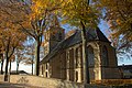
Category:Nederlands Hervormde Kerk, Buurmalsen
| Object location | | View all coordinates using: OpenStreetMap |
|---|
 | |||||
| Upload media | |||||
| Instance of |
| ||||
|---|---|---|---|---|---|
| Location | Geldermalsen, West Betuwe, Gelderland, Netherlands | ||||
| Street address |
| ||||
| Heritage designation |
| ||||
 | |||||
Kerk
|
This is a category about rijksmonument number 16492
|
Toren
|
This is a category about rijksmonument number 16493
|
| Address |
|
Subcategories
This category has the following 2 subcategories, out of 2 total.
Media in category "Nederlands Hervormde Kerk, Buurmalsen"
The following 73 files are in this category, out of 73 total.
-
 16492 Buurmalsen - Hervormde kerk.jpg 5,092 × 5,847; 29.26 MB
-
 BUURMALSEN HERVORMDE KERK 01.jpg 4,513 × 2,538; 3.38 MB
-
 BUURMALSEN HERVORMDE KERK 02.jpg 4,383 × 2,465; 2.53 MB
-
 BUURMALSEN NED.HERVORMDE KERK.jpg 3,261 × 4,348; 3.4 MB
-
 Buurmalsen NH Kerk 1.jpg 3,361 × 3,380; 6.24 MB
-
 Buurmalsen NH Kerk 2.jpg 4,022 × 3,386; 7.56 MB
-
 Buurmalsen. Hervormde kerk..jpg 4,770 × 3,177; 6.28 MB
-
 Buurmalsen. Muurschideringen. Hervormde kerk Buurmalsen..jpg 5,120 × 3,200; 6.69 MB
-
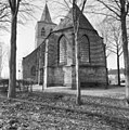
 En omgeving vanuit het zuid-westen - Buurmalsen - 20046134 - RCE.jpg 1,200 × 1,180; 390 KB
-
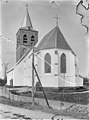
 Exterieur - Buurmalsen - 20046140 - RCE.jpg 961 × 1,200; 381 KB
-
 Exterieur NOORDGEVEL - Buurmalsen - 20273412 - RCE.jpg 960 × 1,200; 370 KB
-
 Exterieur OOSTGEVEL - Buurmalsen - 20273413 - RCE.jpg 1,042 × 1,200; 370 KB
-
 Exterieur vanuit het oosten - Buurmalsen - 20046138 - RCE.jpg 897 × 1,200; 197 KB
-
 Exterieur vanuit het oosten, Kerk - Buurmalsen - 20046136 - RCE.jpg 1,200 × 1,186; 418 KB
-
 Exterieur ZUIDGEVEL - Buurmalsen - 20273414 - RCE.jpg 1,043 × 1,200; 347 KB
-
 Exterieur ZUIDGEVEL, WESTGEVEL - Buurmalsen - 20273411 - RCE.jpg 1,037 × 1,200; 403 KB
-
 Gewelf koor - Buurmalsen - 20046166 - RCE.jpg 1,200 × 1,195; 306 KB
-
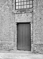 Ingang van de toren westzijde - Buurmalsen - 20046141 - RCE.jpg 884 × 1,200; 393 KB
-
 Interieur kap koor naar het noord-oosten - Buurmalsen - 20046186 - RCE.jpg 1,195 × 1,200; 399 KB
-
 Interieur kap koor naar het oosten - Buurmalsen - 20046185 - RCE.jpg 1,200 × 1,197; 351 KB
-
 Interieur kap koor, gezien naar het westen - Buurmalsen - 20046187 - RCE.jpg 1,185 × 1,200; 393 KB
-
 Interieur kap koor, naar het westen - Buurmalsen - 20046188 - RCE.jpg 1,192 × 1,200; 404 KB
-
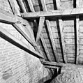 Interieur kap koor, noord-west hoek - Buurmalsen - 20046189 - RCE.jpg 1,195 × 1,200; 366 KB
-
 Interieur kap koor, zuid-west hoek - Buurmalsen - 20046190 - RCE.jpg 1,200 × 1,197; 387 KB
-
 Interieur kap koorsluiting - Buurmalsen - 20046191 - RCE.jpg 1,197 × 1,200; 366 KB
-
 Interieur zwam in kap koorsluiting - Buurmalsen - 20046192 - RCE.jpg 1,200 × 1,195; 432 KB
-
 INTERIEUR, - Buurmalsen - 20307006 - RCE.jpg 1,193 × 1,200; 333 KB
-
 INTERIEUR, - Buurmalsen - 20307008 - RCE.jpg 1,195 × 1,200; 345 KB
-
 INTERIEUR, - Buurmalsen - 20307010 - RCE.jpg 1,200 × 1,197; 307 KB
-
 INTERIEUR, - Buurmalsen - 20307011 - RCE.jpg 1,197 × 1,200; 371 KB
-
 INTERIEUR, - Buurmalsen - 20307012 - RCE.jpg 1,193 × 1,200; 399 KB
-
 Interieur, de koorvloer van bovenaf - Buurmalsen - 20271559 - RCE.jpg 1,200 × 1,200; 282 KB
-
 Interieur, deksel sarcophaag, toren - Buurmalsen - 20046184 - RCE.jpg 1,200 × 1,200; 312 KB
-
 INTERIEUR, DETAIL GEWELF - Buurmalsen - 20307003 - RCE.jpg 1,193 × 1,200; 351 KB
-
 INTERIEUR, DETAIL GEWELF - Buurmalsen - 20307004 - RCE.jpg 1,188 × 1,200; 285 KB
-
 INTERIEUR, DETAIL GEWELF - Buurmalsen - 20307005 - RCE.jpg 1,192 × 1,200; 339 KB
-
 Interieur, detail gewelfschildering - Buurmalsen - 20360066 - RCE.jpg 1,200 × 783; 184 KB
-
 Interieur, detail gewelfschildering - Buurmalsen - 20360067 - RCE.jpg 1,200 × 787; 179 KB
-
 Interieur, detail gewelfschildering - Buurmalsen - 20360068 - RCE.jpg 1,200 × 784; 211 KB
-
 Interieur, detail gewelfschildering - Buurmalsen - 20360069 - RCE.jpg 1,200 × 790; 185 KB
-
 INTERIEUR, DETAIL VAN KAPCONSTRUCTIE - Buurmalsen - 20307007 - RCE.jpg 1,190 × 1,200; 327 KB
-
 INTERIEUR, DETAIL VAN KAPCONSTRUCTIE - Buurmalsen - 20307009 - RCE.jpg 1,195 × 1,200; 324 KB
-

-
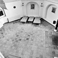
 INTERIEUR, OVERZICHT - Buurmalsen - 20306998 - RCE.jpg 1,195 × 1,200; 392 KB
-
 INTERIEUR, OVERZICHT - Buurmalsen - 20306999 - RCE.jpg 1,192 × 1,200; 513 KB
-
 INTERIEUR, OVERZICHT - Buurmalsen - 20307000 - RCE.jpg 1,193 × 1,200; 518 KB
-
 INTERIEUR, OVERZICHT - Buurmalsen - 20307001 - RCE.jpg 1,195 × 1,200; 491 KB
-

-

-

-

-
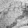
 Interieur, tufsteen in muur - Buurmalsen - 20360078 - RCE.jpg 785 × 1,200; 188 KB
-
 Interieur, tufsteen in muur - Buurmalsen - 20360079 - RCE.jpg 789 × 1,200; 173 KB
-
 Interieur, tufsteen in muur - Buurmalsen - 20360080 - RCE.jpg 783 × 1,200; 202 KB
-
 Interieur, tufsteen in muur - Buurmalsen - 20360081 - RCE.jpg 783 × 1,200; 181 KB
-
 Interieur, tufsteen in muur - Buurmalsen - 20360082 - RCE.jpg 1,200 × 784; 208 KB
-
 Interieur, tufsteen in muur - Buurmalsen - 20360089 - RCE.jpg 1,200 × 784; 204 KB
-
 Interieur, voormalige altaarstenen in de koorsluiting - Buurmalsen - 20271568 - RCE.jpg 1,200 × 1,200; 182 KB
-
 Nederlands Hervormde Suitbertus Kerk te Buurmalsen.jpg 4,608 × 3,456; 5.11 MB
-
 Noordgevel - Buurmalsen - 20046152 - RCE.jpg 1,188 × 1,200; 418 KB
-
 Noordgevel - Buurmalsen - 20046153 - RCE.jpg 1,193 × 1,200; 408 KB
-
 Oostgevel - Buurmalsen - 20046150 - RCE.jpg 1,188 × 1,200; 461 KB
-
 Overzicht - Buurmalsen - 20046146 - RCE.jpg 1,195 × 1,200; 491 KB
-
 Overzicht vanuit het zuidoosten - Buurmalsen - 20046137 - RCE.jpg 891 × 1,200; 274 KB
-
 Overzicht vanuit het zuidwesten - Buurmalsen - 20046139 - RCE.jpg 896 × 1,200; 172 KB
-
 Sarcophaag deksel - Buurmalsen - 20046145 - RCE.jpg 958 × 1,200; 259 KB
-
-
 Toren naar het noordoosten - Buurmalsen - 20046142 - RCE.jpg 953 × 1,200; 349 KB
-
 Wiel in Buurmalsen.jpg 4,529 × 3,380; 6.14 MB
-
 Zuid-gedeelte koor - Buurmalsen - 20046151 - RCE.jpg 1,200 × 1,200; 420 KB
-
 Zuidgevel - Buurmalsen - 20046147 - RCE.jpg 1,190 × 1,200; 488 KB
-
 Zuidgevel - Buurmalsen - 20046148 - RCE.jpg 1,186 × 1,200; 524 KB
-
 Zuidgevel - Buurmalsen - 20046149 - RCE.jpg 1,183 × 1,200; 416 KB


_-_Buurmalsen_-_20260399_-_RCE.jpg)


