Category:Neerstraat 62, Roermond
| Object location | | View all coordinates using: OpenStreetMap |
|---|
building in Roermond, Netherlands  | |||||
| Upload media | |||||
| Instance of |
| ||||
|---|---|---|---|---|---|
| Location | Roermond, Limburg, Netherlands | ||||
| Street address |
| ||||
| Located on street | |||||
| Heritage designation |
| ||||
 | |||||
|
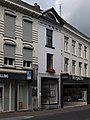
This is a category about rijksmonument number 32597
|
| Address |
|
Media in category "Neerstraat 62, Roermond"
The following 3 files are in this category, out of 3 total.
-
 Roer Neerstraat 62A.jpg 2,736 × 3,648; 4.77 MB
-
 Roermond Neerstraat 62.jpg 2,736 × 3,648; 4.68 MB
-
 Voorgevels - Roermond - 20189787 - RCE.jpg 805 × 1,200; 154 KB

