Category:Nevada State Route 164
 | number: | (one hundred sixty-four) |
|---|---|---|
| State highways in Nevada: | 146 · 147 · 156 · 157 · 158 · 159 · 160 · 161 · 163 · 164 · 165 · 168 · 169 · 170 · 171 · 172 · 173 |
state highway in Clark County, Nevada, United States  | |||||
| Upload media | |||||
| Instance of | |||||
|---|---|---|---|---|---|
| Location | Clark County, Nevada | ||||
| Transport network | |||||
| Owned by | |||||
| Maintained by | |||||
| Inception |
| ||||
| Length |
| ||||
 | |||||
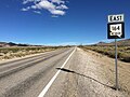
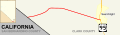
English: Media related to Nevada State Route 164 (also known as Nipton Road, and formerly Nevada State Route 68, before 1976)), a 18.584-mile (29.908 km) state highway (primary route) in southern Clark County, Nevada, United States, that continues Nipton Road from California to U.S. Route 95 at the settlement of Searchlight.
Subcategories
This category has only the following subcategory.
Media in category "Nevada State Route 164"
The following 7 files are in this category, out of 7 total.
-
-
 Nevada 164 map.svg 731 × 207; 237 KB
-
 Nevada 164.svg 600 × 600; 11 KB
-
 Nevada 68.svg 600 × 600; 13 KB
-
 Nevada Route 164 and McCullough Range.jpg 2,400 × 1,600; 657 KB
-
 Nevada Route 164 near Crescent district.jpg 2,400 × 1,800; 1,010 KB
-
 Wee Thump Joshua Tree Wilderness 1.jpg 1,800 × 1,200; 429 KB
_in_Clark_County,_Nevada.jpg)


