Category:Niederried bei Kallnach
village in the municipality of Kallnach in the canton of Bern, Switzerland _213.JPG)  | |||||
| Upload media | |||||
| Instance of | |||||
|---|---|---|---|---|---|
| Part of |
| ||||
| Location |
| ||||
| Official language | |||||
| Area |
| ||||
| Elevation above sea level |
| ||||
| Replaced by |
| ||||
| official website | |||||
 | |||||
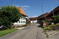
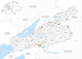
Deutsch: Niederried bei Kallnach ist ein Dorf in der Gemeinde Kallnach und war bis zum 31. Dezember 2012 eine Gemeinde im Kanton Bern in der Schweiz.
English: Niederried bei Kallnach is a municipality of the canton of Bern, Switzerland.
Subcategories
This category has the following 2 subcategories, out of 2 total.
Media in category "Niederried bei Kallnach"
The following 21 files are in this category, out of 21 total.
-
 2012-07-18-Regiono Arbergo (Foto Dietrich Michael Weidmann) 212.JPG 3,872 × 2,592; 4.49 MB
-
 2012-07-18-Regiono Arbergo (Foto Dietrich Michael Weidmann) 213.JPG 3,872 × 2,592; 4.08 MB
-
 2012-07-18-Regiono Arbergo (Foto Dietrich Michael Weidmann) 214.JPG 3,872 × 2,592; 4.22 MB
-
 2012-07-18-Regiono Arbergo (Foto Dietrich Michael Weidmann) 215.JPG 3,872 × 2,592; 3.72 MB
-
 2012-07-18-Regiono Arbergo (Foto Dietrich Michael Weidmann) 217.JPG 3,872 × 2,592; 4.36 MB
-
 2012-07-18-Regiono Arbergo (Foto Dietrich Michael Weidmann) 218.JPG 3,872 × 2,592; 3.18 MB
-
 2012-07-18-Regiono Arbergo (Foto Dietrich Michael Weidmann) 219.JPG 3,872 × 2,592; 4.37 MB
-
 2012-07-18-Regiono Arbergo (Foto Dietrich Michael Weidmann) 221.JPG 3,872 × 2,592; 3.88 MB
-
 2012-07-18-Regiono Arbergo (Foto Dietrich Michael Weidmann) 222.JPG 3,872 × 2,592; 4.27 MB
-
 2012-07-18-Regiono Arbergo (Foto Dietrich Michael Weidmann) 223.JPG 3,872 × 2,592; 3.79 MB
-
 2012-07-18-Regiono Arbergo (Foto Dietrich Michael Weidmann) 224.JPG 3,872 × 2,592; 4.21 MB
-

-
 ETH-BIB-Niederried Stausee, aufwärts von Pkt. 468 (Rübach Mündung)-Dia 247-15552 b.jpg 3,595 × 2,616; 4.76 MB
-
 ETH-BIB-Niederried Stausee, aufwärts von Pkt. 468 (Rübach Mündung)-Dia 247-15552.tif 3,595 × 2,616; 27.02 MB
-
 ETH-BIB-Niederried-Stausee, aufwärts von der Rampe, Nordost Hasenholz-Dia 247-15553.tif 3,620 × 2,680; 27.88 MB
-
 Karte Gemeinde Niederried bei Kallnach 2007.png 1,476 × 1,058; 394 KB
-
 Karte Gemeinde Niederried bei Kallnach 2010.png 2,362 × 1,709; 1.02 MB
-
 Karte Gemeinde Niederried bei Kallnach 2011.png 1,771 × 1,281; 727 KB
-
 Karte Gemeinde Niederried bei Kallnach.png 1,181 × 848; 224 KB
-
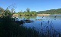 Naturschutzgebiet Niederried-Stausee.jpg 2,592 × 1,595; 1 MB
-
 Niederried bei Kallnach-coat of arms.svg 603 × 763; 11 KB
_212.JPG)
_214.JPG)
_215.JPG)
_217.JPG)
_218.JPG)
_219.JPG)
_221.JPG)
_222.JPG)
_223.JPG)
_224.JPG)
-Dia_247-15552_b.jpg)


