Category:Nisqually Glacier Bridge (1960)
bridge in the United States  | |||||
| Upload media | |||||
| Instance of | |||||
|---|---|---|---|---|---|
| Located in protected area | |||||
| Location |
| ||||
| Crosses | |||||
 | |||||
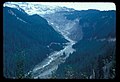
English: Media related to a bridge over the Nisqually River constructed in Mount Rainier National Park on the Nisqually River between 1958 and 1960. It replaced an earlier bridge destroyed in the 1955 Kautz Creek jökalhaup (glacial outburst flood), which itself replaced at least one prior bridge. The Nisqually forms the border between Pierce and Lewis Counties, Washington state at this location.
Subcategories
This category has only the following subcategory.
Media in category "Nisqually Glacier Bridge (1960)"
The following 8 files are in this category, out of 8 total.
-
 Nisqually Glacier and River - Flickr - brewbooks.jpg 3,216 × 4,288; 3.29 MB
-
 Nisqually River 0533s.JPG 4,164 × 5,315; 6.37 MB
-

-
-
 Road to Longmire 02.jpg 4,288 × 2,848; 6.23 MB
-
 Road to Longmire 03.jpg 4,288 × 2,848; 7.03 MB
-
 Road to Longmire 04.jpg 4,288 × 2,848; 6.5 MB
-
 Road to Longmire 05.jpg 4,288 × 2,848; 6.41 MB

.jpg)
.jpg)


