Category:Normanton on Trent
English: Normanton on Trent is a village in Nottinghamshire, England. It is nine miles south-east of Retford. According to the 2001 census it had a population of 299.
village in United Kingdom | |||||
| Upload media | |||||
| Instance of | |||||
|---|---|---|---|---|---|
| Location | Bassetlaw, Nottinghamshire, East Midlands, England | ||||
| Said to be the same as | Normanton on Trent (Wikimedia duplicated page, civil parish) | ||||
 | |||||
Subcategories
This category has the following 2 subcategories, out of 2 total.
M
N
Media in category "Normanton on Trent"
The following 123 files are in this category, out of 123 total.
-
 A plethora of pylons - geograph.org.uk - 5554190.jpg 1,280 × 960; 426 KB
-
 Approaching Normanton Sands - geograph.org.uk - 3160677.jpg 640 × 427; 155 KB
-
 Brotts Road meets Grassthorpe Road - geograph.org.uk - 4590884.jpg 3,072 × 1,728; 3.05 MB
-
 Bus to Newark - geograph.org.uk - 4104514.jpg 1,280 × 928; 317 KB
-
 Cattle next to the River Trent - geograph.org.uk - 4943533.jpg 800 × 552; 89 KB
-
 Cattle on the banks of the River Trent - geograph.org.uk - 4943489.jpg 800 × 533; 113 KB
-
 Cattle on the River Trent floodbank - geograph.org.uk - 4943507.jpg 800 × 502; 96 KB
-
 Cemetery at Normanton on Trent - geograph.org.uk - 4575404.jpg 800 × 600; 116 KB
-
 Church Farm, Normanton on Trent - geograph.org.uk - 3057003.jpg 1,024 × 768; 177 KB
-
 Clapper gates - geograph.org.uk - 4574261.jpg 800 × 600; 122 KB
-
 Clapper gates along the River Trent - geograph.org.uk - 4943601.jpg 800 × 553; 146 KB
-
 Cottage on South Street - geograph.org.uk - 2691800.jpg 640 × 480; 79 KB
-
 Daisies on the River Trent floodbank - geograph.org.uk - 4943591.jpg 800 × 600; 118 KB
-
 Danger, sunken island, keep left - geograph.org.uk - 4591479.jpg 3,072 × 1,728; 3.26 MB
-
 Danger, Sunken island, keep right - geograph.org.uk - 4591487.jpg 3,072 × 1,728; 3.6 MB
-
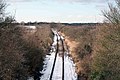
 Disused railway line - geograph.org.uk - 654608.jpg 640 × 356; 73 KB
-
 Drainage sluice - geograph.org.uk - 3160680.jpg 640 × 429; 221 KB
-
 Eastgate, Normanton on Trent - geograph.org.uk - 2691795.jpg 640 × 480; 89 KB
-
 Eastgate, Normanton-on-Trent - geograph.org.uk - 4104550.jpg 1,280 × 933; 252 KB
-
 Elizabeth Hall Cottages - geograph.org.uk - 4575458.jpg 800 × 600; 120 KB
-
 Farmland near Holly Farm - geograph.org.uk - 3512946.jpg 640 × 480; 75 KB
-
 Farmland off Skegby Road - geograph.org.uk - 2691764.jpg 640 × 480; 29 KB
-
 Farmland, Normanton on Trent - geograph.org.uk - 2691772.jpg 640 × 480; 90 KB
-
 Field at Normanton on Trent - geograph.org.uk - 3056986.jpg 1,024 × 768; 269 KB
-
 Field with large trees - geograph.org.uk - 4575461.jpg 800 × 600; 151 KB
-
 Fields by the lane to Normanton on Trent - geograph.org.uk - 2071641.jpg 900 × 675; 361 KB
-
 Fields near Normaton on Trent - geograph.org.uk - 2071648.jpg 900 × 675; 335 KB
-

-
 Flotsam at Normanton Sands - geograph.org.uk - 3160684.jpg 640 × 477; 257 KB
-
 Footbridge 29b along the River Trent - geograph.org.uk - 4943608.jpg 800 × 620; 148 KB
-
 Footbridge 29c along the River Trent - geograph.org.uk - 4943906.jpg 800 × 593; 182 KB
-

-
 Footpath to Grassthorpe Beck - geograph.org.uk - 3809906.jpg 800 × 533; 118 KB
-
 Footpath to Low Marnham - geograph.org.uk - 3809894.jpg 800 × 533; 129 KB
-
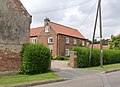
 Former gatehouse cottage, Normanton on Trent - geograph.org.uk - 4590856.jpg 3,072 × 1,728; 3.28 MB
-

-
 Grassthorpe drainage channel - geograph.org.uk - 2907601.jpg 3,648 × 2,736; 2.27 MB
-
 Grassthorpe Road - geograph.org.uk - 4590887.jpg 3,072 × 1,728; 3.53 MB
-
 Hanginghill Lane - geograph.org.uk - 2691760.jpg 640 × 480; 84 KB
-
 Holly Farm - geograph.org.uk - 3512956.jpg 640 × 480; 72 KB
-
 Holme Lane - geograph.org.uk - 3809900.jpg 800 × 533; 115 KB
-
 Hopyard Lane - geograph.org.uk - 389529.jpg 640 × 427; 94 KB
-
 Ineffective gate - geograph.org.uk - 679832.jpg 640 × 480; 138 KB
-
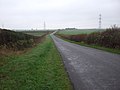
 Lane into Normanton on Trent - geograph.org.uk - 2071687.jpg 900 × 637; 403 KB
-
 Lane to Grassthorpe - geograph.org.uk - 4921536.jpg 3,546 × 2,298; 4.16 MB
-
 Lane to Low Marnham - geograph.org.uk - 4921520.jpg 4,424 × 2,583; 7.22 MB
-
 Minor road towards Stone Road End - geograph.org.uk - 2691775.jpg 640 × 480; 59 KB
-
 Normanton Hall Lodge - geograph.org.uk - 4104517.jpg 1,280 × 843; 191 KB
-
 Normanton on Trent postbox, ref NG23 130 - geograph.org.uk - 4104552.jpg 960 × 1,280; 468 KB
-
 Normanton-on-Trent village hall - geograph.org.uk - 4104554.jpg 1,280 × 960; 284 KB
-

-
-
 Old gravel loading stages opposite Normanton Holme - geograph.org.uk - 4591477.jpg 3,072 × 1,728; 3.51 MB
-
 Ordnance Survey Cut Mark - geograph.org.uk - 4982745.jpg 640 × 477; 119 KB
-
 Overgrown railway trackbed - geograph.org.uk - 1589739.jpg 640 × 449; 89 KB
-
 Path and stile near Low Marnham - geograph.org.uk - 4941961.jpg 800 × 626; 160 KB
-
 Path to Skegby - geograph.org.uk - 3056976.jpg 1,024 × 768; 240 KB
-
 Path towards Weston, Normanton on Trent - geograph.org.uk - 4590842.jpg 2,339 × 1,728; 1.59 MB
-
 Poppies beside Brotts Road - geograph.org.uk - 4575402.jpg 800 × 600; 204 KB
-
 Power station Towers - geograph.org.uk - 1587796.jpg 640 × 462; 79 KB
-
 Pylon in a rape field, near Normanton on Trent - geograph.org.uk - 4920942.jpg 3,696 × 2,448; 2.29 MB
-
 Pylons and Power Station - geograph.org.uk - 322254.jpg 480 × 640; 75 KB
-
 Railway track bed - geograph.org.uk - 1588807.jpg 640 × 424; 98 KB
-
 Railway yard no more - geograph.org.uk - 1588447.jpg 640 × 404; 48 KB
-
 River Trent in flood at Girton - geograph.org.uk - 338318.jpg 640 × 427; 43 KB
-

-
 Road towards Grassthorpe - geograph.org.uk - 3512950.jpg 640 × 480; 48 KB
-
 Rusty Rails - geograph.org.uk - 166177.jpg 640 × 480; 92 KB
-
 Skegby Road pylons - geograph.org.uk - 1170807.jpg 640 × 469; 48 KB
-
 Sluice feeding the river - geograph.org.uk - 3160672.jpg 640 × 421; 212 KB
-
 Snow on the line - geograph.org.uk - 1160595.jpg 640 × 427; 91 KB
-
 South Street - geograph.org.uk - 1988436.jpg 640 × 426; 89 KB
-
 South Street, Normanton on Trent - geograph.org.uk - 2071697.jpg 900 × 667; 367 KB
-
 Speed information sign - geograph.org.uk - 4575459.jpg 800 × 600; 119 KB
-
 Square and Compass - geograph.org.uk - 3579688.jpg 640 × 480; 100 KB
-

-
 Stile and footpath entrance off Tuxford Road - geograph.org.uk - 4920931.jpg 2,448 × 3,696; 2.31 MB
-
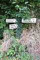
 The beginning of the footpath to Weston on Trent - geograph.org.uk - 3059290.jpg 768 × 1,024; 322 KB
-
 The beginning of the path to Low Marnham - geograph.org.uk - 3059279.jpg 1,024 × 768; 294 KB
-
 The cemetery, Normanton on Trent - geograph.org.uk - 3059288.jpg 1,024 × 768; 254 KB
-
 The Crown Inn - geograph.org.uk - 4575456.jpg 800 × 600; 99 KB
-
 The Crown, Normanton on Trent - geograph.org.uk - 2691805.jpg 640 × 480; 72 KB
-
 The Crown, Normanton-on-Trent - geograph.org.uk - 4104510.jpg 1,280 × 967; 284 KB
-
 The end of Brotts Lane - geograph.org.uk - 4104509.jpg 1,280 × 882; 311 KB
-
 The Manor, Normanton-on-Trent - geograph.org.uk - 4104513.jpg 1,280 × 929; 363 KB
-
 The Old Smithy, Normanton on Trent - geograph.org.uk - 3059276.jpg 1,024 × 768; 201 KB
-
 The River Trent near Normanton Holme - geograph.org.uk - 4943901.jpg 800 × 542; 102 KB
-
 The School House - geograph.org.uk - 1988431.jpg 640 × 426; 95 KB
-
 The School House, Normanton on Trent - geograph.org.uk - 3056995.jpg 1,024 × 768; 179 KB
-
 The School House, Normanton-on-Trent - geograph.org.uk - 4104515.jpg 1,280 × 964; 357 KB
-
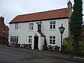
 The Square and Compass - geograph.org.uk - 2071656.jpg 900 × 505; 308 KB
-
 The Square ^ Compass - geograph.org.uk - 4575464.jpg 800 × 600; 132 KB
-
 The Square ^ Compass - geograph.org.uk - 4575466.jpg 800 × 600; 83 KB
-
 The Square ^ Compass, Normanton on Trent - geograph.org.uk - 4590837.jpg 3,072 × 1,728; 1.54 MB
-
 Threeways - geograph.org.uk - 1988439.jpg 640 × 426; 93 KB
-
 Trentman Lodge near Normanton on Trent - geograph.org.uk - 4941956.jpg 800 × 587; 115 KB
-
 Tuxford Road heading east - geograph.org.uk - 2691781.jpg 640 × 480; 69 KB
-
 Up the Trent - geograph.org.uk - 3160670.jpg 640 × 427; 152 KB
-
 Village scene, Normanton on Trent - geograph.org.uk - 2071672.jpg 900 × 675; 346 KB
-
 Vine House, Normanton-on-Trent - geograph.org.uk - 4104512.jpg 1,280 × 960; 335 KB
-
 Vine House, South Street, Normanton on Trent - geograph.org.uk - 3059282.jpg 1,024 × 768; 213 KB
-
 Walton Farm Cottage - geograph.org.uk - 4575400.jpg 800 × 600; 125 KB
-
 Watch your speed in Normanton on Trent - geograph.org.uk - 4590853.jpg 3,072 × 1,728; 3.63 MB
-
 Weston Lane - geograph.org.uk - 2478568.jpg 640 × 427; 94 KB
-
 Works discharge point - geograph.org.uk - 3160688.jpg 640 × 452; 155 KB
-
 Bottom of the Square - geograph.org.uk - 322248.jpg 640 × 480; 95 KB
-
 Brotts Road - geograph.org.uk - 389541.jpg 640 × 427; 49 KB
-
 Disused rail bridge - geograph.org.uk - 654603.jpg 640 × 480; 128 KB
-
 Footpath to Low Marnham - geograph.org.uk - 388078.jpg 640 × 427; 68 KB
-
 Grassthorpe Beck - geograph.org.uk - 388084.jpg 640 × 427; 98 KB
-
 Grassthorpe Beck - geograph.org.uk - 388156.jpg 640 × 427; 128 KB
-
 High Water on the Trent - geograph.org.uk - 340151.jpg 640 × 427; 34 KB
-
 Holme Lane - geograph.org.uk - 389521.jpg 640 × 427; 74 KB
-
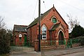 Normanton Methodist Church - geograph.org.uk - 92400.jpg 640 × 427; 73 KB
-

-
 Pinfold commemorative stone - geograph.org.uk - 388183.jpg 640 × 427; 113 KB
-
 Polly Taylors Road - geograph.org.uk - 679842.jpg 640 × 421; 98 KB
-

-
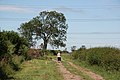
 Towards Holly Farm - geograph.org.uk - 389549.jpg 640 × 427; 43 KB
-
 Trantman Lodge - geograph.org.uk - 389554.jpg 640 × 427; 73 KB
-
 Two Paths From One - geograph.org.uk - 322240.jpg 640 × 480; 143 KB
-
 Weeping Willows - geograph.org.uk - 388164.jpg 640 × 427; 109 KB
-
 West of Normanton - geograph.org.uk - 322243.jpg 640 × 480; 133 KB


