Category:Northfield Falls Covered Bridge
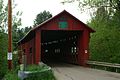
Northfield Falls Covered Bridge, Dog River, Cox Brook Road, Northfield Falls, Northfield, Vermont.
| Object location | | View all coordinates using: OpenStreetMap |
|---|
Media in category "Northfield Falls Covered Bridge"
The following 2 files are in this category, out of 2 total.
-
 Covered Bridge Northfield Falls 1 (6236673419).jpg 3,109 × 3,171; 4.71 MB
-
 NorthfieldFallsBridge.JPG 3,008 × 2,000; 3.12 MB
.jpg)
