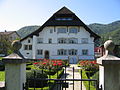
Category:Obere Mühle (Bahnhofstrasse 24, Egerkingen)
| Object location | | View all coordinates using: OpenStreetMap |
|---|
building in Egerkingen in the canton of Solothurn Switzerland  | |||||
| Upload media | |||||
| Instance of |
| ||||
|---|---|---|---|---|---|
| Part of | |||||
| Location | Egerkingen, Gäu District, Thal-Gäu, Solothurn, Switzerland | ||||
| Street address |
| ||||
| Heritage designation | |||||
| Inception |
| ||||
 | |||||
Media in category "Obere Mühle (Bahnhofstrasse 24, Egerkingen)"
The following 2 files are in this category, out of 2 total.
-
 Alte Mühle Egerkingen.JPG 2,592 × 1,944; 2.31 MB
-
 The Old Mill (Alte Mühle), Egerkingen.jpg 4,000 × 3,000; 3.38 MB
,_Egerkingen.jpg)