Category:Oberer Brandl B 13 (Neuburg an der Donau)
| Object location | | View all coordinates using: OpenStreetMap |
|---|
building in Neuburg an der Donau, Upper Bavaria, Germany  | |||||
| Upload media | |||||
| Instance of | |||||
|---|---|---|---|---|---|
| Location | Neuburg an der Donau, Neuburg-Schrobenhausen, Upper Bavaria, Bavaria, Germany | ||||
| Street address |
| ||||
| Heritage designation | |||||
 | |||||
This is the category of the Bavarian Baudenkmal (cultural heritage monument) with the ID D-1-85-149-168 (Wikidata)
|
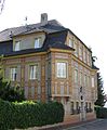
Deutsch: Ehemaliges Adelspalais, sogenanntes Baron-Giessen-Haus, Zweigeschossiger freistehender Bau mit Schopf-Mansarddach und aufgemalter Gliederung, Giebelfeld durch Pilaster unterteilt, nach Süden und Norden im Obergeschoss Kastenerker, reich gestaltetes Portal, um 1720.
Oberer Brandl B 13,Neuburg an der Donau, Bayern, Deutschland
Oberer Brandl B 13,Neuburg an der Donau, Bayern, Deutschland
Media in category "Oberer Brandl B 13 (Neuburg an der Donau)"
The following 3 files are in this category, out of 3 total.
-
 Oberer Brandl B13 Neuburg-1.jpg 1,944 × 2,493; 855 KB
-
 Oberer Brandl B13 Neuburg-2.jpg 1,944 × 2,592; 1.01 MB
-
 Oberer Brandl B13 Neuburg-3.jpg 1,911 × 2,310; 710 KB

