Category:Oberes Türmlihaus, Furt
| Object location | | View all coordinates using: OpenStreetMap |
|---|
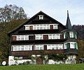
Deutsch: Das obere Türmlihaus ist ein Wohnhaus (heute Bauernhaus) im Weiler Furt (früher auch; Furth) auf dem Gebiet der politischen Gemeinde Neckertal im Kanton St. Gallen in der Schweiz.
 | |||||
| Upload media | |||||
| Instance of | |||||
|---|---|---|---|---|---|
| Location |
| ||||
| Street address |
| ||||
| Heritage designation | |||||
 | |||||
Media in category "Oberes Türmlihaus, Furt"
The following 11 files are in this category, out of 11 total.
-
 Neckertal Furt Türmlihäuser.JPG 4,246 × 2,820; 4.85 MB
-
 Neckertal Oberes Türmlihaus s.JPG 3,531 × 2,929; 3.68 MB
-
 Neckertal Oberes Türmlihaus so.JPG 3,883 × 2,805; 3.78 MB
-
 Neckertal Oberes Türmlihaus sw.JPG 3,684 × 2,696; 3.62 MB
-
 Toggenburg Oberes Türmilhaus background hill.jpg 4,256 × 2,832; 8.97 MB
-
 Toggenburg Oberes Türmlihaus close view.jpg 4,256 × 2,832; 8.62 MB
-
 Toggenburg Oberes Türmlihaus contextual view.jpg 2,832 × 4,256; 11.76 MB
-
 Toggenburg Oberes Türmlihaus general overview.jpg 4,256 × 2,832; 10.72 MB
-
 Toggenburg Oberes Türmlihaus tower detail.jpg 2,832 × 4,256; 8.16 MB
-
 Toggenburg Oberes und Unteres Türmilhaus.jpg 2,495 × 3,763; 8.68 MB
-
 Toggenburg Unteres und Oberes Türmlihaus.jpg 2,683 × 4,115; 9.91 MB


