Category:October 2006 in the Scottish Borders
Council areas (municipalities) of Scotland: Aberdeenshire · Argyll and Bute · Falkirk · Highland · Scottish Borders ·
Deutsch: Bilder, die im Oktober 2006 in the Scottish Borders aufgenommen worden sind. Bitte beachten Sie, dass dies weder das Datum des Uploads noch das Datum des Scannens eines Fotos ist.
English: Images/pictures taken in the Scottish Borders during October 2006. Note this is not the date of the upload, nor the date a photo was scanned.
Español: Fotografías o imágenes tomadas en the Scottish Borders durante octubre 2006. No es la fecha de subida ni escaneo, sino la fecha en que las fotografías o imágenes se crearon.
Esperanto: Bildoj faritaj en the Scottish Borders en oktobro 2006. Tio ne estas la dato, kiam la bildoj estis alŝutitaj aŭ skanitaj.
Français : Photographies ou images prises en the Scottish Borders durant octobre 2006. Ce n'est pas la date du téléchargement ou du scan.
Galego: Fotografías ou imaxes tomadas en the Scottish Borders durante outubro 2006. Non é a data de subida nin escaneamento, senón a data na que se crearon as fotografías ou imaxes.
Italiano: Fotografie o immagini scattate a the Scottish Borders nel ottobre 2006. Nota bene: la data non si riferisce né a quella di upload né a quella in cui la foto è stata digitalizzata.
Norsk bokmål: Bilder tatt i the Scottish Borders i løpet av oktober 2006. Merk at dette ikke er datoen for opplasting, eller når et bilde har blitt skannet.
Norsk nynorsk: Bilete teke i the Scottish Borders i løpet av oktober 2006. Merk at dette ikkje er datoen for opplasting, eller når eit bilete har vorte skanna.
Русский: Изображения, сделанные в the Scottish Borders в течение октябрь 2006 (не дата загрузки изображения).
Українська: Зображення, зроблені в the Scottish Borders протягом жовтень 2006. Зауважте, що це не дата завантаження чи дата сканування фотографії.
| October 2005 | ← | October 2006 | → | October 2007 | |||||||
| Jan | Feb | Mar | Apr | May | Jun | Jul | Aug | Sep | Oct | Nov | Dec |
| 5 | 7 | 0 | 0 | 11 | 25 | 27 | 0 | 31 | 25 | 0 | 39 |
|---|---|---|---|---|---|---|---|---|---|---|---|
Media in category "October 2006 in the Scottish Borders"
The following 25 files are in this category, out of 25 total.
-
 A concrete shelter near Penchrise Pen - geograph.org.uk - 258027.jpg 640 × 480; 56 KB
-
 A country road - geograph.org.uk - 255073.jpg 640 × 456; 53 KB
-

-
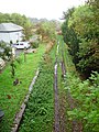
 Disused railway - geograph.org.uk - 270059.jpg 640 × 480; 71 KB
-
 Disused railway line - geograph.org.uk - 259931.jpg 640 × 459; 71 KB
-
 Disused railway line near Sprouston - geograph.org.uk - 270013.jpg 640 × 480; 63 KB
-
 Disused Railway near Innerleithen - geograph.org.uk - 260409.jpg 640 × 480; 80 KB
-
 Disused railway near Kerchesters - geograph.org.uk - 270029.jpg 640 × 480; 104 KB
-
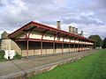
 Edrom Station - geograph.org.uk - 275796.jpg 480 × 640; 119 KB
-

-

-

-
 Newlands - geograph.org.uk - 347481.jpg 640 × 480; 90 KB
-
 Old Railway beside River Tweed - geograph.org.uk - 280025.jpg 640 × 480; 163 KB
-
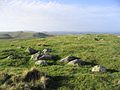
 Rough grazing in the Cheviot Hills - geograph.org.uk - 270182.jpg 640 × 496; 57 KB
-
 Simprim - geograph.org.uk - 272484.jpg 640 × 480; 66 KB
-
 Simprim Mains - geograph.org.uk - 276481.jpg 640 × 480; 89 KB
-
 The former Melrose Railway Station - geograph.org.uk - 255694.jpg 640 × 480; 48 KB
-
 The former Melrose Railway Station - geograph.org.uk - 255709.jpg 640 × 480; 66 KB
-
 The summit area of Whitestone Hill - geograph.org.uk - 269519.jpg 640 × 480; 62 KB
-
 The village of Chesters - geograph.org.uk - 258021.jpg 640 × 435; 62 KB
-
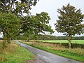 Tree lined road - geograph.org.uk - 276480.jpg 640 × 480; 126 KB
-
 Whitestone Hill - geograph.org.uk - 269521.jpg 640 × 480; 60 KB
-
 Signpost, Ada Hill. - geograph.org.uk - 269279.jpg 640 × 480; 316 KB
-
 Signpost, Cloich Forest. - geograph.org.uk - 269049.jpg 480 × 640; 284 KB


