Category:Old linguistic maps of Europe
Subcategories
This category has the following 2 subcategories, out of 2 total.
Media in category "Old linguistic maps of Europe"
The following 16 files are in this category, out of 16 total.
-
 Folkesprogene i Hertugdømmet Slesvig (Higher Resolution Version).png 3,456 × 5,184; 25.97 MB
-
 Folkesprogene i Hertugdømmet Slesvig (Map Only Version).png 2,826 × 3,888; 20.3 MB
-
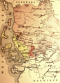
 Folkesprogene i Hertugdømmet Slesvig.png 865 × 1,341; 1.91 MB
-
 KaartOverFolkesprogSlesvigEllerSønderjylland (Map Only Version).png 597 × 663; 792 KB
-
 Une vue des langues d'Europe en 1859.png 688 × 648; 585 KB
-
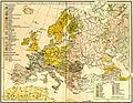 Europe ethnic map 1897 (hungarian).jpg 2,316 × 1,800; 907 KB
-
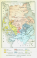
 Folk- och språk-karta öfver Europa, Nordisk familjebok.jpg 2,477 × 1,622; 898 KB
-
 1942 German Dialects (30249105593).jpg 3,167 × 2,199; 1.38 MB
-

-
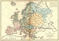 Indo-European languages. Map of Europe (1850).jpg 6,582 × 4,595; 17.98 MB
-
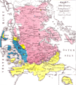
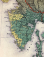 Istria (ethnic)-Czörnig.png 515 × 668; 932 KB
-
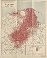
 Ludność kaszubska na Ziemi Miasteckiej w końcu XIX w.jpg 931 × 865; 512 KB
-
 Ludność kaszubska na Ziemi Słupskiej w koń. XIX w.jpg 739 × 896; 437 KB
-
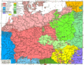 Sprachenkarte Deutschland1880.png 1,513 × 1,166; 356 KB
-
 Stefan Ramułt, Mapa etnograficzna Kaszub, 1899.jpg 1,904 × 2,334; 2.64 MB
-
 A.L. Hickmann's geographisch-statistischer universel-Taschen-Atlas. 1900 (80112070).jpg 5,264 × 4,324; 4.36 MB
.png)
.png)

.png)

.jpg)

.jpg)
.jpg)
.jpg)
-Cz%C3%B6rnig.png)


.jpg)