Category:Old maps of Bornholm
Media in category "Old maps of Bornholm"
The following 25 files are in this category, out of 25 total.
-
 -ImageRoenne 1900 - place marked where Johan Printzensköld was murdered.jpg 1,011 × 1,210; 192 KB
-
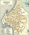 -ImageRoenne 1900.jpg 1,011 × 1,210; 914 KB
-
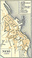 -Nexoe 1900.jpg 671 × 1,230; 618 KB
-
 -Svaneke 1900.jpg 581 × 877; 355 KB
-
 Aakirke-Bye.jpg 4,724 × 3,707; 4.71 MB
-

-
 Collier's 1921 Denmark.jpg 1,888 × 2,290; 1.47 MB
-

-

-
 Aakirkeby 1900 (cropped).jpg 657 × 514; 260 KB
-
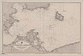 Admiralty Chart No 2150 Baltic Giedser Odde to Bornholm (Denmark), Published 1908.jpg 12,407 × 8,325; 11.01 MB
-
 Allinge 1900 (cropped).jpg 574 × 836; 418 KB
-
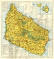
 Bornholm 1900.jpg 4,183 × 5,359; 13.43 MB
-
 Bornholm Anno 1900-a.tif 3,246 × 3,501; 20.37 MB
-
 Bornholm map from early XIX century.png 869 × 1,127; 2.06 MB
-
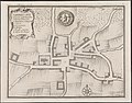
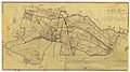
 Grund-Tegning af Rönne Kiöbstæd paa Bornholm.jpg 4,724 × 3,587; 4.23 MB
-
 Hammerhus mm.jpg 921 × 757; 577 KB
-
 Hasle Bornholm 1900 (cropped).jpg 592 × 830; 437 KB
-
 Hasle, Bornholm (Pontopidans Danske Atlas).jpg 500 × 339; 50 KB
-
 Karte des Deutschen Reichs (Vogel) - Section 03 - Rügenwalde.png 4,980 × 4,170; 7.97 MB
-
 Kort over Louiselund.jpg 2,776 × 3,172; 1.81 MB
-
 Matr 1a Orginal Anders lind matrikelkort 1838.jpg 9,000 × 5,054; 10.78 MB
-

-
 Statistisk-topographisk beskrivelse af kongeriget Danmark (1872) (14781978902).jpg 2,960 × 1,222; 445 KB
-
 Continental Atlas fur Mittel-Europa 1925 (133609772).jpg 5,822 × 4,988; 28.56 MB


.jpg)

_(14777419672).jpg)
.jpg)
.jpg)
,_Published_1908.jpg)
.jpg)


.jpg)
.jpg)
_-_Section_03_-_R%C3%BCgenwalde.png)


_(14781978902).jpg)
.jpg)