Category:Old maps of Geneva
Subcategories
This category has only the following subcategory.
M
- Maps of fortifications in Geneva (17 F)
Media in category "Old maps of Geneva"
The following 44 files are in this category, out of 44 total.
-
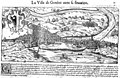
 Geneva 1552.jpg 2,881 × 1,866; 1.07 MB
-
 Cosmographie universelle 60827.jpg 3,036 × 1,963; 4.32 MB
-
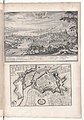
 Genf, Switzerland (1600) center.jpg 800 × 600; 154 KB
-
 Genf, Switzerland (1600) left.jpg 800 × 600; 157 KB
-
 Genf, Switzerland (1600) right.jpg 800 × 600; 137 KB
-
 Genf, Switzerland (1600).jpg 800 × 600; 108 KB
-
 Theatrum Vrbium 00187 Genf.jpg 1,207 × 937; 329 KB
-

-
 De Merian Helvetiae, Rhaetiae et Valesiae 165.png 1,250 × 1,050; 418 KB
-
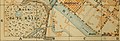
 CarteGenève.jpg 435 × 182; 141 KB
-
 Genève - btv1b53152762r (1 of 2).jpg 4,486 × 6,399; 6.48 MB
-
 Veüe du pays autour de Genève.jpg 4,594 × 2,626; 6.14 MB
-
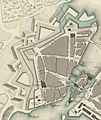
 Micheli-du-Crest-1730.jpg 550 × 381; 117 KB
-
 1773 map, Chalmandrier - plan de Genève (cropped).jpg 663 × 531; 220 KB
-
 Chalmandrier - plan de Genève.jpg 1,283 × 985; 569 KB
-
 Geneve Lac.tif 3,522 × 2,388; 17.33 MB
-
-
 Map of Geneva in 1825 cropped.jpg 1,590 × 1,158; 2.81 MB
-
 Map of Geneva in 1825.jpg 2,565 × 2,046; 2.64 MB
-
 Geneva 1841 (cropped) - quartier saint gervais.jpg 2,039 × 2,425; 1.91 MB
-
 Geneva 1841 (cropped) -Rues Basses, Molard, Rue du Rhône.jpg 1,320 × 894; 504 KB
-
 Geneva 1841-c.jpg 2,592 × 2,539; 1.72 MB
-
 Geneva 1841.jpg 6,288 × 4,787; 4.23 MB
-
 Map of Geneva in 1841.jpg 1,306 × 1,024; 1.01 MB
-
 1853-54-Porte-de-neuve-CarteBriquet.png 479 × 379; 394 KB
-

-

-

-
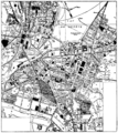
 Sécheron-carte Siegfried 1898-1915.png 883 × 683; 1.24 MB
-
 Sécheron-carte Siegfried 1898-1915.svg 883 × 683; 1.67 MB
-
 P469 - écoles et hopitaux de genève - Liv4-Ch11.png 1,440 × 1,614; 1.06 MB
-
-
 Cancel de Genève 1428-1490.jpg 3,231 × 2,876; 1.84 MB
-

-
 UNTS 1 map.png 647 × 843; 489 KB
-
 215 of 'Histoire de la Nation suisse' (11234560013).jpg 2,432 × 1,744; 1.27 MB
-

-
 A plan of Geneva and the environs - by I. Rocque - btv1b53042694x.jpg 7,920 × 6,094; 12.31 MB
-
 A Plan of Geneva with the Adjacent Parts - P. Martel delin. - btv1b5971719d.jpg 7,986 × 6,201; 8.19 MB
-

-
 A Plan of Geneva, with the adjacent parts. P. Martel delin - btv1b530293002.jpg 8,713 × 6,569; 13.56 MB
-
 CH-NB - Grafiken Orts- und Landschaftsansichten - GS-GRAF-ANSI-GE-41.tif 7,111 × 5,714, 2 pages; 116.32 MB
-
 Fortifications Micheli du Crest 1730.jpg 565 × 408; 61 KB
-
 Map of Geneva - btv1b8460214f.jpg 5,256 × 6,201; 5.17 MB


_center.jpg)
_left.jpg)
_right.jpg)
.jpg)

.jpg)


.jpg)


.jpg)


_-_quartier_saint_gervais.jpg)
_-Rues_Basses,_Molard,_Rue_du_Rh%C3%B4ne.jpg)


%27_(11245005603).jpg)
.jpg)
.jpg)


.jpg)
%27_(11244775096).jpg)


_(14597133008).jpg)