Category:Old maps of Germany 1938-1945 (Stielers Handatlas)
Media in category "Old maps of Germany 1938-1945 (Stielers Handatlas)"
This category contains only the following file.
-
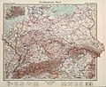 Grossdeutsches Reich.jpg 9,839 × 8,050; 10.86 MB
| “Old maps” means maps authored over 70 years ago, that is, in 1953 or earlier. |
This category contains only the following file.
