Category:Old maps of Grimsby
Subcategories
This category has only the following subcategory.
G
Media in category "Old maps of Grimsby"
The following 5 files are in this category, out of 5 total.
-

-
 Admiralty Chart No 1188 River Humber Spurn Point to Immingham Dock, Published 1949.jpg 16,271 × 11,095; 66.61 MB
-
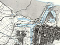 Grimsby c.1887 Ordnance Survey 1 to 10560.jpg 935 × 709; 433 KB
-
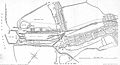
 No.3 Dock Grimsby (diagram).jpg 940 × 508; 193 KB
-
 Royal and fish dock, Grimsby c.1864.jpg 2,234 × 1,210; 593 KB
.jpg)


.jpg)
