Category:Old maps of Kochi, Kerala
Subcategories
This category has only the following subcategory.
Media in category "Old maps of Kochi, Kerala"
The following 15 files are in this category, out of 15 total.
-

-
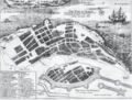
 Johannes Vingboons - De stadt Couchijn (1665).jpg 1,280 × 897; 261 KB
-
 Fort Kochi City Map 1672.png 1,170 × 888; 1.61 MB
-
 Cochin1729.jpg 1,024 × 768; 375 KB
-
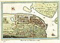 Plan de la ville de Cochin (Cochim) Paris 1761.jpg 6,536 × 4,700; 2.42 MB
-

-
 AMH-5358-NA Map of the island of Waipin.jpg 2,400 × 1,451; 365 KB
-
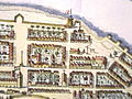
 Cochin1.jpg 388 × 311; 23 KB
-
 Cochin2.jpg 403 × 302; 34 KB
-
 Cochin4.jpg 403 × 302; 40 KB
-
 Map India and Pakistan 1-250,000 Tile NC 43-11 Cochin, Ernakulam and Vicinity (verso).jpg 5,000 × 3,824; 1.04 MB
-
 Map of Cochin.jpg 1,530 × 1,088; 249 KB
-
 Map of Portuguese Cochin.jpg 1,180 × 793; 711 KB
-
 Planta de cochim bocarro 1635.jpg 6,038 × 4,166; 6.68 MB
-
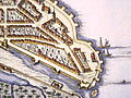
 Ville de Cochin.jpg 403 × 302; 37 KB

.jpg)


_Paris_1761.jpg)


.jpg)


